At 1:00 a.m. on July 18, the storm center was at approximately 16.4°N – 125.3°E, in the sea east of Luzon Island (Philippines). Strongest wind: level 8 (62–74km/h), gusting to level 10. Moving northwest, speed approximately 20km/h.
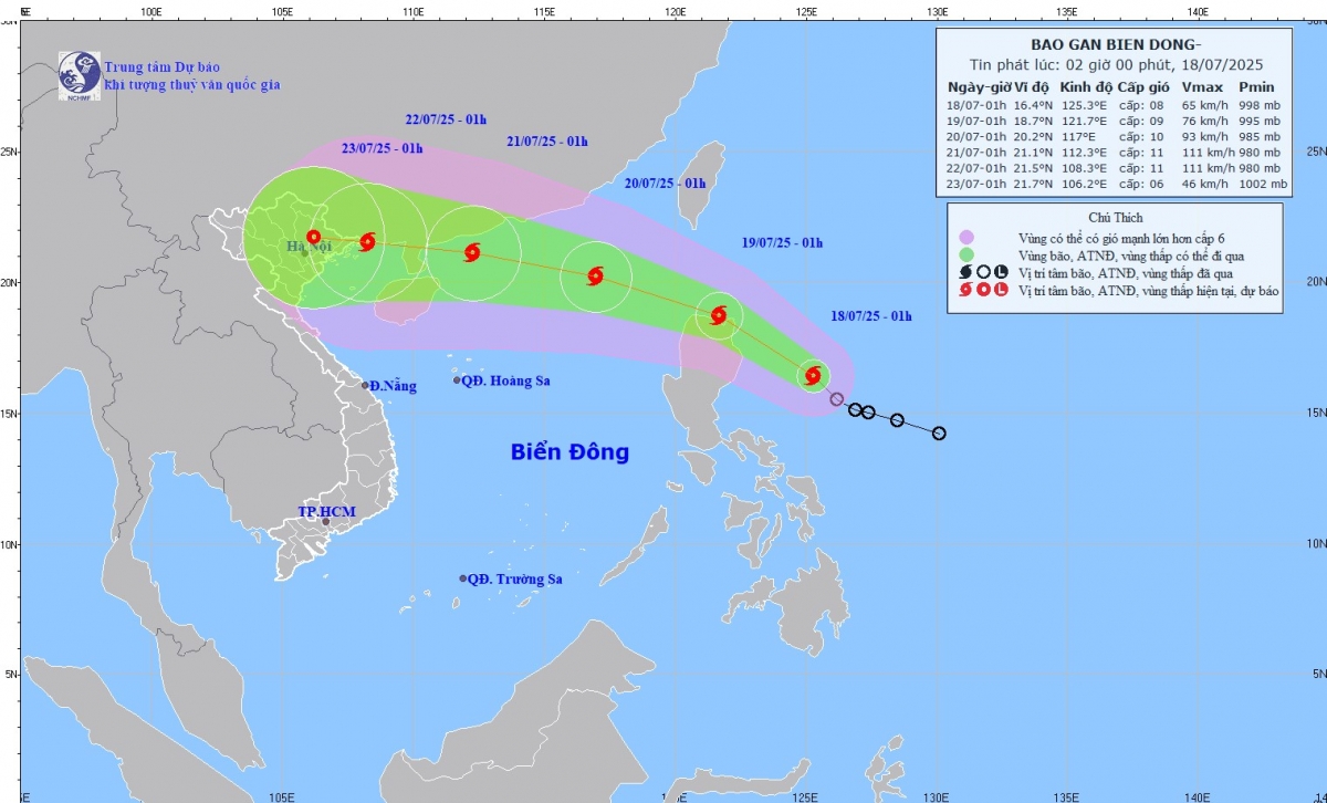
Forecast at 1am on July 19, the storm is moving northwest, at a speed of about 20km/h, with the possibility of strengthening. The center of the storm is at 18.7°N – 121.7°E, in the sea north of Luzon Island (Philippines). Intensity: level 8–9, gust level 11.
At 1:00 a.m. on July 20, the storm will move west-northwest at 20-25 km/h, likely to enter the East Sea and strengthen. The center of the storm is located at 20.2°N – 117.0°E, about 740km east-southeast of Leizhou Peninsula (China). The intensity is level 10, gusting to level 12. Dangerous area is 17.5°N – 22.5°N, 115.5°E – 120.0°E. Disaster risk level 3 – northeastern sea area of the North East Sea.
At 1:00 a.m. on July 21, the storm continued to move west-northwest, 20-25 km/h. The center of the storm is located at 21.1°N – 112.3°E, about 220 km east of Leizhou Peninsula (China). Intensity level 11, gust level 14. Dangerous area: north of latitude 18.0°N, from 110.5°E – 119.0°E. Disaster risk level: Level 3 – sea area north of the North East Sea.
Forecast from the next 72 to 120 hours, the storm will move in the West Northwest direction, speed about 20km/h.
Due to the storm, from the afternoon of July 18, the northeastern part of the East Sea will have strong winds of level 6-7, gusting to level 9. Waves will be 2.5-3.5m high, and the sea will be rough. Ships operating in the danger zone are at high risk of being affected by strong winds, large waves, whirlwinds, and severe thunderstorms.
Source: https://baolaocai.vn/bao-wipha-se-di-chuyen-nhanh-va-dat-cuong-do-cap-10-khi-vao-bien-dong-post649039.html

















![[Infographic] In 2025, 47 products will achieve national OCOP](https://vphoto.vietnam.vn/thumb/402x226/vietnam/resource/IMAGE/2025/7/16/5d672398b0744db3ab920e05db8e5b7d)


Comment (0)