

Typhoon Yinxing is likely to enter the East Sea in the next 2 days, becoming storm number 7. The heavy rain area in the Central region will shift south and end on November 8.
WATCH VIDEO :
This afternoon (November 6), Mr. Vu Anh Tuan, Deputy Head of Weather Forecast Department, National Center for Hydro-Meteorological Forecasting, updated information about storm Yinxing (at 11am) and the heavy rains occurring in the Central region.
According to Mr. Tuan, currently, a very strong storm, internationally named Yinxing, is active in the sea northeast of Luzon Island (Philippines).
At 10am, the strongest wind near the storm center was level 13 (134-149km/h), gusting to level 16. Moving northwest at a speed of about 15km/h.
“Latest update, around November 8, the storm is likely to enter the eastern area of the North East Sea, becoming storm number 7 in this year's rainy and stormy season,” Mr. Tuan informed.
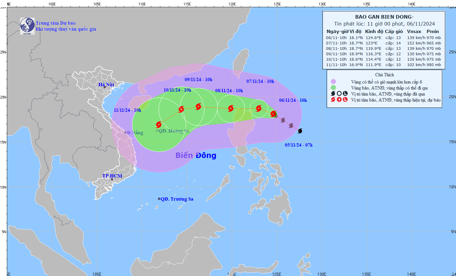
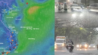
According to Mr. Tuan, when entering the eastern sea of the North East Sea, the storm will be at level 12-13. When entering the East Sea, the storm is likely to be affected by cold air, the sea surface temperature will decrease and the environment will also change. Therefore, the intensity of the storm will also change, especially when entering the northeastern area of the Hoang Sa archipelago.
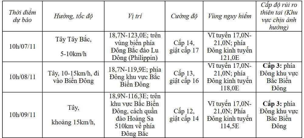
The latest assessment of the Forecast Center is that from November 8-10, the storm will move northeast to the north of Hoang Sa, then gradually shift southwest and head towards the Hoang Sa archipelago.
The trajectory and intensity of storm No. 7, if it is able to enter the East Sea, will change, so people need to update and follow the next news.
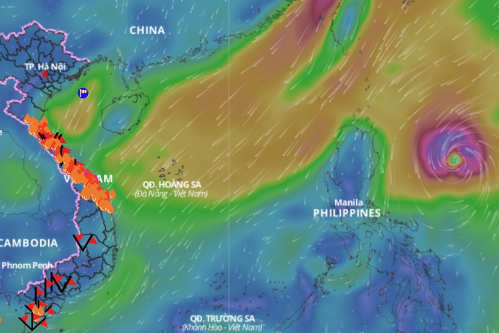
In addition, due to the influence of storm Yinxing, the sea area east of the North East Sea will have strong winds of level 6-7. From this evening and tomorrow night (November 7), it will increase to level 8-10, the area near the storm center will have levels 11-13, gusts of level 16, waves 4-6m high, the area near the center will have 6-8m; the sea will be very rough.
Ships operating in the above mentioned dangerous areas are susceptible to the effects of storms, whirlwinds, strong winds and large waves.
Heavy rains in the central region move south
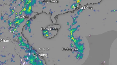
Mr. Vu Anh Tuan also said that the heavy rain in the Central provinces from last night to this morning has moved south through Hai Van Pass. The main cause of the rain is due to the disturbance of the east wind and cold air moving south.
Specifically, the area from Thua Thien Hue to Binh Dinh has heavy to very heavy rain with total rainfall of 50-100mm. Some places in Quang Nam , Quang Ngai and northern Binh Dinh have seen rain of over 200mm.
According to the assessment, this rainy area will continue to expand southward, to Khanh Hoa and last from now until November 7 with a total rainfall of 50-100mm, with some places still experiencing 200mm of rain. In particular, some places will experience 100mm of rain in 6 hours.
Heavy rain in Central Vietnam ends from November 8 According to the National Center for Hydro-Meteorological Forecasting, last night and this morning (November 6), in the area from Ha Tinh to Binh Dinh, there was moderate rain, heavy rain, and some places had very heavy rain. The rainfall from 7:00 p.m. on November 5 to 8:00 a.m. on November 6 was over 200mm in some places, such as: Bach Ma (Thua Thien Hue) 222mm, Tra Giap (Quang Nam) 254.2mm, Tra Thanh (Quang Ngai) 297.8mm, Bong Son (Binh Dinh) 270.7mm, ... It is forecasted that from the morning of November 6 to the end of November 7, the area from Quang Nam to Khanh Hoa will have moderate rain, heavy rain, locally very heavy rain with rainfall from 50-100mm, locally over 200mm, warning of the risk of local heavy rain (>100mm/6 hours); the area from Quang Tri to Da Nang will have rain, moderate rain, locally heavy rain with rainfall from 30-60mm, some places over 80mm. From the night of November 7, heavy rain will tend to decrease. On November 8, heavy rain will end in the Central region. In addition, today and tonight, Ninh Thuan, Binh Thuan, Central Highlands and the South will have scattered showers and thunderstorms, locally heavy rain with rainfall from 15-30mm, locally over 60mm; in the Northern Central Highlands 20-40mm, locally over 80mm. The meteorological agency noted that heavy rain and localized heavy rain are likely to cause flooding in low-lying areas; flash floods on small rivers and streams, and landslides on steep slopes. |
Central region still has heavy rain peak in the next 2 days, East Sea likely to welcome storm Yinxing

Heavy rain in Central Vietnam likely to end sooner than forecast
Source: https://vietnamnet.vn/bao-yinxing-sap-vao-bien-dong-vung-mua-lon-mien-trung-dich-chuyen-2339306.html
![[Photo] Prime Minister Pham Minh Chinh attends the closing ceremony of the exhibition of national achievements "80 years of the journey of Independence - Freedom - Happiness"](https://vphoto.vietnam.vn/thumb/1200x675/vietnam/resource/IMAGE/2025/9/15/a1615e5ee94c49189837fdf1843cfd11)


![[Video] Closing Ceremony of the National Achievement Exhibition on the Evening of September 15, 2025](https://vphoto.vietnam.vn/thumb/1200x675/vietnam/resource/IMAGE/2025/9/15/a85c829960f340789cb947f8b5709fa8)

![[Photo] General Secretary To Lam chaired a working session with the Standing Committee of the Party Committee of the Ministry of Foreign Affairs](https://vphoto.vietnam.vn/thumb/1200x675/vietnam/resource/IMAGE/2025/9/15/f26e945b18984e8a99ef82e5ac7b5e7d)


![[Live] Closing of the National Achievements Exhibition "80 Years of Journey of Independence - Freedom and Happiness"](https://vphoto.vietnam.vn/thumb/402x226/vietnam/resource/IMAGE/2025/9/15/de7064420213454aa606941f720ea20d)


Comment (0)