
The strongest storm reached level 11, with gusts of level 13-14 when it was out at sea.
According to the National Center for Meteorological and Hydrological Forecasting, at 7:00 AM this morning (November 26th), the storm's center was still about 440km east of Song Tu Tay Island. The storm was at level 8 (speed 62-74km/hour), with gusts up to level 10, and was moving northwest.
The forecast for today indicates strong winds of force 6-7 in the central South China Sea (including the waters north of the Truong Sa Special Administrative Region); winds near the storm's center will reach force 8-10, with gusts up to force 13.
This area has waves 4-6m high, 6-8m near the storm's center, and very rough seas. Scattered showers and thunderstorms are expected, with the possibility of tornadoes and strong gusts of wind.

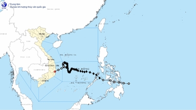
The storm's trajectory forecast shows that Typhoon No. 15 changed direction at times, causing the area of strong winds to expand. Photo: Vietnam Disaster Monitoring System.
Over the next 24-48 hours, the storm is likely to intensify. By 7 AM tomorrow (November 27th), the storm will be located in the central part of the South China Sea, approximately 170km north of Song Tu Tay Island, and is forecast to reach intensity level 10, with gusts up to level 13. After that, the storm will begin to slow down and deviate towards the west-southwest.
As of 7:00 AM on November 28th, the storm is likely still located in the central part of the South China Sea, approximately 160km northwest of Song Tu Tay Island. At this time, the storm has reached its strongest intensity, level 11, with gusts up to level 14, and will continue to maintain this intensity until it approaches the coastal waters of Vietnam.
Notably, the storm is shifting slightly towards the west-northwest, causing the area of strong winds to expand over the next 2-3 days. Accordingly, areas affected by the storm will experience increasingly strong winds, reaching level 11, gusting to level 14, with waves 7-9 meters high and extremely rough seas. Vessels operating in these dangerous areas are likely to be affected by thunderstorms, tornadoes, strong winds, and high waves.
As the storm approaches land, it weakens due to the influence of cold air and low sea surface temperatures. However, the storm's circulation will still cause heavy rain in the South Central region. The meteorological and hydrological agency will continue to update information daily according to the storm's development.
Ships should be vigilant for strong winds and high waves.
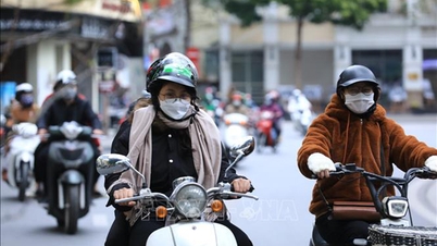
Along with the storm, the northern South China Sea continues to be affected by cold air with strong northeasterly winds of force 7, gusting to force 9. Island stations such as Bach Long Vi, Con Co, Ly Son, and Con Dao have recorded strong gusts of wind of force 7-9. On November 27-28, the northeasterly winds will strengthen to force 7-8, gusting to force 9-10, with waves reaching 5-7 meters in height and rough seas.

Forecasts indicate maximum wave heights of 4-6 meters on November 26th, particularly in the coastal waters from southern Quang Tri to Ca Mau . Photo: NCHMF.
In the coastal waters from southern Quang Tri to Ca Mau, and the western part of the South China Sea (including the western part of the Truong Sa Special Zone), from today onwards, there will be northeast winds of force 6-7, gusting to force 8-9; sea waves will be 4-6m high, and the sea will be rough.
From tonight, the Gulf of Tonkin will experience increasingly strong winds, reaching levels 6-7, gusting to levels 8-9, with rough seas and waves 2-4 meters high. All vessels operating in these areas are at high risk of being affected by strong winds and high waves.
Source: https://nongnghiepmoitruong.vn/bien-dong-co-bao-so-15-nhieu-vung-bien-song-lon-d786547.html
![[Photo] Capturing the moment the tide recedes at Yen Binh Son rapids - a million-year-old scenic spot in Quang Ngai.](https://vphoto.vietnam.vn/thumb/1200x675/vietnam/resource/IMAGE/2026/05/19/1779175463885_yen9-1199-jpg.webp)
![[Photo] General Secretary and President To Lam presides over a meeting on the implementation of Directive No. 34-CT/TW of the Party Central Committee.](https://vphoto.vietnam.vn/thumb/1200x675/vietnam/resource/IMAGE/2026/05/19/1779187768672_a1-bnd-2350-631-jpg.webp)
![[Photo] National Assembly Chairman Tran Thanh Man attends the groundbreaking ceremony for the National Highway 1A spatial axis project.](https://vphoto.vietnam.vn/thumb/1200x675/vietnam/resource/IMAGE/2026/05/19/1779161360398_ndo_br_bnd-1412-jpg.webp)


![[Photo] General Secretary and President To Lam receives Indian Defense Minister Rajnath Singh](https://vphoto.vietnam.vn/thumb/402x226/vietnam/resource/IMAGE/2026/05/19/1779184046302_anh-man-hinh-2026-05-19-luc-16-46-58.png)


Comment (0)