
 |
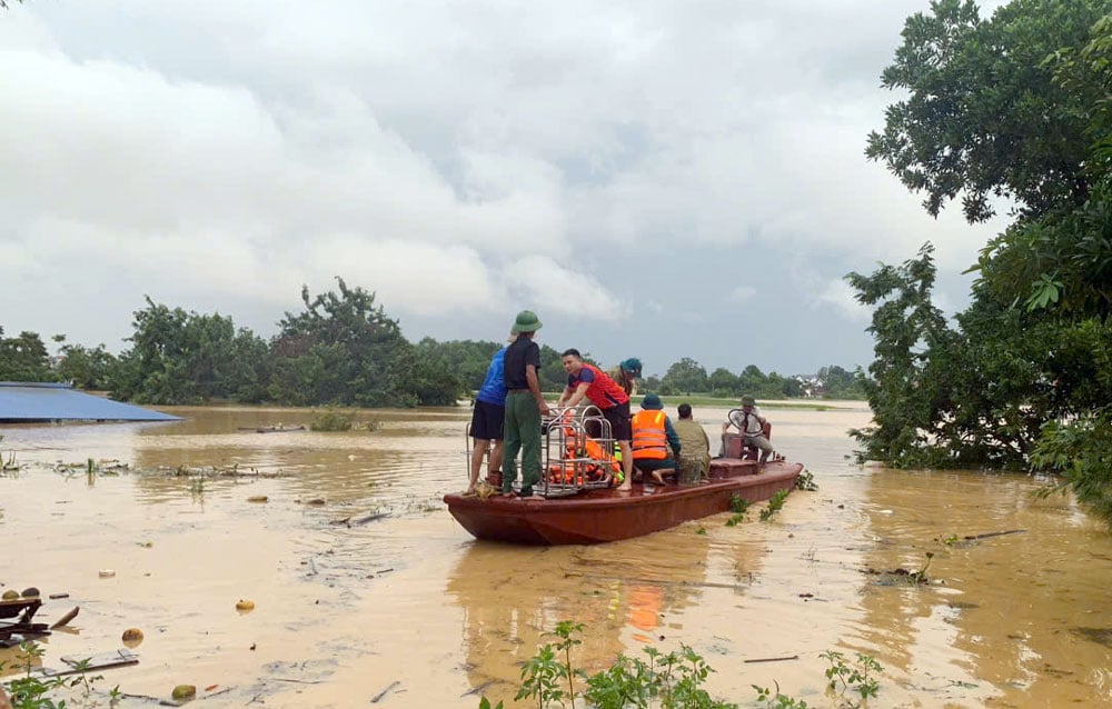
| Widespread flooding in many areas still occurs. |
In the next 6 hours, there will still be no rain in the province. However, due to the long period of heavy rain, the soil moisture has been saturated, the flood on many rivers has receded but is still at a high level, especially in the lower reaches of the Cau River, the water level is still high (at Gia Bay hydrological station at 11:00 am at 26.84m, below alert level 3 and is gradually receding; at Cha it is 12.02m, above alert level 3 at 2.02m), so there is still a high risk of landslides and land subsidence even when there is no rain.
In the next 12-24 hours, there is a risk of landslides and land subsidence on slopes, positive slopes in residential areas, traffic routes, riverbank landslides, and areas with construction works under construction.
In particular, deep flooding occurred over a large area in many areas of communes and wards, such as: Phan Dinh Phung, Gia Sang, Tich Luong, Linh Son, Quan Trieu, Phu Luong, Quang Son, Dong Hy, An Khanh, Yen Trach, La Hien, Nghinh Tuong, Nam Hoa, Trung Hoi, Van Han, Phu Dinh, Trung Hoi, Dong Hy, Dai Phuc, Than Sa, Binh Thanh, Trai Cau, Dai Tu, Phu Lac, Lam Vy, Dan Tien, Van Xuan, Pho Yen, Diem Thuy, Phu Binh, Kha Son, Phu Binh...
Widespread flooding in communes and wards downstream of Gia Bay hydrological station will last for the next 3-4 days and the flooding depth will gradually decrease at a rate of about 5-12cm/hour.
Warning level of natural disaster risk due to landslides, land subsidence due to rain, floods or water flow at Level 1
Warning of the impact of landslides and land subsidence due to heavy rain, floods or water flow: Landslides and land subsidence can threaten people's lives; cause local traffic congestion, affect the movement of vehicles; destroy or damage houses, civil and economic works, causing damage to production and socio-economic activities.
Source: https://baothainguyen.vn/tin-moi/202510/canh-bao-nguy-co-sat-lo-dat-ngap-ung-o-nhieu-dia-phuong-be956e1/
![[Photo] Prime Minister Pham Minh Chinh chairs a meeting of the Government Standing Committee on overcoming the consequences of natural disasters after storm No. 11](https://vphoto.vietnam.vn/thumb/1200x675/vietnam/resource/IMAGE/2025/10/09/1759997894015_dsc-0591-jpg.webp)

![[Photo] General Secretary To Lam visits Kieng Sang Kindergarten and the classroom named after Uncle Ho](https://vphoto.vietnam.vn/thumb/1200x675/vietnam/resource/IMAGE/2025/10/09/1760023999336_vna-potal-tong-bi-thu-to-lam-tham-truong-mau-giao-kieng-sang-va-lop-hoc-mang-ten-bac-ho-8328675-277-jpg.webp)

![[Photo] President Luong Cuong attends the 80th Anniversary of the Traditional Day of Vietnamese Lawyers](https://vphoto.vietnam.vn/thumb/1200x675/vietnam/resource/IMAGE/2025/10/09/1760026998213_ndo_br_1-jpg.webp)


Comment (0)