
 |
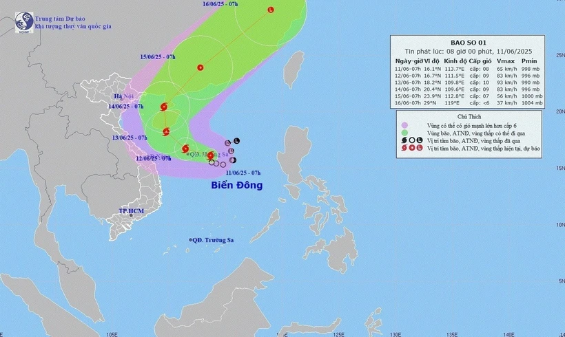
| Direction of movement of storm number 1. |
The eye of the storm is at about 16.1 degrees north latitude, 113.7 degrees east longitude, in the sea east of the Hoang Sa archipelago, the strongest wind near the eye of the storm is level 8 (62-74km/h), gusting to level 10, moving slowly in the west-northwest direction, speed 5-10km/h. Forecast until 7:00 a.m. on June 12, the eye of the storm is at about 16.7 degrees north latitude, 111.6 degrees east longitude, in the Hoang Sa archipelago; the storm moves in the west-northwest direction at about 10km/h and is likely to strengthen, wind force level 9, gusting to level 11. Dangerous area from 14.5-18.5 degrees north latitude, from 110-115.5 degrees east longitude; disaster risk level is level 3: Northern East Sea area (including Hoang Sa archipelago).
At 7:00 a.m. on June 13, the center of the storm was at about 18.2 degrees north latitude, 109.8 degrees east longitude, in the southern area of Hainan Island (China); moving northwest, about 10-15km/h and likely to strengthen; wind force level 10, gust level 13. Dangerous area from 15-20 degrees north latitude, from 109-113 degrees east longitude; disaster risk level is level 3: Northern East Sea area (including Hoang Sa archipelago) and offshore waters from Quang Tri to Quang Ngai , waters east of Bac Bo Gulf area.
At sea, the northern East Sea (including Hoang Sa archipelago), the northern central East Sea area has thunderstorms and strong winds of level 6-7, then increasing to level 8-9, gusting to level 11, waves 2.5-4.5m high, very rough seas. The southern central East Sea area, the southern East Sea (including Truong Sa archipelago) has strong southwest winds of level 6, sometimes level 7, gusting to level 8-9, waves 2-4m high, rough seas. Danger for ships due to thunderstorms, whirlwinds, strong winds and big waves.
According to the Department of Hydrometeorology, National Center for Hydrometeorological Forecasting, from 10pm on June 10 to 1am on June 11, the areas of Phu Yen, Kon Tum provinces and Hue city will have moderate to heavy rain. In Ca Lui 62.4mm, Phuoc Tan 46.8mm (Son Hoa district)... It is forecasted that in the next hours, the areas of Phu Yen, Kon Tum provinces and Hue city will continue to have rain with accumulated rainfall ranging from 30-60mm, in some places over 90mm.
In Phu Yen , there is a warning of the risk of flash floods on small rivers and streams, landslides on steep slopes in Dong Xuan, Phu Hoa, Son Hoa, Song Hinh and Tay Hoa districts. The warning level of natural disaster risk due to flash floods, landslides, and land subsidence due to heavy rain or water flow is level 1.
Source: https://baophuyen.vn/xa-hoi/202506/canh-bao-nguy-co-xay-ra-lu-quet-tren-cac-song-suoi-nho-4971de3/


Comment (0)