
In order to transform the banks of the Han River into an urban center and a gateway for riverside tourism , Da Nang has planned the area as a green space with artistic lighting for the buildings.
More than 20 years ago, the Han River was a messy sight, marked by numerous stilt houses, with the banks separated, forcing residents to take ferries 400-600 meters across. In 1997, when Da Nang became a centrally governed city, its leaders and people contributed money to build a swing bridge, allocate resettlement land, and construct apartment buildings for thousands of households living in boats and stilt houses.
Urban renovation has transformed the Han River, likened to a silk ribbon draped across the city center. To live up to its status as a modern city, at the end of 2023, the Da Nang City People's Committee approved the zoning plan for the Han River embankment and eastern bank, at a scale of 1/2,000, aiming to "renovate" the river and create urban landmarks on both banks.

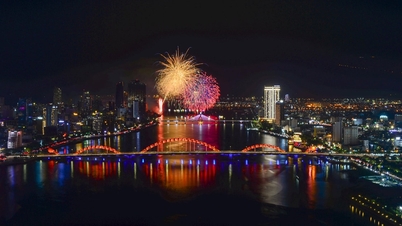
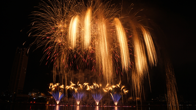
The Han River sparkled during the 2023 fireworks competition. Photo: Nguyen Dong
With a planned area of approximately 6,675 hectares encompassing Hai Chau, Son Tra, Thanh Khe, Ngu Hanh Son, and Cam Le districts, the Han River waterfront and eastern bank area will be the urban center, the administrative and political center; the gateway to riverside and coastal tourism; the national and international convention center; the financial, education and high-quality training center of Central Vietnam; and the cultural, sports, and healthcare center.
The city will create open spaces, combining water features, green corridors along the river, and large parks. Public buildings and services will connect with the river and the sea, creating a harmonious, ecological natural space. Along the eastern bank of the Han River, the city plans parks and squares connected by tree-lined avenues and pedestrian walkways.
The Dien Hai Citadel area, the remains of the first fortifications resisting the French in 1858, and the Da Nang Museum have been approved for planning as a central square. This core area will be the venue for the city's cultural and political activities, serving the recreational and historical learning needs of residents and tourists.

The area around the museum and administrative center of Da Nang City has been planned as a central square. Photo: Nguyen Dong
Key features of the urban space will include a living museum in Hai Chau district showcasing the history and urban lifestyle of Da Nang; a commercial center in Son Tra district with the aim of forming a new economic hub for the city. In addition, there will be a commercial and tourism space comprising the existing streets with Con Market, Han Market, and tourist service areas on the eastern bank...
According to Phung Phu Phong, Director of the Da Nang Department of Construction, the city approved this zoning plan to provide a basis for implementing detailed plans and to resolve legal issues for investors whose projects along the Han River and east bank are currently stalled. "The Han River and east bank zoning plan is the most important of the nine zoning plans for Da Nang in the period 2021-2030, with a vision to 2050," Mr. Phong said.
The city is also studying the "River of Light" project, an artistic initiative connecting five bridges across the river, with a budget of nearly 400 billion VND. According to Mr. Phong, high-rise buildings along the Han River will be illuminated artistically, harmonizing with the overall design. In the future, high-rise buildings springing up along the riverbank will have to invest in additional artistic lighting. "This is a way to create a ribbon of light along the Han River," Mr. Phong explained.
In this Han River planning project, the city aims to upgrade the green spaces and landscapes along Bach Dang, Tran Phu, and Tran Hung Dao streets to serve tourism. Currently, Da Nang's public green space (including parks and gardens) only reaches 2.64 m2/person. According to urban classification regulations, public green space in the inner city of a Type I city like Da Nang must reach 5 m2/person to be awarded 1.5 points; 6 m2/person is awarded 2 points.
Architect Ngo Viet Nam Son suggested that when implementing the Han River zoning plan, the city should allocate a large area for green spaces, as this is something Da Nang severely lacks. This would include green spaces on both sides of the river and green squares. The islets should also be preserved to provide habitats for the increasingly numerous migratory birds that flock to the Han River.

Architect Ngo Viet Nam Son. Photo: Nguyen Dong
Architect Son also suggested that Da Nang should have a plan to create green spaces on both sides of the river for pedestrians, cyclists, and public transport users. "That means having public transport on both the east and west banks, connecting them. Residents and tourists going to the city center wouldn't need private vehicles anymore; they could use public transport. This would make the space along the Han River more vibrant," he said.
Mr. Son also suggested that Da Nang should create a system of waterway taxis, running like buses from one dock to another and moving continuously so that residents and tourists can enjoy boat trips on the river and admire the scenery on both banks. If this is implemented, activities on the Han River will be more attractive and alleviate traffic congestion in the city center.
Another point to note, according to Mr. Son, is that the planning "should not divide the land into separate plots." The city has already granted permits for many projects encroaching on the river, so if encroachment has already occurred, houses should not be built. Instead, green spaces and public and cultural facilities such as museums, theaters, and libraries should be created so that the two sides of the Han River are like the city's living room, always clean and beautiful to welcome tourists.
Source link


Comment (0)