
Specifically, the common accumulated rainfall in Dak Lak is from 20-40mm, some places over 60mm; Khanh Hoa from 10-30mm, some places over 40mm; Lam Dong from 5-10mm, some places over 20mm.
Warning of the risk of flash floods on small rivers and streams, landslides on steep slopes in many communes/wards of Dak Lak province including: Cu M'ta, Duc Binh, Ea Rieng, Binh Kien, Tuy Hoa, Song Hinh, Van Hoa; Cu Yang, Ea Pal, Hoa My, Hoa Xuan, Dong Hoa, Phu Hoa 1, Phu Hoa 2, Son Thanh; Cu Prao, Cu Pui, Dang Kang, Ea Ba, Ea Kar, Ea Knop, Ea Ly, Ea O, Ea Trang, Krong A, M'Drak, Song Cau, Xuan Dai, Son Hoa, Suoi Trai, Tan Tien, Tay Son, Tuy An Bac, Tuy An Nam, Vu Bon, Xuan Canh, Xuan Loc, Xuan Tho, Yang Mao.
In Khanh Hoa province, communes and wards at risk of flash floods and landslides include: Bac Ninh Hoa, Dai Lanh, Dien Dien, Hoa Tri, Khanh Vinh, Nam Ninh Hoa, Dong Ninh Hoa, Ninh Hoa, Tu Bong, Van Hung, Van Ninh, Van Thang; Bac Ai Dong, Cam Hiep, Cam Lam, Cong Hai, Ba Ngoi, Bac Nha Trang, Hoa Thang, Suoi Dau, Tan Dinh, Tay Ninh Hoa, Thuan Bac, Cam An, Dien Khanh, Dien Lac, Dien Lam, Dien Tho, Dong Khanh Son, Khanh Son, Nam Cam Ranh, Nam Khanh Vinh, Bac Cam Ranh, Cam Linh, Cam Ranh, Nam Nha Trang, Nha Trang, Tay Nha Trang, Suoi Hiep.
For Lam Dong, communes and wards at risk of flash floods and landslides include: Lac Duong; Dam Rong 4, Don Duong, D'Ran, Duc Trong, Ka Do, Krong No, Nam Da, Nam Nung, Ninh Gia, Lam Vien - Da Lat, Lang Biang - Da Lat, Xuan Huong - Da Lat, Xuan Truong - Da Lat, Quang Lap, Quang Phu, Suoi Kiet, Ta Hine, T Nang, Tan Minh, Tanh Linh.
Level of natural disaster risk due to flash floods, landslides, land subsidence due to heavy rain or water flow level 1; Dak Lak and Khanh Hoa level 2.
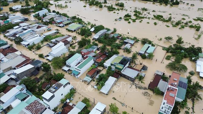
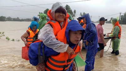
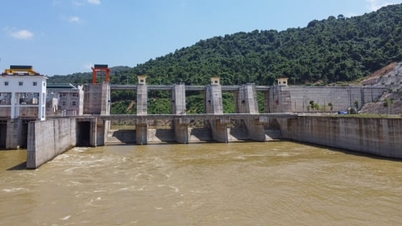
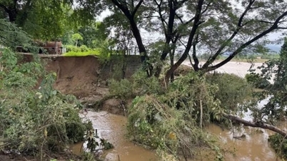
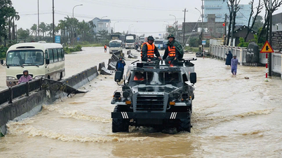
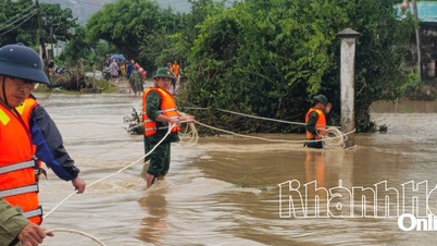
Flash floods and landslides can have very negative impacts on the environment, threaten people's lives; cause local traffic congestion, affect the movement of vehicles; destroy civil and economic works, causing damage to production and socio-economic activities.
The hydrometeorological agency recommends that local authorities pay attention to reviewing bottlenecks and vulnerable locations in the area to have prevention and response measures.
Along with that, information about high tides in the eastern coastal area of the South, the National Center for Hydro-Meteorological Forecasting stated that the highest water level of the day in the eastern coastal area of the South tends to increase gradually, the highest tide peak from the evening of November 21 to November 22, 2025 at Vung Tau station is likely to reach 4.15 - 4.20m at 1:00 - 3:00 and 14:00 - 17:00.
It is forecasted that from January 22-23, the highest water level of the day in the eastern coast of the South will tend to change slowly, the highest tide of the day at Vung Tau station is likely to reach 4.15 - 4.25m.
Level 1 flood disaster risk warning.
Hydrological experts warn: This is a high tide period, forecast to last until November 24. The eastern coastal area of the South needs to be on guard against the high risk of flooding and dike overflow in low-lying coastal and riverside areas. In addition, high tides also affect transportation, agricultural production, aquaculture, water pollution and people's lives.
Source: https://baotintuc.vn/xa-hoi/de-phong-lu-quet-sat-lo-dat-khu-vuc-cac-tinh-dak-lak-khanh-hoa-va-lam-dong-20251121192737783.htm
![[Photo] Visit Hung Yen to admire the "wooden masterpiece" pagoda in the heart of the Northern Delta](/_next/image?url=https%3A%2F%2Fvphoto.vietnam.vn%2Fthumb%2F1200x675%2Fvietnam%2Fresource%2FIMAGE%2F2025%2F11%2F21%2F1763716446000_a1-bnd-8471-1769-jpg.webp&w=3840&q=75)

![[Photo] General Secretary To Lam receives President of the Senate of the Czech Republic Milos Vystrcil](/_next/image?url=https%3A%2F%2Fvphoto.vietnam.vn%2Fthumb%2F1200x675%2Fvietnam%2Fresource%2FIMAGE%2F2025%2F11%2F21%2F1763723946294_ndo_br_1-8401-jpg.webp&w=3840&q=75)
![[Photo] National Assembly Chairman Tran Thanh Man holds talks with President of the Senate of the Czech Republic Milos Vystrcil](/_next/image?url=https%3A%2F%2Fvphoto.vietnam.vn%2Fthumb%2F1200x675%2Fvietnam%2Fresource%2FIMAGE%2F2025%2F11%2F21%2F1763715853195_ndo_br_bnd-6440-jpg.webp&w=3840&q=75)
![[Photo] President Luong Cuong receives Speaker of the Korean National Assembly Woo Won Shik](/_next/image?url=https%3A%2F%2Fvphoto.vietnam.vn%2Fthumb%2F1200x675%2Fvietnam%2Fresource%2FIMAGE%2F2025%2F11%2F21%2F1763720046458_ndo_br_1-jpg.webp&w=3840&q=75)


Comment (0)