
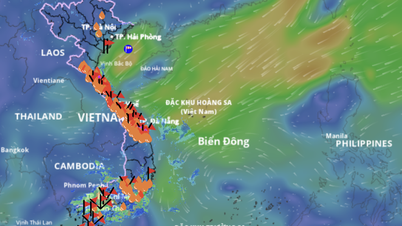
Updated at 6 p.m. on July 22 from the National Center for Hydro-Meteorological Forecasting: Storm No. 3 is still in place. The storm's center is currently located on the mainland of Ninh Binh and Thanh Hoa provinces, at coordinates of about 20.1 degrees North latitude and 105.7 degrees East longitude. The strongest wind near the storm's center is at level 8, gusting to level 10. In the next 3 hours, the storm will hardly move. Meteorological experts say this is a rare phenomenon.
Previously, at 5 p.m. on July 22, storm No. 3 had not yet dissipated despite having moved deep into the mainland since noon of the same day. The National Center for Hydro-Meteorological Forecasting has just released updated information on the development of this storm.
")
Some sources previously said that the storm had weakened into a tropical depression, but according to the Vietnam Meteorological Agency, the storm still exists at level 8 intensity, gusting to level 10. The center of the storm at 4 p.m. was at about 20.1 North latitude - 105.9 East longitude, on the mainland of Ninh Binh - Thanh Hoa provinces.
Over the past 3 hours, the storm has remained almost stationary. Strong winds of level 7-8 continue to be recorded in many places.
Specifically, Hon Dau ( Hai Phong ): level 8, jerk level 10; Uong Bi (Quang Ninh): level 7, jerk level 8; Van Ly (Ninh Binh): level 8, jerk level 10; Ba Lat (Hung Yen): level 7, jerk level 9...

The National Center for Hydro-Meteorological Forecasting forecasts that in the next 24 hours, the storm will continue to move in a West-Southwest direction at a speed of 10-15km/hour, enter the Upper Laos region and gradually weaken into a tropical depression, then a low pressure area.
However, the danger zone still covers the northern region from latitude 18.5 and the western region of longitude 108. The disaster risk level remains at level 3 for the area from Quang Ninh to Nghe An.
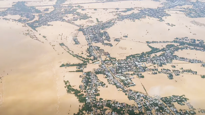
Previously, from the night of July 21 to July 22, storm No. 3 (Wipha) caused many prolonged heavy rains in many localities in the southern part of the Northern Delta and especially the North Central region (Thanh Hoa and Nghe An).
In Quang Ninh province, a fishing boat capsized while taking shelter from the storm in the Chanh River area (Quang Yen ward), the 4 crew members on board were brought safely to shore. However, the Ha Long area suffered almost no significant damage.

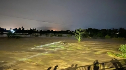
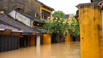
On the contrary, some roads in Ninh Binh, Thanh Hoa, and Hai Phong were deeply flooded. In particular, areas such as Nghia Thanh and Nghia Hung (Ninh Binh) were heavily rained, causing water to overflow onto the roads, disrupting traffic.
According to the Steering Committee for Natural Disaster Prevention and Control of Tay Yen Tu Commune (Bac Ninh Province), 4 landslides appeared on provincial roads 291, 293 and the inter-commune road (from Tay Yen Tu to Tuan Dao), causing complete traffic jams. 32 households living near the dangerous area have been evacuated.
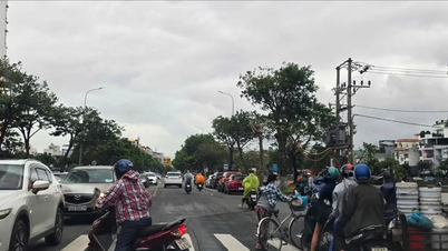
In Hanoi, people are limiting their trips out for fear of storms, while at markets and supermarkets, the number of people buying meat, fish, and vegetables has increased sharply due to storm news.
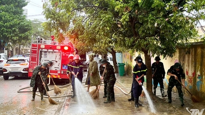
 were clean on the morning of July 22. Photo: HUYNH ANH")
Before that, every citizen, agency, unit, business... was ready to respond to storm No. 3. Hundreds of cars of residents in Phu Dien ward were taken out of the basement, temporarily gathered in the square, under the bridge and showrooms - creating makeshift "storm shelters", especially in the area of Pham Van Dong street.
The management board of an apartment complex with more than 2,000 households in Phu Dien ward said they have proactively parked cars in the front yard to prevent the risk of falling trees or flying objects hitting cars.
However, from morning to noon on July 22, Hanoi was still quiet... as usual, it was raining lightly but the wind was calm.

By early afternoon, many places in Hanoi, Bac Ninh, Thai Nguyen… were still surprisingly sunny. Therefore, many people tried to go to work, go to the market to make use of half a day of work, but at around 3 pm, dark clouds rolled in, and the wind started to howl again.
Since around 5pm, the rain and wind in Hanoi have stopped. On social media, many reports said that the storm has dissipated.

According to meteorological experts, the area of strong wind and rain is mainly concentrated in Thanh Hoa and Nghe An, that is, on the southern edge of the storm's eye.
Source: https://www.sggp.org.vn/den-19-gio-ngay-22-7-bao-so-3-van-ton-tai-hien-tuong-la-post804942.html


![[Photo] Prime Minister Pham Minh Chinh chairs the second meeting of the Steering Committee on private economic development.](https://vphoto.vietnam.vn/thumb/1200x675/vietnam/resource/IMAGE/2025/11/01/1762006716873_dsc-9145-jpg.webp)


Comment (0)