
To realize this orientation, many ideas for planning the alluvial plains and sandbars of the Red River have been put forward in recent times, aiming to add public spaces, make good use of cultural and landscape elements, ensure flood control, and respect the development of the natural ecosystem.
Harmonious urban development on both sides of the river.
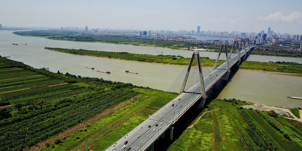
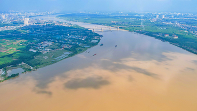
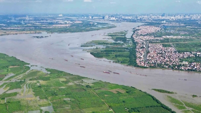
With an area of approximately 23 hectares, the sandbar in the middle of the Red River is a large green space under the administrative boundaries of Hoan Kiem, Tay Ho, Ba Dinh, and Long Bien districts. Recently, the Hanoi Capital City Planning for the period 2021-2030, with a vision to 2050, and the General Planning for the Construction of Hanoi Capital City until 2045, with a vision to 2065, were approved by the Government .
In these two plans, the Red River is identified as one of the five important spatial axes in the development of the capital city, with a development orientation focused on green spaces and landscapes in the city center, and harmonious urban development on both sides of the river.
At the same time, Article 17 of the 2024 Capital City Law also stipulates that resources should be concentrated and priority given to the implementation of the Red River Sub-division Plan in accordance with the Capital City Plan and the General Capital City Plan; Hanoi City is allowed to build a cultural and industrial center on the Red River floodplains and other areas with advantageous locations and cultural spaces in accordance with the plan…
According to experts, the planning guidelines and regulations in the Capital City Law truly serve as a foundation for making the Red River a distinctive highlight of Hanoi in the future. The Red River will become a green space axis, attractive not only within the areas on both sides of the river but also with a ripple effect, creating momentum for the development of Hanoi to the North, East, Northeast, and South.
Chairman of the Vietnam Urban Planning and Development Association, Tran Ngoc Chinh, shared that researching and transforming the sandbanks and alluvial plains of the Red River into a cultural and tourism park for the capital city is a groundbreaking solution to effectively exploit land resources and the potential advantages and natural beauty of the Red River, creating open, green spaces that meet the needs of recreation, sports, and tourism, attracting visitors, and solving the problem of a lack of public spaces, especially cultural spaces and art exhibition spaces for the people of Hanoi.
The creation of amusement and cultural parks is an important and indispensable part of large cities, urban areas, and densely populated residential areas. This also helps to reduce violations of construction regulations, improve environmental sanitation, and increase the proportion of green space in historical inner-city areas.
Many creative ideas
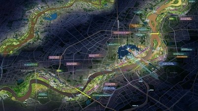
Under the direction of the Hanoi People's Committee, a competition for planning ideas for a multi-functional cultural park in the sandbar and riverside areas of the Red River, organized by four districts: Hoan Kiem, Ba Dinh, Long Bien, and Tay Ho, aims to find serious and dedicated research that will contribute to Hanoi's development of land resources and the diversification of the sandbar and riverside areas. This will contribute to the realization of the central Red River landscape axis plan.
In the competition, the "Green Crane Park" design carefully considered the ecological cycle; the changes in nature, especially the impact of the Red River's water level. Speaking with a reporter from the Economic & Urban Newspaper, architect Nguyen Duc Trung said: "After Typhoon Yagi, we can see that Hanoi urgently needs more green spaces in the Red River area. For this project, we have calculated all construction and infrastructure elements up to flood level 2, equivalent to a water level of 11.5m."
Meanwhile, a representative from the Green Lungs Hanoi consortium shared: "In our proposed plan, the entire low-lying area of the Red River mid-river will be used solely for growing crops, agricultural cultivation, and the construction of two-story stilt houses. The first floor will be an open space, usable when there is no flooding, and the second floor will be an enclosed space that can be used for living or storing belongings during floods."
Regarding the planning of the Red River axis, Dr. Phan Dang Son, Chairman of the Vietnam Association of Architects, stated that nearly 30 meticulously researched design proposals were submitted by reputable design firms and joint ventures both domestically and internationally. This demonstrates the strong response from architects and urban planners to the sandbars in the middle and along the banks of the Red River. Many proposals presented unique ideas, meeting Hanoi's desire to add public spaces, effectively utilize cultural and landscape elements, ensure flood control, and respect natural ecological development.
According to architect Phan Dang Son, the cultural park model would be suitable for the planning of the Red River's mid-river area, especially when situated within the Red River's rich cultural and historical space. The park would center around the Long Bien Bridge urban heritage site, using the Red River landscape as a backdrop, forming cultural spatial routes connecting with heritage sites on both banks and the entire Red River green corridor.
Dr. Nguyen Van Tuyen and Dr. Nguyen Thu Huong from Hanoi University of Civil Engineering also shared that the park in the middle of the Red River could be organized as a themed ecotourism park. The city needs to leverage its main potential in terms of landscape and unique ecological environment to create an ecological park linked to the development of semi-submerged forests, ecological nurseries, sandbanks, and water bodies. The ecological park, combined with the Long Bien Bridge heritage site, would become a spectacular cultural and ecological landscape of the capital, offering tourism activities such as picnics, exploration, ecological experiences, camping, and boating.
Clause 2, Article 14 of the Law on the Capital City clearly states: concentrate resources and prioritize the implementation of the Red River and Duong River zoning plans in accordance with the Capital City Plan and the General Capital City Plan; allow the construction of new dikes in accordance with the flood control plan for the river with dikes, the dike planning, and other relevant plans to effectively utilize land resources;
On the riverbanks, some existing residential areas are permitted to exist, and new construction of buildings and houses is allowed at an appropriate rate according to the flood control plan of the river with dikes and other relevant plans; the remaining riverbank and sandbar areas are permitted to have public spaces and public service facilities, but without raising the riverbank or sandbar to ensure that the flow of water is not obstructed.
Source: https://kinhtedothi.vn/quy-hoach-khong-gian-bai-giua-song-hong-diem-nhan-cua-do-thi-trong-tuong-lai.html


![[Photo] Enchanting ancient rose garden on the mountainside in Nghe An](/_next/image?url=https%3A%2F%2Fvphoto.vietnam.vn%2Fthumb%2F1200x675%2Fvietnam%2Fresource%2FIMAGE%2F2025%2F12%2F19%2F1766109900916_vuon-hong-chin-do-thu-hut-du-khach-toi-check-in-o-ha-noi-3-20162778-1671624890024-1671624890104198100259.jpeg&w=3840&q=75)
![[Photo] General Secretary To Lam visits the exhibition space showcasing books, photo exhibitions, and achievements of digital transformation in journalism.](/_next/image?url=https%3A%2F%2Fvphoto.vietnam.vn%2Fthumb%2F1200x675%2Fvietnam%2Fresource%2FIMAGE%2F2025%2F12%2F19%2F1766110879215_1766110240024-jpg.webp&w=3840&q=75)


Comment (0)