

From the high mountains, traversing over a hundred kilometers, the Tra Khuc River meanders gently to its mouth; on the right bank, it opens its heart to receive more water from the Ve River, while on the left bank, it divides a portion of the river, sending water north to the Sa Ky estuary, forming the Kinh River, which stretches across the My Khe - An Chuan coastline. For generations, the people of Tinh Khe have called the Kinh River the "Front River," because it runs in front of houses and fields, unlike the "Back River," the Diem Dien River, which encircles the peaceful villages behind.

Hue Duong Vien Beer
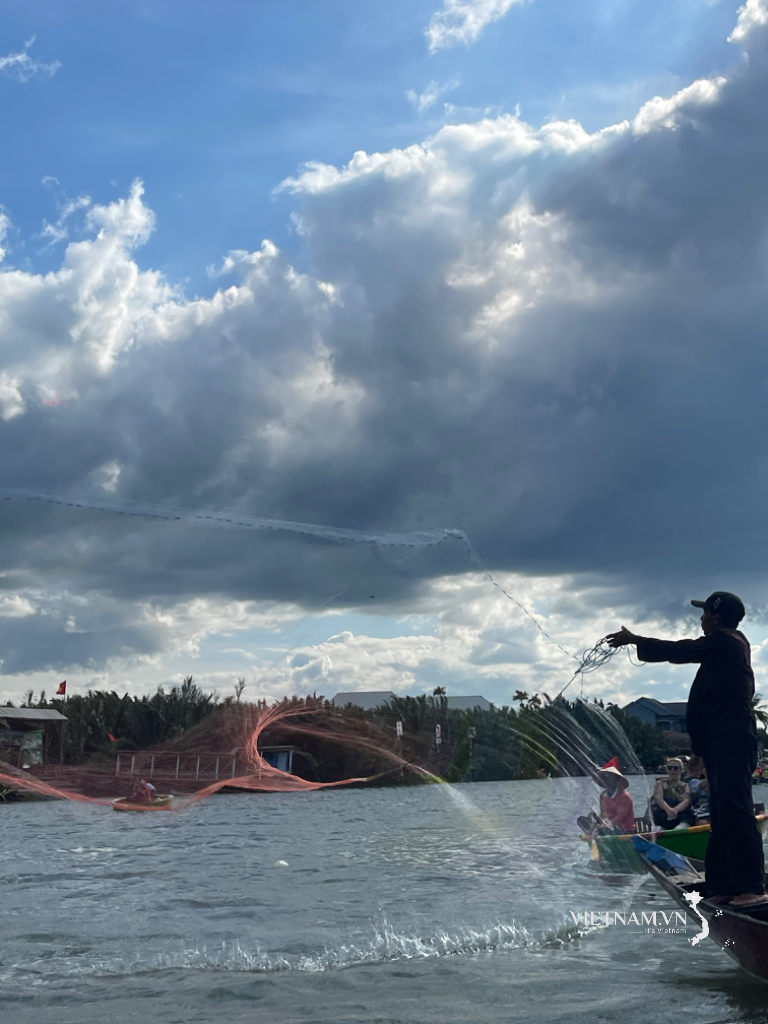
Just over ten kilometers long, the Kinh River is breathtakingly beautiful. Moreover, this river, with its dense mangrove forests lining both banks, is associated with many famous historical events and figures, and was once an impregnable base for the army and people of Quang Ngai during the resistance war against the US, saving the nation.
Let's begin at the Kinh River estuary, located west of Co Lu village (Tinh Khe commune), on a summer morning, if you are a tourist . Here, to the east is the sea with its brightly colored fishing rafts at dawn. Far in the distance, slightly to the northeast, is the Ba Lang An (Batangan) cape jutting out into the sea. Further away, dimly visible through the mist and waves, is Ly Son Island - the homeland of the Hoang Sa Fleet. Turning south, the vast Dai estuary appears before you, with fishing boats returning after a night at sea. Behind you, to the west, are Thien Ma Mountain, Dau Voi Mountain, and further in the distance are Thien An Mountain, Long Dau Mountain, and Tran Cong Mountain; stretching into the far horizon is the majestic Truong Son mountain range. River and sea, clouds and sky, nature seems to harmonize to display a landscape that is both familiar and strange, captivating the heart.
A small boat will take you down the Kinh River towards Sa Ky port, passing through lush green mangrove forests. When you see the shadow of an ancient banyan tree cast over the river, you've passed My Lai village. Beneath that banyan tree, a stone stele has stood for over a century and a half. The three Chinese characters "Hue Duong Vien" (惠養园) inscribed on the stele tell us that the garden, located just a few steps from the Kinh River bank, was granted by Emperor Tu Duc to Tuy Thanh Duke Truong Dang Que (1793 - 1865) when the virtuous official came here to retire in his final days. The Truong family, with figures such as Truong Dang Do, Truong Dang Que, Truong Quang Dan, and Truong Van De (Quang De), is connected to a familiar folk song of the Kinh River region, like a prophecy:
When will the Pegasus cross the river?
Then the village of Mỹ Lại had no nobles or high-ranking officials.
(Folk songs of Quang Ngai)
My Lai - Kinh River is the hometown of Admiral Truong Dang Do (? - 1802) of the Tay Son Dynasty, who, along with his wife, General Nguyen Thi Dung, committed suicide in Bac Giang around mid-June of the year Nham Tuat (1802). The remains of this heroic couple were later brought back to their hometown by their nephew, Truong Dang Que, during the reign of Emperor Minh Mang. Currently, the ancestral tablets of Truong Dang Do and Nguyen Thi Dung are worshipped at the Truong Tieu Tong temple, located a few dozen meters from the Kinh River bank.
The canal has flowed through the ups and downs of history.
Looking at the scenery of the Kinh River now, with its banks lined with lush coconut trees and fruit-bearing coconuts, along with fishing boats and docks, few would imagine that this was once a man-made canal.

The Kinh River flows through My Lai village (Tinh Khe commune, Quang Ngai city).
From approximately the 16th to the 19th centuries, waterway trade in the Quang Nam - Quang Ngai - Binh Dinh - Phu Yen region gradually developed along with the formation of a community of merchants, most of whom were of Chinese origin.
To facilitate travel and transportation of goods between Sa Ky and Co Luy estuaries (and vice versa), the ancients created a waterway along the coast, connecting existing lagoons and taking water from the Tra Khuc River at Co Luy estuary to flow to Sa Ky estuary, passing through the villages of Co Luy and My Lai (now part of Tinh Khe commune) before flowing to An Chuan (Tinh Ky). The waterway was sufficient for boats to travel up and down the river year-round, regardless of sun or rain, and there were no underwater rocks or strong winds. Goods and forest products from the Ba To and Minh Long sources flowed downstream along the Ve River, while goods from the Son Ha source flowed along the Tra Khuc River to Co Luy estuary. Goods from the Tra Bong (Da Bong) source flowed along the Tra Bong River to Sa Can estuary, and from Sa Can, by sea (during calm seasons) or by land (during stormy seasons) to Sa Ky port, continuing along the Kinh River to Co Luy.
By the mid-20th century, the Kinh River had almost completely lost its role as a waterway for transportation due to the development of the North-South railway and road network. Fishery activities in the Kinh River, following natural processes, became the main source of income for a segment of the population in Tinh Khe and Tinh Hoa communes.
On July 18, 2024, the People's Committee of Quang Ngai province issued a decision recognizing Tinh Khe Mangrove Forest (Tinh Khe commune, Quang Ngai city) as a tourist destination of the province. (to be continued)
Source: https://thanhnien.vn/ke-chuyen-dong-song-xu-quang-hao-kiet-ben-dong-kinh-tho-mong-185241119212607902.htm


![[Photo] Coc Ly market bustling on the eve of Tet](https://vphoto.vietnam.vn/thumb/402x226/vietnam/resource/IMAGE/2026/02/14/1771062261424_baolaocai-br_img-6457-jpg.webp)


Comment (0)