
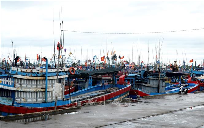
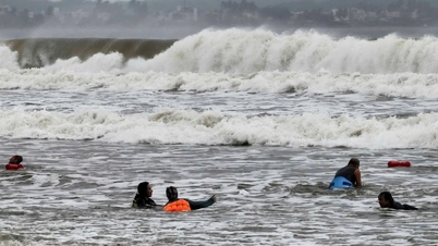
At Sa Ky estuary, the border area between Dong Son and Tinh Khe communes ( Quang Ngai province), Border Guard Squadron 2 organized the firing of storm warning flare No. 12. The red flares were directed towards the sea, transmitting an emergency signal to hundreds of ships operating at sea, about the appearance of the storm and the risk of dangerous waves and winds approaching.
Signal flares not only help local fishermen but also out-of-province and out-of-contact vessels easily locate the estuary to find shelter; at the same time, they are also an early warning for coastal residents to proactively reinforce their houses, prepare for natural disasters, and minimize damage to people and property when storms make landfall.
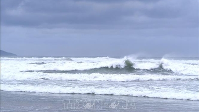
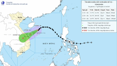
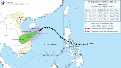
According to the National Center for Hydro-Meteorological Forecasting, at 7:00 a.m. on October 21, the center of storm Fengshen (storm No. 12) was about 130 km north of Hoang Sa special zone, with a strong intensity of level 9-10, gusting to level 12. It is forecasted that from this morning to this afternoon, the storm will continue to increase in intensity before interacting with cold air.
From around this evening, October 21, the storm began to interact with the cold air mass, changing direction to move west-southwest at a speed of about 10-15 km/h and gradually weakening. At 7:00 a.m. on October 22, when operating in the western sea of Hoang Sa (Vietnam), about 220 km east-northeast of Da Nang , the storm was at level 9, gusting to level 11.
During the day and night of October 22, the storm moved mainly in the West - Southwest direction, traveling about 10km per hour and gradually weakened into a tropical depression, then a low pressure area, entering the mainland of Da Nang - Quang Ngai. By 7am on October 23, the center of the low pressure area on the mainland of Da Nang - Quang Ngai was still below level 6.
In Quang Tri province, to respond to storm No. 12 causing heavy rain, risk of local flooding and landslides, the province requested units and localities to deploy response plans according to the "4 on-site" motto.
The province requests the People's Committees of coastal communes and wards and Con Co Special Zone to coordinate with the Provincial Border Guard Command, the Department of Agriculture and Environment, and the Quang Tri Maritime Port Authority to urgently count all local vessels and vehicles operating at sea and along the coast. At the same time, coordinate with relevant agencies, by all means, promptly inform ship owners and captains about the developments and forecast of the storm's movement; guide them to move out or not to enter the danger zone in the next 24 hours. Organize calls and guide vessels and vehicles to safe shelters; support the implementation of necessary measures to ensure the safety of vessels at anchorages.
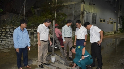
The Department of Agriculture and Environment and the Border Guard Command, according to their functions and tasks, direct the Management Boards of fishing ports, anchorage areas, border posts and stations to be on duty 24/7 at ports, wharves and anchorage areas to coordinate in counting and guiding ships to anchor safely, and to be ready with rescue forces when situations arise.
In response to heavy rains that pose a risk of flooding, landslides, and flash floods, organize a thorough review and inspection of areas at high risk of flooding, inundation, and landslides, especially in mountainous areas, along rivers and streams, urban areas, low-lying residential areas, and unfinished construction projects. Pay special attention to areas that have experienced heavy rains in recent days such as Khe Sanh, Ta Rut, Huong Phung, Dakrong, Kim Ngan, etc.; areas at high risk of landslides such as Tuyen Son, Tuyen Phu, Tuyen Lam, Bo Trach, Huong Lap, Huong Phung, Khe Sanh, etc.; low-lying areas that are often deeply flooded such as Dien Sanh, Nam Hai Lang, Le Thuy, Ninh Chau, Quang Ninh, etc.; and urban areas at risk of flooding such as Dong Ha, Nam Dong Ha, Quang Tri, Dong Hoi, Dong Thuan, etc.;
Localities should proactively inspect, review, and arrange forces and means to control and guide traffic in flooded, inundated, and isolated areas; support evacuation when necessary. Grasp the situation of people in affected areas to call for safe places, resolutely not allowing people and vehicles to pass through areas with deep flooding, fast-flowing water or high risk of landslides and flash floods; In addition, localities need to proactively take measures to drain water to prevent flooding, protect production, business, urban areas, and residential areas. Instruct people on measures to protect agricultural production areas, crops, livestock, and aquaculture.
Due to the influence of the tropical convergence zone with its axis passing through the Central region connecting with the center of storm No. 12 and disturbances of the upper easterly wind zone, it is forecasted that in Quang Tri province from October 21 to 22, the average rainfall will be 40-70 mm, locally more than 100 mm.
In particular, from October 23-26, due to the strong strengthening of cold air combined with the Northwest circulation of storm No. 12, the circulation of cold air and disturbances of the high-altitude easterly wind zone, Quang Tri will experience a widespread heavy rain, with rainfall in the North of the province generally ranging from 200-350 mm in some places; in the South of the province generally ranging from 300-400 mm in some places over 500 mm.
Due to the recent heavy rains in the province, the amount of water in the ground is almost saturated, the water level in the reservoirs has also reached 85-90% of the design capacity. This heavy rain will cause floods on rivers such as: Gianh River is likely to be at alert level 2 to alert level 3, Kien Giang River reaches and exceeds alert level 3. In particular, the risk of landslides in key locations (points where landslides often occur) in mountainous areas and flooding in low-lying areas in urban areas is very high.
Source: https://baotintuc.vn/xa-hoi/khan-cap-keu-goi-tau-thuyen-vao-bo-tranh-tru-bao-so-12-20251021114114210.htm

![[Photo] Da Nang residents "hunt for photos" of big waves at the mouth of the Han River](https://vphoto.vietnam.vn/thumb/1200x675/vietnam/resource/IMAGE/2025/10/21/1761043632309_ndo_br_11-jpg.webp)
![[Photo] Prime Minister Pham Minh Chinh received Mr. Yamamoto Ichita, Governor of Gunma Province (Japan)](https://vphoto.vietnam.vn/thumb/1200x675/vietnam/resource/IMAGE/2025/10/21/1761032833411_dsc-8867-jpg.webp)

![[Photo] Prime Minister Pham Minh Chinh meets with Speaker of the Hungarian National Assembly Kover Laszlo](https://vphoto.vietnam.vn/thumb/1200x675/vietnam/resource/IMAGE/2025/10/20/1760970413415_dsc-8111-jpg.webp)


Comment (0)