

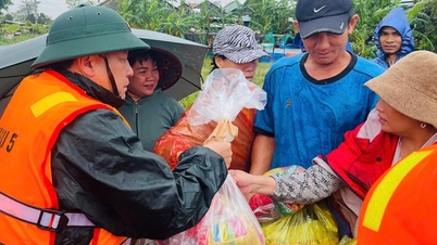
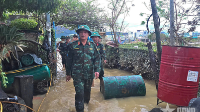
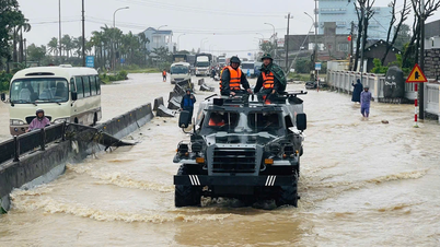
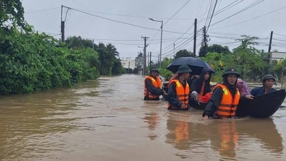
Armed forces urgently built a dam to prevent floods in Tuy Phuoc commune, Gia Lai province on the morning of November 19.
Emergency flood on Cai River Nha Trang and Dinh River Ninh Hoa
Khanh Hoa Province Hydrometeorological Station has just issued an emergency flood warning on Cai Nha Trang River and Dinh Ninh Hoa River. Accordingly, on Cai Nha Trang River, Cai Phan Rang River and the upper Dinh River at Duc My, the flood has peaked and is slowly receding, while Dinh Ninh Hoa River at Ninh Hoa is rising.
At 9:00 a.m. on November 19, the water level on Dinh Ninh Hoa River at Duc My station was 16.75m, 0.30m above alarm level 2, at Ninh Hoa hydrological station it was 5.87m, 0.17m above alarm level 3.
On Cai Nha Trang River at Dong Trang hydrological station is 9.02m, above alarm level 2 by 0.48m, at Dien Phu station is 5.60m, above alarm level 3 by 0.10m.
It is forecasted that in the next 24 hours, flood on Cai Nha Trang and Cai Phan Rang rivers will slowly decrease and then rise again this afternoon, fluctuating at alert level 2-3; flood on Dinh Ninh Hoa river at Ninh Hoa station will continue to rise and peak in the next 6-12 hours.
The flood peak on Dinh Ninh Hoa River at Ninh Hoa station is 0.2-0.5m above alert level 3; on Cai Nha Trang River at Dong Trang hydrological station and at Dien Phu station is 0.8-1.1m above alert level 3.
On Cai Phan Rang River, the flood peak at Tan My hydrological station is approximately at alert level 3, at Phan Rang hydrological station it is 0.4-0.8m below alert level 3.
Warning of areas that may be flooded in the following wards/communes: Ninh Hoa, Nam Ninh Hoa, Bac Ninh Hoa, Dong Ninh Hoa, Tan Dinh, Hoa Tri, Hoa Thang, Suoi Dau, Suoi Hiep, Dien Khanh, Dien Dien, Dien Lac, Nha Trang, Tay Nha Trang, Bac Nha Trang, Nam Nha Trang; Bac Cam Ranh, Cam Ranh, Nam Cam Ranh, Ba Ngoi, Cam Thinh Dong, Trung Khanh Vinh; Tay Khanh Son, the area is likely to continue to spread. The flooding level is from 0.5m to 1.5m, in low-lying areas it may be deeper.
Beware of the risk of flash floods and landslides that may occur in mountainous areas; heavy rains affecting the safety of reservoirs; flooding in downstream areas, riverside areas, and urban areas in the downstream areas of rivers and streams in Khanh Hoa province. Pay attention to safety when traveling through spillway areas.
Flood disaster risk warning level: Level 2-3.

Officers and soldiers of the Assault Team of PTKV 6 Command - An Nhon Dong (Gia Lai) used sandbags to create a temporary dike to prevent floodwater from rivers and streams from overflowing onto the road surface.
Floods on Kon River, Ba River and other rivers in Gia Lai
According to the 9:00 a.m. report on November 19 of the Gia Lai Hydrometeorological Station, in the past 12 hours, flood levels on Ba River and Kon River fluctuated at alert levels 2-3 and above alert level 3; An Lao River and Lai Giang River flood fluctuated at alert levels 1-2.
In the next 6-12 hours, flood water levels on Ba River and Kon River will continue to rise and fluctuate at alert levels 2-3 and in some places above alert level 3; An Lao River and Lai Giang River will flood at alert levels 1-2 and in some places above alert level 2.
In the next 12-24 hours, floods on rivers in the province will slowly recede and remain at high levels.
Floodwaters caused inundation in low-lying areas in communes and wards along the Ba River: An Khe, An Binh, Ya Hoi, Dak Po, Chu Krey, Ya Ma, Cho Long, Kon Chro, Po To, Ia Hiao, Phu Thien, Ayun Pa, Ia Pa, Ia Rbol, Ia Sao, Ia Tul, Ia Rsai, Uar, Phu Tuc, Ia Dreh... and the downstream of the Kon River in communes and wards such as: Tuy Phuoc, Tuy Phuoc Dong, Tuy Phuoc Tay, Tuy Phuoc Bac, Binh Dinh, An Nhon, An Nhon Dong, An Nhon Nam, An Nhon Bac, An Nhon Tay, Quy Nhon, Quy Nhon Dong, Quy Nhon Tay, Quy Nhon Nam, Quy Nhon Bac...
Flood disaster risk warning level: Level 3
NA
Source: https://baochinhphu.vn/lu-khan-cap-tren-cac-song-o-khanh-hoa-va-gia-lai-102251119100914833.htm
![[Photo] President Luong Cuong receives Speaker of the Korean National Assembly Woo Won Shik](/_next/image?url=https%3A%2F%2Fvphoto.vietnam.vn%2Fthumb%2F1200x675%2Fvietnam%2Fresource%2FIMAGE%2F2025%2F11%2F21%2F1763720046458_ndo_br_1-jpg.webp&w=3840&q=75)
![[Photo] Visit Hung Yen to admire the "wooden masterpiece" pagoda in the heart of the Northern Delta](/_next/image?url=https%3A%2F%2Fvphoto.vietnam.vn%2Fthumb%2F1200x675%2Fvietnam%2Fresource%2FIMAGE%2F2025%2F11%2F21%2F1763716446000_a1-bnd-8471-1769-jpg.webp&w=3840&q=75)


![[Photo] General Secretary To Lam receives President of the Senate of the Czech Republic Milos Vystrcil](/_next/image?url=https%3A%2F%2Fvphoto.vietnam.vn%2Fthumb%2F1200x675%2Fvietnam%2Fresource%2FIMAGE%2F2025%2F11%2F21%2F1763723946294_ndo_br_1-8401-jpg.webp&w=3840&q=75)
![[Photo] National Assembly Chairman Tran Thanh Man holds talks with President of the Senate of the Czech Republic Milos Vystrcil](/_next/image?url=https%3A%2F%2Fvphoto.vietnam.vn%2Fthumb%2F1200x675%2Fvietnam%2Fresource%2FIMAGE%2F2025%2F11%2F21%2F1763715853195_ndo_br_bnd-6440-jpg.webp&w=3840&q=75)


Comment (0)