
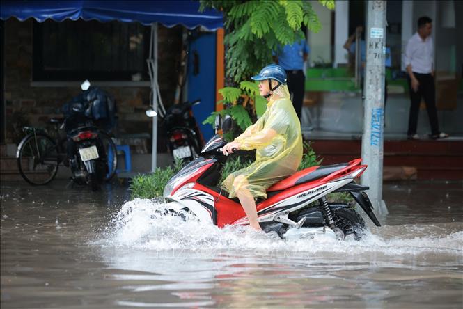
Specifically, in the Northwest and Viet Bac regions of the North, there will be moderate rain, heavy rain and thunderstorms with common rainfall of 30-60mm, locally very heavy rain over 120mm; other places in the North and Thanh Hoa will have scattered showers and thunderstorms, locally heavy rain with common rainfall of 10-30mm, locally over 60mm. Warning of the risk of heavy rain (over 100mm/3 hours). During thunderstorms, there is a possibility of tornadoes, lightning, hail and strong gusts of wind.
From the afternoon of October 8, heavy rain in the Northwest and Viet Bac regions of the North decreased.
Heavy rains can cause flooding in low-lying areas, urban and industrial areas; flash floods in small rivers and streams; landslides on steep slopes. Thunderstorms can cause tornadoes, lightning, hail and strong gusts of wind.
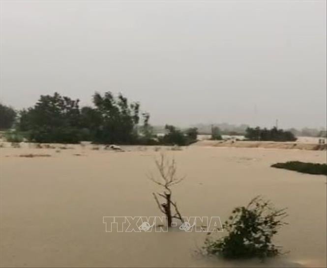
Floods on many rivers are rising rapidly.
Currently, floods on Cau River, Thuong River, Luc Nam River ( Bac Ninh ) are rising rapidly; water levels on other rivers in the North and Thanh Hoa are rising.
Water levels at 2:00 p.m. on October 7 on rivers are as follows: On Cau River at Gia Bay station 28.87m, 0.06m above the historical level in 2024 (28.81m), at Dap Cau station 5.24m, 0.06m below alarm level 2; on Thuong River at Cau Son station 16.4m, 0.4m above alarm level 3, at Phu Lang Thuong station 5.95m, 0.35m below alarm level 3; on Luc Nam River at Luc Nam station 5.29m, at alarm level 2; on Thai Binh River (Hai Phong) at Pha Lai station 4.1m (at 1:00 p.m. on October 7), 0.1m above alarm level 1.
It is forecasted that in the next 12 hours, the flood on Cau River at Dap Cau Station and Thuong River at Phu Lang Thuong Station will continue to rise above alert level 3; the flood on Luc Nam River at Luc Nam Station will continue to rise to alert level 2 - alert level 3. In the next 12 - 24 hours, the flood on Cau River at Dap Cau Station and Thuong River at Phu Lang Thuong Station will continue to rise and be above alert level 3, about 0.2 - 0.4m lower than the historical flood. The flood on Luc Nam River at Luc Nam Station is likely to change slowly at its peak between alert level 2 - alert level 3 on the night of October 7, then slowly decrease.
The National Center for Hydro-Meteorological Forecasting warns: From this afternoon (October 7) to October 9, floods on rivers in the Northern region and Thanh Hoa continue to rise. During this flood, the flood peak on the Thai Binh River ( Hai Phong ) will rise to alert level 2 - alert level 3; the flood peak on the Thao River (Lao Cai), Lo River (Tuyen Quang), Hoang Long River (Ninh Binh), and the upper Ma River (Thanh Hoa) will rise to alert level 1 - alert level 2, with some rivers above alert level 2.
Widespread flooding in Thai Nguyen, Bac Ninh, Lang Son, Cao Bang provinces and risk of flooding in low-lying areas along rivers, urban areas in the Northern region and Thanh Hoa; risk of landslides on river banks, river dykes, risk of flash floods on rivers and streams and landslides on steep slopes in mountainous areas of the Northern region and Thanh Hoa.
Floods on the river cause flooding in low-lying areas along the river, affecting activities such as waterway transport, aquaculture, agricultural production, people's lives and socio- economic activities. Flood disaster risk warning level: Level 3.
Thunderstorms and strong winds at sea
Currently, in the southern sea area of the Central East Sea, the Southern East Sea area (including Truong Sa special zone), the sea area from Khanh Hoa to Ca Mau, Ca Mau to An Giang, there are showers and thunderstorms.
Forecast for the night of October 7 and 8, in the southern sea area of the Central East Sea, the Southern East Sea area (including Truong Sa special zone), the sea area from Khanh Hoa to Ca Mau , Ca Mau to An Giang and the Gulf of Thailand, there will be scattered showers and thunderstorms. During the thunderstorms, there is a possibility of tornadoes, strong gusts of wind of level 6-7 and waves over 2m high. All vessels operating in the above areas are at risk of being affected by tornadoes and strong gusts of wind.
Specific weather in each region
The Northwest region has moderate rain, heavy rain and thunderstorms, some places have very heavy rain. During thunderstorms, beware of the possibility of tornadoes, lightning and strong gusts of wind. The lowest temperature is from 21-24 degrees Celsius, some places below 21 degrees Celsius; the highest temperature is from 27-30 degrees Celsius, some places above 30 degrees Celsius.
The Northeast region also has moderate to heavy rain and thunderstorms, with some places experiencing very heavy rain; the Northeast region, the plains and Thanh Hoa have scattered showers and thunderstorms at night and in the morning, with some places experiencing heavy rain. Southeast wind level 2-3. During thunderstorms, there is a possibility of tornadoes, lightning and strong gusts. The lowest temperature is 22-25 degrees Celsius, with some places experiencing below 22 degrees Celsius in mountainous areas; the highest temperature is 28-31 degrees Celsius, with some places experiencing above 31 degrees Celsius.
The area from Thanh Hoa to Hue will be sunny during the day, with showers and thunderstorms in some places in the late afternoon and at night. Southeast wind level 2-3. During thunderstorms, there is a possibility of tornadoes, lightning and strong gusts of wind. The lowest temperature is from 23-26 degrees Celsius; the highest is from 30-33 degrees Celsius, with some places above 33 degrees Celsius.
In the South Central Coast region, it is cloudy and sunny during the day; showers and thunderstorms in some places in the evening and at night. Southwest wind level 2-3. During thunderstorms, there is a possibility of tornadoes, lightning and strong gusts of wind. The lowest temperature is from 24-27 degrees Celsius; the highest is from 31-34 degrees Celsius.
During the day, the Central Highlands region has scattered showers and thunderstorms; in the late afternoon and evening, there are scattered showers and thunderstorms. Southwest wind level 2-3. During thunderstorms, be on guard for the possibility of tornadoes, lightning, and strong gusts of wind. The lowest temperature is from 18-21 degrees Celsius; the highest is from 28-31 degrees Celsius, with some places above 31 degrees Celsius.
In the South, there will be scattered showers and thunderstorms during the day; in the late afternoon and evening, there will be scattered showers and thunderstorms. Southwest wind force 2-3. During thunderstorms, there is a possibility of tornadoes, lightning, and strong gusts of wind. Lowest temperature from 23-26 degrees Celsius; highest temperature from 31-34 degrees Celsius.
Hanoi capital will have scattered showers and thunderstorms at night and in the morning, with some places having heavy rain. Southeast wind level 2-3. During thunderstorms, there is a possibility of tornadoes, lightning and strong gusts of wind. Lowest temperature from 23-25 degrees Celsius; highest from 29-31 degrees Celsius.
In Ho Chi Minh City, the weather is cloudy with scattered showers and thunderstorms in some places; in the late afternoon and evening, there will be scattered showers and thunderstorms in some places. Southwest wind level 2-3. Warning of tornadoes, lightning and strong gusts of wind in thunderstorms. Lowest temperature from 23-25 degrees Celsius; highest from 31-33 degrees Celsius.
Source: https://baotintuc.vn/van-de-quan-tam/lu-tren-cac-song-bac-bo-va-thanh-hoa-tiep-tuc-len-do-van-con-mua-20251007171816409.htm


![[Photo] Prime Minister Pham Minh Chinh chairs the 16th meeting of the National Steering Committee on combating illegal fishing.](https://vphoto.vietnam.vn/thumb/1200x675/vietnam/resource/IMAGE/2025/10/07/1759848378556_dsc-9253-jpg.webp)


![[Photo] Super harvest moon shines brightly on Mid-Autumn Festival night around the world](https://vphoto.vietnam.vn/thumb/1200x675/vietnam/resource/IMAGE/2025/10/07/1759816565798_1759814567021-jpg.webp)


Comment (0)