

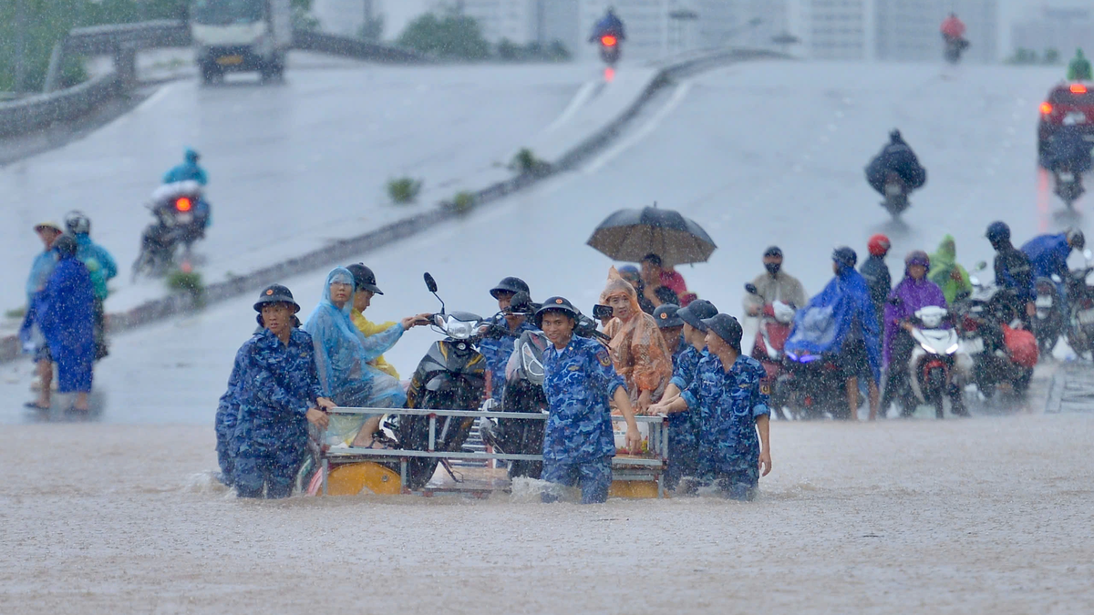
Heavy rain over a large area caused many streets in Hanoi to be submerged in water.
Since the end of September, the North has been experiencing two consecutive large-scale heavy rains due to the influence of storm circulation. Particularly in Thai Nguyen and Hanoi, the measured rainfall has exceeded 500 mm in some places, causing localized flooding and potential risks of floods and landslides.
According to the National Center for Hydro-Meteorological Forecasting, the heavy rain on October 7 has many similarities with the rain that occurred on September 29-30. Both periods are due to the impact of meridional wind convergence (winds from many Southeast and Southwest directions converging along longitude) combined with post-storm circulation and the humid Southeast wind zone of the subtropical high pressure, causing the rain to concentrate mainly in the Northern region, focusing on the capital Hanoi.
However, the rain on September 30 lasted longer and caused more widespread flooding than the rain on the morning of October 7. The highest hourly rainfall intensity of the two periods was 101.4 mm (at Dinh Cong, September 30) and 108.2 mm (at Me Tri, October 7), respectively.
In terms of distribution, on September 30, heavy rain was concentrated in the inner city and northern areas of Hanoi, with rainfall ranging from 200 mm/24 hours to 300 mm/24 hours; the western and southwestern areas (Ba Vi, Xuan Mai, Chuong My, Son Tay) had lighter rain, around 60 mm-90 mm. Meanwhile, the rain on October 7 was mainly concentrated in the inner city, including Me Tri, Lang, Cau Dien, Ha Dong, Phu Lam, Dong Anh, with fewer spots with rainfall over 100 mm.
From the morning of October 6 to the morning of October 7, under the influence of storm circulation No. 11 and the convergence of meridional winds, the Northern region experienced moderate to heavy rain over a wide area. In particular, Thai Nguyen and Hanoi were the two localities that recorded exceptionally heavy rainfall.
In Thai Nguyen, the rainfall from 7 p.m. on October 6 to 9 a.m. on October 7 reached a record level: Hoa Thuong station 526 mm, Cay Thi station 462 mm. Many other localities also had heavy rainfall such as Bo Ha station ( Bac Ninh ) 348 mm, Me Tri station (Hanoi) 261.6 mm, Soc Son station (Hanoi) 242.4 mm, Tan Tri 1 station (Lang Son) 224.4 mm, Chuc Bai Son station (Quang Ninh) 216 mm.
Flood warning and widespread flooding
According to meteorological experts, the circulation of the weakened low pressure area from storm No. 11 moving into the northwest region, combined with the strong southeast wind zone of the subtropical high pressure encroaching from the east, created a wind convergence zone along the Tuyen Quang-Thai Nguyen-Hanoi-Lang Son strip, causing continuous heavy rain for many hours.
Hydrometeorological experts also forecast that in the afternoon and evening of October 7, the convergence of the meridional winds will weaken, but the North will still have moderate to heavy rain, with a common amount of 30-60 mm, locally over 100 mm in Tuyen Quang, Thai Nguyen and Hanoi. By night, the rain will decrease, but in the early morning of October 8, the Northeast region may rain again.
Due to the impact of heavy rain from today (October 7) to October 10, floods on rivers in the Northern region and Thanh Hoa continue to rise. During this flood, the flood peak on rivers in Cao Bang, Lang Son, Quang Ninh provinces, Luc Nam River (Bac Ninh), Thai Binh River (Hai Phong) will rise to level BĐ2-BĐ3 and above BĐ3; the flood peak on Thao River (Lao Cai), Lo River (Tuyen Quang), Hoang Long River (Ninh Binh), and the upper Ma River (Thanh Hoa) will rise to level BĐ1-BĐ2, with some rivers above BĐ2; the flood peak reaching Hoa Binh Lake and the lower Red River at Hanoi station is likely to be above BĐ1.
Widespread flooding in Thai Nguyen, Bac Ninh, Lang Son, Cao Bang provinces and risk of flooding in low-lying areas along rivers, urban areas in the Northern region and Thanh Hoa; risk of landslides on river banks, river dykes, risk of flash floods on rivers and streams and landslides on steep slopes in mountainous areas of the Northern region and Thanh Hoa.
Thu Cuc
Source: https://baochinhphu.vn/ly-giai-nguyen-nhan-hai-dot-mua-lon-dien-rong-tai-mien-bac-10225100716151731.htm


![[Photo] Prime Minister Pham Minh Chinh chairs the 16th meeting of the National Steering Committee on combating illegal fishing.](https://vphoto.vietnam.vn/thumb/1200x675/vietnam/resource/IMAGE/2025/10/07/1759848378556_dsc-9253-jpg.webp)


![[Photo] Super harvest moon shines brightly on Mid-Autumn Festival night around the world](https://vphoto.vietnam.vn/thumb/1200x675/vietnam/resource/IMAGE/2025/10/07/1759816565798_1759814567021-jpg.webp)


Comment (0)