
Experts explain the sudden change in weather in northern Vietnam these days, with temperatures soaring above 40°C before suddenly dropping sharply.
However, just a week later, on June 1st and 2nd, temperatures soared, and the North entered a severe heatwave, with temperatures exceeding 40°C in some areas, leaving the road surface scorching hot.
According to Mr. Nguyen Hong Sinh, Deputy Director of the Hai Phong City Meteorological and Hydrological Station, the cause of this sudden heatwave is the strong development of a hot low-pressure area in the West, combined with the Foehn effect, causing widespread heatwaves in the Northern and Central regions, with some areas experiencing particularly intense heat.
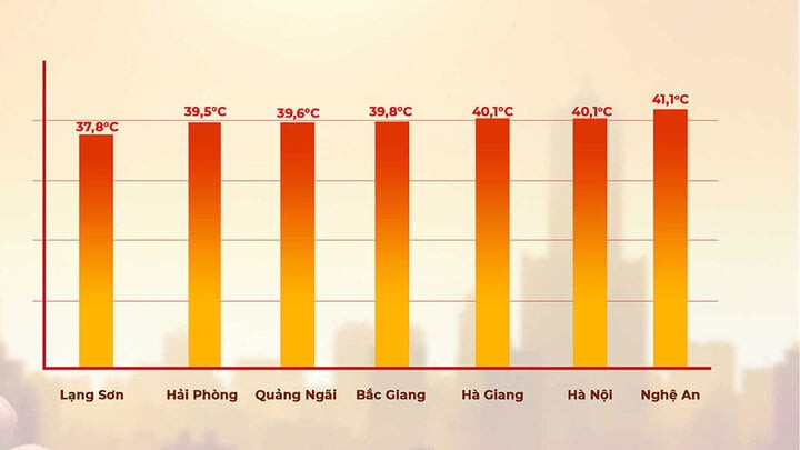
On June 2nd, many meteorological stations across the country recorded high temperatures. Specifically, Tuong Duong (Nghe An) recorded 41.1°C; Lang station ( Hanoi ) 40.6°C; and Phu Lien station (Hai Phong) 39.5°C.
In addition, other places also recorded high temperatures such as Bac Me ( Ha Giang ) with a recorded temperature of 40.1°C; Dinh Lap (Lang Son) 37.8°C; Son Dong (Bac Giang) 39.8°C; and Quang Ngai 39.6°C.
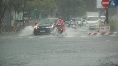
After two days of scorching heat, temperatures in the North suddenly dropped by nearly 10°C following widespread thunderstorms, temporarily ending the heatwave. Today, the highest temperature in Hanoi is forecast to be around 32-34°C, while other areas will generally be 31-34°C, with some places exceeding 34°C, and some mountainous areas reaching 30°C.
"Today (June 3rd), the trough connected to the hot low-pressure area in the West is being compressed and pushed southward by the continental cold air mass in the North. Currently, the trough connected to the hot low-pressure area in the West has crossed the Northern region and its axis runs through the North Central region."
Thus, with this weather pattern, the heatwave in Northern Vietnam has ended. However, the heatwave will continue in Nghe An and Ha Tinh today." Mr. Sinh commented.

According to the National Center for Hydro-Meteorological Forecasting, on the afternoon and night of June 3rd, the Northern and North Central regions will experience scattered showers and thunderstorms, with localized heavy rain, with rainfall amounts of 15-30mm, and in some places over 80mm. On the day and night of June 3rd, the Southern region will experience showers and thunderstorms, with some areas experiencing heavy rain, with rainfall amounts of 20-40mm, and in some places over 80mm.
The ENSO phenomenon is expected to remain neutral until the end of November with a probability of 55–90%. From June to November 2025, typhoons and tropical depressions will be active in the South China Sea and affect the mainland at approximately the multi-year average (the multi-year average in the South China Sea is 11 storms, with 4.9 landfalls). National rainfall during this period will remain approximately the same as the multi-year average.
On the morning of May 29th, at a meeting with relevant units regarding the upcoming rainfall and flood situation, Mr. Mai Van Khiem, Director of the National Center for Meteorological and Hydrological Forecasting, stated that moderate to heavy rain is predicted to occur mainly from June to August in the Northern, North Central, Central Highlands, and Southern regions. In particular, the Central region will experience increased rainfall from September to December. The heatwave will gradually decrease in the Central Highlands and Southern regions, while it will persist in the Northern and Central regions until August 2025.
Source: https://baolangson.vn/mien-bac-dang-nang-bong-rat-40-c-lai-mat-me-la-thuong-chuyen-gia-ly-giai-5049061.html


![[Photo] Closing Ceremony of the 10th Session of the 15th National Assembly](/_next/image?url=https%3A%2F%2Fvphoto.vietnam.vn%2Fthumb%2F1200x675%2Fvietnam%2Fresource%2FIMAGE%2F2025%2F12%2F11%2F1765448959967_image-1437-jpg.webp&w=3840&q=75)


![[OFFICIAL] MISA GROUP ANNOUNCES ITS PIONEERING BRAND POSITIONING IN BUILDING AGENTIC AI FOR BUSINESSES, HOUSEHOLDS, AND THE GOVERNMENT](https://vphoto.vietnam.vn/thumb/402x226/vietnam/resource/IMAGE/2025/12/11/1765444754256_agentic-ai_postfb-scaled.png)


Comment (0)