

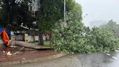
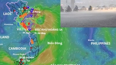
From about 13 to 14 o'clock this afternoon, August 24, many places in the Northern Delta such as Hanoi , Bac Ninh, Hai Phong and Hung Yen experienced dense thunderstorms.

According to meteorological experts, these cloud bands are caused by the western trough of storm No. 5 (Kajiki), signaling that heavy rain will increase in the North from this afternoon.
In Bac Giang ward, people said that dark clouds appeared since noon today. In Hanoi, many people were watching the parade rehearsal while many areas had heavy rain.
")
At 1 p.m., the National Center for Hydro-Meteorological Forecasting issued a third warning about a strong thunderstorm moving from the East (Hung Yen and Hai Phong) to the center of Hanoi, recommending that people limit outdoor travel during this dangerous time.
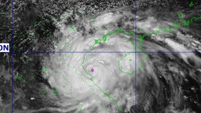
Meteorological experts warn that this afternoon, the eye of storm No. 5 has formed with a cloud cover covering most of the northern and central areas of the East Sea. Currently, storm No. 5 has reached hurricane level with winds of 119 - 153 km/h, and may become stronger as it approaches the shore due to favorable atmospheric conditions.

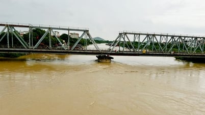
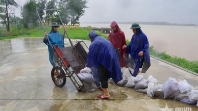
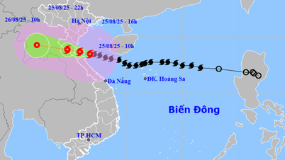
Many experts warn that the danger level of this storm could be equal to, or even exceed, that of Typhoon Yagi (in September 2024). Nghe An, Ha Tinh, Thanh Hoa and Quang Binh are warned to be particularly dangerous as strong winds and heavy rains will begin this evening, causing the risk of flooding, landslides and widespread traffic disruption.
Coastal provinces from Quang Tri to Thanh Hoa need to evacuate people from dangerous areas and reinforce infrastructure, while inner-city residents need to closely follow instructions from authorities.
Meteorological experts warn that the devastating scenario of storm No. 5 in the North Central region is similar to that of storm Yagi, which devastated Hai Phong - Quang Ninh in September 2025, and will be even more severe if the infrastructure cannot withstand it, or if prevention work is not seriously prepared.

Updated at 2:00 p.m. on August 24 from the National Center for Hydro-Meteorological Forecasting, storm No. 5 was at coordinates of approximately 17.4 degrees North latitude - 110.3 degrees East longitude, in the sea northwest of Hoang Sa special zone; 520km from Nghe An, 500km from Ha Tinh, 430km from North of Quang Tri. Wind force is still level 13, gusting to level 15; moving west at 20km/hour, still likely to strengthen.
Source: https://www.sggp.org.vn/mien-bac-truoc-bao-so-5-nhieu-noi-keo-may-den-troi-toi-mit-post809938.html


![[Photo] General Secretary To Lam attends the 80th anniversary of Vietnam's diplomacy](https://vphoto.vietnam.vn/thumb/1200x675/vietnam/resource/IMAGE/2025/8/25/3dc715efdbf74937b6fe8072bac5cb30)


![[E-Magazine] Petrovietnam – Strong steps to realize the “Epochal Transformation”](https://vphoto.vietnam.vn/thumb/402x226/vietnam/resource/IMAGE/2025/8/25/e745baade70f4e1e96f5314f65eac658)


Comment (0)