

Heavy rain from tonight and tonight until the morning of July 23, focusing on Hung Yen , Ninh Binh, Nam Phu Tho, Thanh Hoa, Nghe An - Illustrative photo
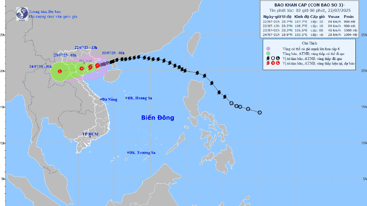
At 5:00 p.m. this afternoon (July 21), the center of the storm was at about 20.9 degrees North latitude; 108.7 degrees East longitude, about 100km from Quang Ninh, 220km from Hai Phong ; about 240km from Hung Yen, about 270km from Ninh Binh.
The strongest wind near the storm center is level 10 (75-102km/h), gusting to level 12; moving in the West Southwest direction at a speed of about 15km/h.
Observations up to now: In Quang Ninh : Uong Bi, Mong Cai wind gusts level 7; Bai Chay wind gusts level 6; Co To strong wind level 6, gusts level 7;…
In Hai Phong: Bach Long Vy Special Zone has strong wind of 18 m/s (level 8), gusts of 25 m/s (level 10); highest wave is 1.7 m; Hon Dau has strong wind of 6 m/s (level 4), gusts of 8 m/s (level 5); Phu Lien has strong wind of 8 m/s (level 5), gusts of 16 m/s (level 7)
From yesterday (July 20) to this evening (July 21), in the Northeast region, the Northern Delta, Thanh Hoa and Nghe An, there has been moderate rain, some places have had heavy to very heavy rain such as: Long Dinh station (Quang Ninh) 131.4mm, Cam Pha station (Quang Ninh) 130.8mm, Thanh Mai station (Nghe An) 104.4mm, Cat Ba station (Hai Phong) 89.4mm, Quang Chieu station (Thanh Hoa) 73.6mm.
Due to the impact of storm No. 3, in Bach Long Vi special zone, there were strong winds of level 8, gusting to level 9; in Co To and Cat Ba special zones (Cat Hai special zone), there were strong winds of level 6, gusting to level 7.
Note the impacts of storm number 3
The National Center for Hydro-Meteorological Forecasting notes the impacts of the storm.
Wind impact: The northern Gulf of Tonkin (including the special zones of Bach Long Vi, Co To, Van Don, Cat Hai, Hon Dau island) has strong winds of level 6-7, then increasing to level 8-9, the area near the storm's eye has level 10-11, gusts of level 14, waves 2.0-4.0m high, the area near the storm's eye has 4.0-6.0m, the sea is very rough. The southern Gulf of Tonkin (including Hon Ngu island) has winds gradually increasing to level 6-7, the area near the storm's eye has level 8-9, gusts of level 11, waves 2.0-4.0m high, the sea is very rough.
From noon to tomorrow afternoon (July 22), the storm center will make landfall in the provinces from Hai Phong to North Thanh Hoa; coastal areas of Hai Phong and Hung Yen: Wind level 9-10, gusting to level 13-14; coastal areas of Ninh Binh: Wind level 8-9, gusting to level 13; coastal areas of Thanh Hoa (concentrated in the North): Wind level 7-8, gusting to level 8-9; Hanoi: Strong wind level 5-6, gusting to level 7-8 tomorrow afternoon.
High tides (including storm surges) are forecast to occur in the afternoon of July 22, specifically: At Ba Lat (Hung Yen) 2.4-2.6m high (13-16 hours); at Hon Dau (Hai Phong) 3.9-4.3m high (13-16 hours); at Cua Ong (Quang Ninh) 4.6-5.0m high (14-17 hours); and at Tra Co (Quang Ninh) 3.6-4.0m high (14-17 hours).
Impact on rain: Heavy rain over a wide area from tonight and tonight until the morning of July 23, focusing on Hung Yen, Ninh Binh, South Phu Tho, Thanh Hoa, Nghe An, generally 200-350mm, locally over 600mm; other places in the Northern region and Ha Tinh have moderate rain, heavy rain, locally very heavy rain and thunderstorms with common rainfall of 100-200mm, locally over 300mm. Warning of the risk of heavy rain (>150mm/3h). Heavy rain in a short period of time can cause flash floods, landslides in mountainous areas, flooding in low-lying areas.
Flood impact: From tonight (July 21) to July 25, 2025, there will be a flood on rivers in the North, Thanh Hoa, and Nghe An, with a flood amplitude of 3-6m on rivers. During this flood, the flood peak on small rivers, the upper Ma River is likely to reach level 2-3; the flood peak on Thao River, Lo River, Da River at Hoa Binh Lake, Thai Binh River, Hoang Long River, the upper Ca River will reach level 1-2, some rivers above level 2; the flood peak downstream of the Red River will be below level 1; the lower Ma River and Ca River will fluctuate at level 1. There is a high risk of flooding in low-lying areas along rivers, urban areas in the Northern Delta, Thanh Hoa, and Nghe An; flash floods and landslides on steep slopes in the area.
Some key areas to note
On coping with strong coastal winds, waves and surges:
Quang Ninh: Wards: Bai Chay, Ha Tu. Hong Gai, Ha Long, Mong Cai 1,2,3; Co To and Van Don Special Zones
Hai Phong: Bach Long Vy Special Zone; Cat Hai Special Zone, Wards: Hai An, Duong Kinh, Do Son and communes: Kien Thuy, Tien Lang
Ninh Binh: 15 coastal communes including Giao Minh Commune, Giao Hoa Commune, Giao Phuc Commune, Giao Hung Commune, Giao Binh Commune, Giao Ninh Commune, Hai Hung Commune, Hai Quang Commune, Hai Tien Commune, Hai Xuan Commune, Hai Thinh Commune, Rang Dong Commune, Nghia Lam Commune, Kim Dong Commune, Binh Minh Commune; Con Tron dyke section from K20+000 - K21+633; Hai Hau sea dyke; Con Tron dyke, Hai Thinh II, Hai Thinh III
Hung Yen: Thai Thuy commune and Tien Hai commune.
Thanh Hoa: 16 communes in the waterfront area include Nga An, Tan Tien, Van Loc, Hoa Loc, Hoang Tien, Hoang Thanh, Sam Son, Nam Sam Son, Quang Ninh, Quang Binh, Tien Trang, Ngoc Son, Tan Dan, Hai Linh, Tinh Gia, Hai Binh and Nghi Son communes.
Regarding the risk of flash floods and landslides: Thanh Hoa (24 communes): Muong Lat, Muong Chanh, Muong Ly, Nhi Son, Pu Nhi, Quang Chieu, Tam Chung, Trung Ly, Quan Son, Tam Lu, Trung Ha, Na Meo, Son Thuy, Son Dien, Muong Min, Tam Thanh, Hoi Xuan, Nam Xuan, Thien Phu, Hien Kiet, Phu Le, Trung Thanh, Trung Son, Phu Xuan...
Nghe An (50 communes): Bac Ly, Chieu Luu, Huoi Tu, Huu Kiem, Keng Du, Muong Xen, Muong Long, Muong Tip, My Ly, Na Loi, Na Ngoi, Nam Can, Huu Khuong, Luong Minh, Nga My, Nhon Mai, Tam Quang, Tam Thai, Tuong Duong, Yen Hoa, Yen Na, Muong Quang, Que Phong, Thong Thu, Tien Phong, Tri Le, Binh Chuan, Cam Phuc, Chau Khe, Con Cuong, Mau Thach, Mon Son, Chau Binh, Chau Tien, Hanh Thiet, Hung Chan, Quy Chau, Chau Hong, Chau Loc, Minh Hop, Muong Chong, Muong Ham, Quy Hop, Tam Hop, Nghia Dan, Nghia Hung, Nghia Khanh, Nghia Lam, Nghia Loc, Nghia Mai, Nghia Tho
Son La: Muong Leo, Moc Chau Ward, Pung Banh
The Center for Hydro-Meteorological Forecasting recommends that people regularly monitor storm forecast and warning information from official channels such as the National Center for Hydro-Meteorological Forecasting, local television and radio stations, weather applications or ward/commune loudspeakers.
Reinforce the house, brace the roof and windows, trim tree branches near the house, and collect objects that can be blown away by the wind.
Stock up on necessities, medicine, flashlights, power banks... in case of power outage or evacuation.
Do not leave the house when there is strong wind, heavy rain, thunder, stay away from areas at risk of landslides, flash floods, deep floods, ponds, lakes, and construction sites.
Move safely, do not go through flooded areas or areas with electric shock when storms occur.
Strictly comply with evacuation and relocation instructions of local authorities.
Thu Cuc
Source: https://baochinhphu.vn/mot-so-khu-vuc-trong-tam-bi-anh-huong-bao-so-3-canh-bao-nguy-co-mua-cuong-suat-lon-102250721190010775.htm


![[Photo] National Assembly Chairman Tran Thanh Man visits Vietnamese Heroic Mother Ta Thi Tran](https://vphoto.vietnam.vn/thumb/1200x675/vietnam/resource/IMAGE/2025/7/20/765c0bd057dd44ad83ab89fe0255b783)


Comment (0)