

Very heavy rain in many areas, locally over 150mm
The National Center for Hydro-Meteorological Forecasting said that from the night of October 5 to the night of October 6, in the mountainous and midland areas of the North, there will be heavy rain, locally very heavy rain with common rainfall of 100-180mm, locally over 300mm. The Northern Delta and Thanh Hoa areas will have moderate rain, heavy rain, locally very heavy rain with common rainfall of 50-100mm, locally over 150mm. Warning of the risk of heavy rain (>150mm/3h).
In addition, in the afternoon and evening of October 5, in the Northeast region, there will be scattered showers and thunderstorms, locally heavy rain with rainfall of 10-30mm, locally over 50mm, with the possibility of tornadoes, lightning, hail and strong gusts of wind.
Warning, during the day and night of October 7, in the mountainous and midland areas of the North, there will be moderate rain, heavy rain, locally very heavy rain with common rainfall of 30-70mm, locally over 150mm. The Northern Delta and Thanh Hoa areas will have moderate rain, locally heavy rain with common rainfall of 20-50mm, locally over 80mm (Total rainfall from the night of October 5 to the end of the night of October 7, in the mountainous and midland areas of the North, it will be generally from 150-250mm, locally over 400mm; the Northern Delta and Thanh Hoa areas will be generally 70-150mm, locally over 200mm).
Level 1 natural disaster risk due to heavy rain, tornado, lightning, hail.
On the night of October 4 and the morning of October 5, in the area from Da Nang city to Lam Dong and the South, there will be scattered showers and thunderstorms, with some places having heavy to very heavy rain. The rainfall from 7:00 p.m. on October 4 to 8:00 a.m. on October 5 was over 90mm in some places, such as: Dak Pek station (Quang Ngai) 90.2mm, Cat Tien station (Gia Lai) 129.6mm,...
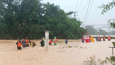
Flood warning on rivers in the Northern region, Thanh Hoa and the Mekong River
The National Center for Hydro-Meteorological Forecasting forecasts that on rivers in the Northern region, Thanh Hoa is likely to see a flood, with the flood amplitude rising from 4-8m in the upper reaches of rivers, from 2-5m in the lower reaches of rivers. During this flood, the flood peak on rivers in Quang Ninh, Lang Son, Cao Bang provinces; the flood peak on Thao River, Chay River (Lao Cai), Hoang Long River (Ninh Binh), Lo River (Tuyen Quang), Thai Binh River system (Thai Nguyen, Bac Ninh, Hai Phong) and small rivers will reach alert level 2 - alert level 3 and above alert level 3; the flood peak at Hoa Binh Lake, Buoi River, Ma River, Chu River (Thanh Hoa), the lower reaches of the Red River will reach alert level 1 - alert level 2, in some places above alert level 2.
Flood risk warning level 2.
On the Mekong River, due to the influence of upstream floods combined with high tides, the headwaters of the Mekong River continue to rise and peak from October 8-10, after changing slowly. The flood peak on the Tien River at Tan Chau station is likely to reach 3.85m, 0.15m below alert level 2; on the Hau River at Chau Doc station is likely to reach 3.4m, 0.1m below alert level 2; at downstream stations of the Mekong River, it will reach alert level 2 - alert level 3, in some places 0.1 - 0.3m above alert level 3.
There is a high risk of flooding in low-lying areas, riverside areas, and areas outside the dykes in An Giang province and low-lying areas, riverside areas in Dong Thap, Can Tho, and Vinh Long provinces. Be careful of landslides and weak dykes in flooded areas.
Flood disaster risk warning level 1.
Many sea areas have strong winds and high waves.
According to information from the National Center for Hydro-Meteorological Forecasting, at sea, on the night of October 5, in the Southern Gulf of Tonkin, the wind will gradually increase to level 6, sometimes level 7, gusting to level 8-9, rough seas, waves 2-3m high.
In addition, on the day and night of October 5, the northwest sea area of the North East Sea will have storms; in the Gulf of Tonkin, the central East Sea area, the sea area from South Quang Tri to Hue city and from Ca Mau to An Giang and the Gulf of Thailand, there will be scattered showers and thunderstorms; in the northern Gulf of Tonkin, from the afternoon of October 5, there will be storms, with the possibility of tornadoes, strong gusts of wind of level 6-7 and waves over 2m high.
Warning: On October 6, the Northern Gulf of Tonkin area (including Bach Long Vy, Van Don, Co To, Cat Hai and Hon Dau islands) will have strong winds of level 6-7, near the storm center level 8-9, gusting to level 12; waves 2-3m high; near the storm center 3-4m high; very rough seas.
Disaster risk level in the southern Gulf of Tonkin is level 2.
All vessels operating in the above areas are at high risk of being affected by strong winds and large waves.
Source: https://www.sggp.org.vn/nguy-co-mua-lon-trong-3-gio-o-bac-bo-va-thanh-hoa-tu-dem-nay-5-10-post816460.html
![[Photo] Visit Hung Yen to admire the "wooden masterpiece" pagoda in the heart of the Northern Delta](/_next/image?url=https%3A%2F%2Fvphoto.vietnam.vn%2Fthumb%2F1200x675%2Fvietnam%2Fresource%2FIMAGE%2F2025%2F11%2F21%2F1763716446000_a1-bnd-8471-1769-jpg.webp&w=3840&q=75)
![[Photo] General Secretary To Lam receives President of the Senate of the Czech Republic Milos Vystrcil](/_next/image?url=https%3A%2F%2Fvphoto.vietnam.vn%2Fthumb%2F1200x675%2Fvietnam%2Fresource%2FIMAGE%2F2025%2F11%2F21%2F1763723946294_ndo_br_1-8401-jpg.webp&w=3840&q=75)
![[Photo] President Luong Cuong receives Speaker of the Korean National Assembly Woo Won Shik](/_next/image?url=https%3A%2F%2Fvphoto.vietnam.vn%2Fthumb%2F1200x675%2Fvietnam%2Fresource%2FIMAGE%2F2025%2F11%2F21%2F1763720046458_ndo_br_1-jpg.webp&w=3840&q=75)


![[Photo] National Assembly Chairman Tran Thanh Man holds talks with President of the Senate of the Czech Republic Milos Vystrcil](/_next/image?url=https%3A%2F%2Fvphoto.vietnam.vn%2Fthumb%2F1200x675%2Fvietnam%2Fresource%2FIMAGE%2F2025%2F11%2F21%2F1763715853195_ndo_br_bnd-6440-jpg.webp&w=3840&q=75)


Comment (0)