
Some bridges on the Da River and the Red River are dry ( Video : Huu Nghi).

Van Lang Bridge across the Red River is the border point between Phu Cuong commune (Ba Vi, Hanoi ) and Tho Son ward (Viet Tri city, Phu Tho), located in the area of the confluence of the Red River - Da River - Lo River with complex flows, especially many sand mines.
Photo of Van Lang bridge taken on January 14.

Due to the low water level of the Red River, the pile foundation of Van Lang Bridge is exposed above the water surface by 50cm. This phenomenon may have occurred because the riverbed has sunk due to sand mining, and the upstream water is slow to return.

The Red River bed at Van Lang Bridge is about 1.5km wide on average, but when the water is low, the alluvial plains encroach and narrow most of the flow.
Photo of a large riverside alluvial plain in Phu Cuong commune (Ba Vi, Hanoi).

Although the bridge is still safe, this phenomenon raises many concerns about the flow of the Red River in an area where many sand mines are continuously exploited.

Belonging to a large area at the intersection of three rivers, the flow is complex, alluvial plains appear frequently, the riverbed is often narrowed by more than half.

It is estimated that at present there are about 7 Van Lang bridge pillars with exposed foundations.

The Da River is also in the dry season, and sandbanks are gradually forming.
The photo of Trung Ha bridge across Da river has a similar design to Van Lang bridge, 8.2km apart as the crow flies.

Image of the foundation of Trung Ha bridge piers.

Currently, the water level of the Da River is low but not at its lowest. In 2023, due to water shortage, the Da River Clean Water Investment Joint Stock Company (Viwasupco) is having to take water through an emergency pumping station located in the middle of the river to supply more than one million people in Hanoi.

New alluvial land appeared at Trung Ha bridge.

Dong Quang Bridge is located more than 17km upstream from Trung Ha Bridge, crossing the Da River, and is also the border point between Hanoi and Phu Tho province on provincial road 87A.

The low water level of the Da River has begun to expose the foundations of the Dong Quang bridge piers.

The water level of the Da River is often regulated by hydroelectric reservoirs. When the reservoirs are full, they will dry up downstream and vice versa.

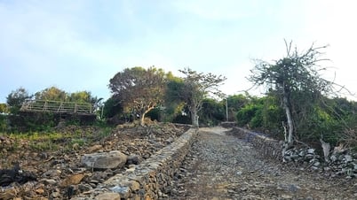
The embankment project to prevent landslides on the Da River bank in the K9 area has just been completed.
Source: https://dantri.com.vn/xa-hoi/nhung-cay-cau-tro-mong-giua-long-song-da-song-hong-can-nuoc-20250115081156277.htm


![[Photo] Central Propaganda and Mass Mobilization Department meets with exemplary journalists](https://vphoto.vietnam.vn/thumb/1200x675/vietnam/resource/IMAGE/2025/6/21/9509840458074c03a5831541450d39f8)


![[Maritime News] Wan Hai Lines invests $150 million to buy 48,000 containers](https://vphoto.vietnam.vn/thumb/402x226/vietnam/resource/IMAGE/2025/6/20/c945a62aff624b4bb5c25e67e9bcc1cb)


Comment (0)