
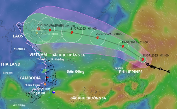
Dangerous areas at sea (strong winds from level 6 or higher) are from latitude 16.5 to 21 degrees north, from longitude 117.5 to 120 degrees east.
Areas with scattered showers and thunderstorms, possibility of tornadoes and strong gusts of wind, include: southeast of the North East Sea; central and southern East Sea (including Truong Sa special zone); sea areas from Lam Dong to Ca Mau, Ca Mau to An Giang and the Gulf of Thailand.
To proactively respond to the development of the tropical depression that is likely to strengthen into a storm, the Steering Committee for Natural Disaster Prevention, Search and Rescue and Civil Defense of Da Nang City has issued a document and requested the Command of the City Border Guard, the Da Nang Coastal Information Station and coastal localities and related units to promptly notify owners of vehicles and boats still operating at sea of information about the tropical depression near the East Sea so that they can proactively avoid it.
The City Border Guard Command proactively manages ships going out to sea.
Departments, branches, localities and units closely monitor the developments of the tropical depression to proactively handle possible situations...
Source: https://baodanang.vn/theo-doi-dien-bien-cua-ap-thap-nhet-doi-gan-bien-dong-de-chu-dong-ung-pho-3297140.html


![[Infographic] In 2025, 47 products will achieve national OCOP](https://vphoto.vietnam.vn/thumb/402x226/vietnam/resource/IMAGE/2025/7/16/5d672398b0744db3ab920e05db8e5b7d)


Comment (0)