

Boats anchored to avoid storm number 3. Weather forecast for the North today is very bad (Photo: TL)
The National Center for Hydro-Meteorological Forecasting said that today, July 22, due to the influence of storm No. 3, the weather in many places is very bad.
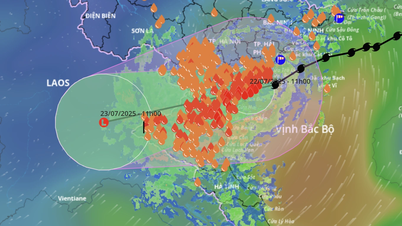
Specifically, from yesterday evening, today until tomorrow, July 23, the Northeast region, the Northern Delta, Thanh Hoa and Nghe An will have heavy to very heavy rain and thunderstorms. Rainfall is generally 200 - 350mm, in some places over 600mm.
Other places in the North and Ha Tinh have moderate rain, heavy rain, some places have very heavy rain and thunderstorms. Rainfall is generally 100 - 200mm, some places over 300mm.
Warning of risk of heavy rain (>150mm/3h). Thunderstorms may have tornadoes, lightning, hail and strong gusts of wind.
From Quang Tri to Da Nang , the Central Highlands and the South, there will be scattered showers and thunderstorms, with heavy rain in some places. Rainfall is 10 - 30mm, with over 70mm in some places (rain is concentrated in the late afternoon).
Regarding storm number 3 Wipha, it is forecasted that the storm will make landfall in our country today. Previously, the storm caused the northwest sea area of the northern East Sea to have strong winds of level 7-8, gusts of level 10, waves 3-5m high, and rough seas.
The northern sea area of Bac Bo Gulf (including the special zones of Bach Long Vi, Co To, Van Don, Cat Hai, Hon Dau island) has strong winds of level 6-7, then increasing to level 8-9, the area near the storm's eye has level 10-11, gusting to level 14, waves 2-4m high, the area near the storm's eye has 4-6m high, the sea is very rough.
The southern Gulf of Tonkin (including Hon Ngu Island) has winds gradually increasing to level 6-7, near the storm center level 8-9, gusting to level 11, waves 2-4m high, very rough seas.
The coastal areas from Hung Yen to Quang Ninh have storm surges of 0.5 - 1m high. Water levels at Ba Lat (Hung Yen) are 2.4 - 2.6m high, Hon Dau (Hai Phong) are 3.9 - 4.3m high, at Cua Ong (Quang Ninh) are 4.6 - 5m high and at Tra Co (Quang Ninh) are 3.6 - 4m high.
High risk of flooding in coastal areas and river mouths this afternoon.
In addition, the weather at sea and coastal areas during storms is extremely dangerous and unsafe for any ships to operate.
Detailed weather forecast today July 22:
Hanoi is cloudy, heavy to very heavy rain. Strong wind level 5-6, gust level 7-8. Lowest temperature 23-25 degrees Celsius, highest 27-29 degrees Celsius.
Northwest cloudy, moderate rain, heavy rain and thunderstorms, some places have very heavy rain. Lowest temperature 22-26 degrees Celsius, highest 27-30 degrees Celsius.
The Northeast region is cloudy with moderate to heavy rain, especially in the Northeast and the plains. In the provinces/cities of Hai Phong, Hung Yen, Ninh Binh, the wind is strong at level 6, gusting at level 7-8, especially in the coastal areas from Quang Ninh to Ninh Binh, the wind is strong at level 7-9, near the storm center at level 10-11, gusting at level 14. The lowest temperature is 22-26 degrees Celsius, the highest is 27-30 degrees Celsius.
Thanh Hoa to Hue is cloudy, the north has moderate rain, heavy rain and thunderstorms, especially Thanh Hoa to Nghe An has very heavy rain; the south has scattered showers and thunderstorms. Coastal areas from Thanh Hoa to Nghe An have strong winds of level 7-9, near the storm center have levels 10-11, gusts of level 14. Inland areas of Thanh Hoa have strong winds of level 6, gusts of level 7-8. Lowest temperature 24-27 degrees Celsius, highest 27-31 degrees Celsius.
South Central Coast cloudy, scattered showers and thunderstorms. Lowest temperature 26-29 degrees Celsius, highest 31-34 degrees Celsius.
Central Highlands cloudy, showers and thunderstorms, heavy rain in some places in the evening. Southwest wind level 3-4. Thunderstorms may have tornadoes, lightning and strong gusts. Lowest temperature 20-23 degrees Celsius, highest 25-28 degrees Celsius.
The South has clouds, showers and thunderstorms, with heavy rain in some places in the late afternoon. Lowest temperature 23-26 degrees Celsius, highest 30-33 degrees Celsius.
Ho Chi Minh City is cloudy with showers and thunderstorms, with heavy rain in some places in the evening. The lowest temperature is 23-26 degrees Celsius, the highest is 31-33 degrees Celsius./.

Weather forecast today July 22 (Graphics: NGOC THANH)
According to Tuoi Tre Newspaper
Source: https://tuoitre.vn/thoi-tiet-hom-nay-22-7-bao-so-3-do-bo-mien-bac-mua-rat-to-kem-gio-du-doi-2025072118015298.htm
Source: https://baolongan.vn/thoi-tiet-hom-nay-22-7-bao-so-3-do-bo-mien-bac-mua-rat-to-kem-gio-du-doi-a199197.html


Comment (0)