
 |
| The characteristic winding curves of Tham Ma Pass pose a significant challenge for adventurous travelers. |
But it's still difficult to fully describe the grandeur and magnificence of the unique landscapes, as well as the charm of the mountain life and the long-standing cultural traditions of the indigenous communities. Although the high mountains, deep valleys, and winding, treacherous terrain are unfamiliar to people from the lowlands, the allure of the rocky plateau compelled us to embark on a journey to document it all on our motorbike .
The beauty of the rocky plateau unfolds along the roads, so don't get too excited or surprised by the exhilarating feeling at the "Heaven's Gate" or the peaceful journey through the pine forest, because the "fear" that will make you scream with joy and amazement... still awaits you ahead.
Part 1: The spectacular route at the northernmost point of the country.
From the KM0 marker in Ha Giang City, following National Highway 4C uphill for 155km to the Dong Van Karst Plateau, passing through Vi Xuyen, we were greeted by lush green hills and winding, curving slopes. From Quan Ba Heaven's Gate, the undulating landscape of the Dong Van Karst Plateau gradually emerged in the dazzling sunlight and endless clouds.
Entering the heritage land of "rock paradise"
We arrived at Quan Ba Sky Gate near afternoon, the sun shining brightly, piercing through layers of towering clouds. This is a favorite "check-in" gateway for tourists and a spot for capturing many stunning photos that touch the clouds.
From here, one can gaze out over the vast Tam Son valley, surrounded by endless mountain ranges, lush green rice paddies, and fields of crops... The highlight is the "Twin Fairy Mountains"—two limestone cones shaped like the breasts of a young woman.
If the Dong Van Karst Plateau is considered a "paradise of rocks," then the Quan Ba Heaven's Gate is the gateway leading into this ethereal paradise.
From here, the Happiness Road (QL4C) also presents a challenge for drivers from the plains. As the rocky plateau rises higher and higher, the road becomes increasingly treacherous, with many mountain passes on one side and a deep ravine on the other, sharp hairpin bends, steep ascents, and equally steep descents…
“A thousand feet up, a thousand feet down / Whose house is that in Pha Luong, where the rain falls far out at sea…?” My traveling companion recited Quang Dung's poem "Tay Tien," which seemed perfectly suited to the context as we glided through the cool pine forests of Yen Minh and then onto the winding roads.
Perhaps the name of this route doesn't mean you should "travel as a couple," because the villages and towns are so far apart that it's often "just you and me" on these deserted roads. You need someone to chat with, express your feelings, or "giggle" with to keep your hands steady as you face the breathtaking scenery beyond your imagination.
Spanning the northeastern part of Ha Giang province, the Dong Van karst plateau comprises the districts of Quan Ba, Yen Minh, Meo Vac, and Dong Van. Located at an average altitude of 1,000-1,600 meters above sea level, it covers an area of over 2,360 square kilometers.
In 2010, the Dong Van Karst Plateau officially became a UNESCO Global Geopark. The Dong Van Karst Plateau vividly and continuously recreates over 500 million years of geological evolution and life on Earth.
Over 90% of the plateau's area consists of limestone mountains, with sharp, jagged peaks and deep, narrow gorges, earning it the nickname "Land of Gorges." Due to numerous fault lines and the subsequent effects of water erosion and dissolution, many gorges have been formed, such as Tu San Gorge on the Nho Que River, reaching depths of 700-800m; Mien River Gorge in Quan Ba; Lia Gorge in Dong Van; and Mau Due Gorge in Yen Minh…
In addition, there are many other fault manifestations, such as the famous Lao Va Chai fault in Yen Minh, the crushed limestone in Quan Ba, and the folds and bends in Can Ty…
On the rocky plateau, countless paleontological fossil sites can easily be found, such as trilobite fossils in Lung Cu dating back over 500 million years; brachiopod fossils in Ma Le (Dong Van) dating back about 400 million years; or other fossils such as spindle-shaped protozoa, sea lilies, corals... dating back about 350-250 million years. Not to mention many other unique geological heritage sites such as Co Tien Twin Mountains, Lung Khuy Cave, Kho My Cave in Quan Ba... which are "younger" - only formed about 5 million years ago. Reading about all that knowledge is truly overwhelming.
"Drive in low gear" on the magnificent landscape.
The mountain roads on the rocky plateau are quite deserted. And even with neatly packed luggage securely fastened to the bike, it's still necessary to bring water and snacks to stave off hunger along the way. Rest stops halfway up the rocky mountains, like the Moon Rock area, are very rare. Visitors are warm-hearted when they meet smiling children carrying baskets full of wildflowers and friendly vendors.
Ms. Thò Thị Mấy's "grill" offered fragrant grilled eggs, sticky corn, pork, and sausages... and also white and purple bamboo-cooked rice, which we all "ordered to try." Ms. Mấy was friendly and chatted with us, saying that she and many other villagers in Lũng Hòa B hamlet, Sà Phìn commune (Đồng Văn) sell drinks and snacks to tourists passing by.
Sticky rice cooked in bamboo tubes is made from the specialty glutinous rice of Yen Minh, while the corn is grown by the locals in the rocky crevices. "Only corn can be grown here, and only for one season. Nothing can be grown in the winter," Ms. May said, her smile as radiant as the wonder outside.
 |
| Ms. Tho Thi May's "grill" is located at a rest stop with a stunning view of the Moon Rock Beach. |
The Moon Rocks are formed by weathered limestone mountain ranges, with virtually no vegetation cover on the surface; boulders and blocks of rock blanket the mountain slopes. According to geologists, the "moon landscape" was created by karst processes (limestone erosion) over millions of years. Perhaps this majestic yet harsh natural landscape is what gives people the feeling of being on the moon, hence the name.
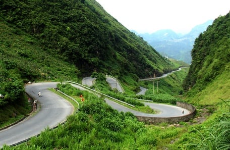
But our feeling of "being transported to the moon" had to "fall back down" as we gripped the steering wheel firmly, climbing the treacherous, nine-curved mountain pass that is both terrifying and beloved by adventurers and conquerors: the Tham Ma Pass. The car shifted gears constantly on the "steep, winding slope," yet we always felt like we were being left behind. The Tham Ma Pass is understood to be a slope used to test the strength of a horse.
 |
| Two little girls jump rope and play on top of Tham Ma slope. |
Legend has it that, in the old days, people used horses to carry goods up this very slope. Any horse that reached the top still strong was considered a good horse and would be kept by the locals. Horses that were weak and out of breath after the climb would be served with a pot of thang co (a traditional stew) at the highland markets.
Today, these powerful motorcycles have conquered not only the Tham Ma Pass but also one mountain peak after another across the rocky plateau. Among them, the Ma Pi Leng Pass – a route that tempts adventurous riders – looks from afar like a thread stretched across the steep rocky mountains.
But beyond the "fear," lies a breathtakingly beautiful and majestic mountain landscape! In the Hmong language, "Ma Pi Leng" means "horse's nose," referring to the most treacherous road, with steep slopes resembling a horse's nose. Along this 20km mountain pass connecting Dong Van and Meo Vac districts, visitors feel like they are traveling through a science fiction movie.
The road named Happiness Road was started on September 10, 1959, with the participation of more than 1,300 volunteer youth and over 1,000 laborers from 16 ethnic groups including H'Mong, Tay, Dao, Pu Peo, Lo Lo, etc.
The stone monument at the top of the pass records the milestones in the construction of the road, and also serves as a memorial to those who sacrificed their lives. To build the road, thousands of laborers toiled day and night, chiseling through the rock. The 2km stretch through the cliffs at the top of Ma Pi Leng Pass was built by young men risking their lives, hanging from the mountainside, inch by inch, over 11 months. Their unwavering determination, embodying the spirit of "our own hands can create anything," in the face of the harsh and treacherous terrain, has given the border plateau region a new face today!
Compared to the original mountain pass, which was only wide enough for pedestrians and horse-drawn carts, the Happiness Road is now wide, easy to navigate, and can accommodate large vehicles. Many sections are currently being widened and repaired. Standing on the summit of Ma Pi Leng, one feels incredibly small in the face of nature, and the Happiness Road is truly an extraordinary masterpiece created by humankind.
Many ways to explore the rocky plateau. From Ha Giang City, you can rent a motorbike for 180,000-350,000 VND/day (depending on the type of motorbike). Rental shops are quite professional and usually maintain and inspect the motorbikes thoroughly before handing them over to customers. You need to pack your luggage neatly, secure it firmly to the motorbike, and importantly, fill up the gas tank before heading up the plateau. Tourists can take a bus to the rocky plateau or hire a car for 2 days and 1 night for about 2,500,000 VND. |
Text and photos: TRAN PHUOC
>> Next episode: From the top of Lung Cu flagpole to the deep Tu San gorge
Source link


Comment (0)