

 |
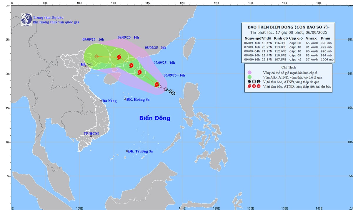
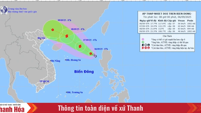
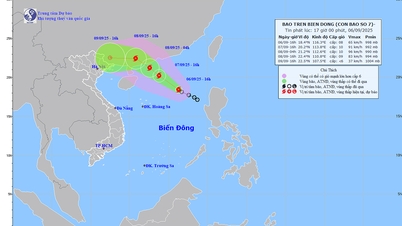
| Storm news in the East Sea (storm number 7). Photo: KTTV |
According to the National Center for Hydro-Meteorological Forecasting, on the afternoon of September 6, the tropical depression in the eastern sea of the North East Sea strengthened into a storm (storm No. 7). At 4:00 p.m. on September 6, the center of the storm was located at 18.4 degrees North latitude, 116.3 degrees East longitude, in the North East Sea, with the strongest wind at level 8, gusting to level 10; moving northwest at a speed of 15km/h and continuing to strengthen.
To proactively respond to the storm, the Minister of Agriculture and Environment requested ministries, branches and People's Committees of coastal provinces and cities from Quang Ninh to Dak Lak to closely monitor the storm's developments; strictly manage means of transport going out to sea; organize counting and notify owners of means of transport, captains of ships and boats operating at sea of the location, direction of movement and developments of the storm so that they can proactively avoid, escape or not move into dangerous areas. Dangerous areas in the next 24 hours: From 17 - 22 degrees North latitude, 112 - 117.5 degrees East longitude (dangerous areas are adjusted in forecast bulletins).
Ministries, sectors and localities are ready with forces and means for rescue when requested. Ministries and sectors, according to their functions, state management tasks and assigned tasks, proactively direct and coordinate with localities to respond to the storm.
Vietnam News Agency, Vietnam Television, Voice of Vietnam and the coastal information station system and mass media agencies from central to local levels should increase information about the storm's developments to authorities at all levels, owners of means of transport operating at sea and people to proactively prevent and respond.
The above units organize serious duty and regularly report to the Ministry of Agriculture and Environment (through the Department of Dyke Management and Disaster Prevention and Control).
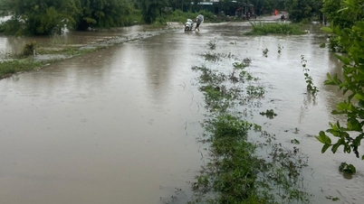
Along with that, according to the National Center for Hydro-Meteorological Forecasting, from 6:30 p.m. to 11:30 p.m. on September 6, the areas of Quang Ngai and Lam Dong provinces continued to have rain with common accumulated rainfall such as Quang Ngai from 10-20mm, some places over 50mm; Lam Dong from 10-30mm, some places over 70mm.
Warning of the risk of flash floods on small rivers and streams, landslides on steep slopes in the above provinces, especially in the communes/wards: Dak Long, Dak Sao, Dak To, Dak To Kan, Duc Nong, Kon Dao, Ngok Tu (Quang Ngai province); Cu Jut, Dak Wil, Dam Rong 3, Dam Rong 4, Duc Lap, Lac Duong, Nam Dong, Thuan An (Lam Dong province).
Warning level of natural disaster risk due to flash floods, landslides, land subsidence due to heavy rain or level 1 flow.
Flash floods and landslides can have very negative impacts on the environment, threaten people's lives; cause local traffic congestion, affect the movement of vehicles; destroy civil and economic works, causing damage to production and socio-economic activities.
The hydrometeorological agency recommends that local authorities pay attention to reviewing bottlenecks and vulnerable locations in the area to take preventive and response measures.
From 3:00 p.m. to 5:00 p.m. on September 6, the provinces of Quang Ngai and Lam Dong had moderate to heavy rain such as: Ngok Tu 1 (Quang Ngai) 58mm; Truc Son (Lam Dong) 33.8mm, Dak Drong (Lam Dong) 32.6mm;...
Soil moisture models show that some areas in the above provinces are close to saturation (over 85%) or have reached saturation.
Source: https://baothainguyen.vn/tai-nguyen-moi-truong/202509/tu-quang-ninh-den-dak-lak-chu-dong-ung-pho-voi-bao-so-7-c9f200f/

![[Photo] Prime Minister Pham Minh Chinh attends the 80th Anniversary of the Vietnam Posts and Telecommunications Group](https://vphoto.vietnam.vn/thumb/1200x675/vietnam/resource/IMAGE/2025/9/6/39a89e5461774c2ca64c006d227c6a4e)

![[Photo] Rescuing people in flooded areas at the foot of Prenn Pass overnight](https://vphoto.vietnam.vn/thumb/1200x675/vietnam/resource/IMAGE/2025/9/6/19095b01eb844de98c406cc135b2f96c)
![[Photo] 80th Anniversary of the General Staff of the Vietnam People's Army](https://vphoto.vietnam.vn/thumb/1200x675/vietnam/resource/IMAGE/2025/9/6/49153e2a2ffc43b7b5b5396399b0c471)
![[Photo] General Secretary To Lam attends the 80th Anniversary of the General Staff of the Vietnam People's Army](https://vphoto.vietnam.vn/thumb/1200x675/vietnam/resource/IMAGE/2025/9/6/126697ab3e904fd68a2a510323659767)


![[Photo] Many people directly experience beloved Uncle Ho and the General Secretaries](https://vphoto.vietnam.vn/thumb/1200x675/vietnam/resource/IMAGE/2025/9/6/2f4d9a1c1ef14be3933dbef3cd5403f6)


Comment (0)