
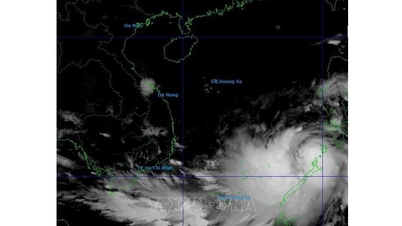
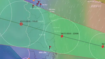
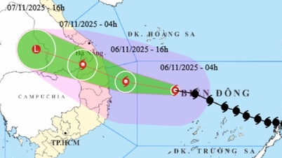
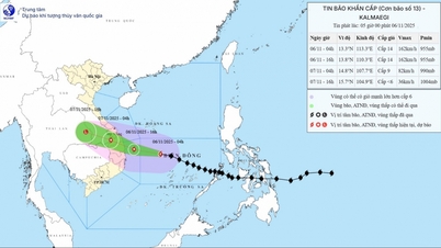
Location and path of the tropical depression. (Source: National Center for Hydro-Meteorological Forecasting)

On the afternoon of September 6, Head of the Weather Forecast Department - National Center for Hydro-Meteorological Forecasting Nguyen Van Huong said that the current operating conditions of the tropical depression are quite favorable for development, with the sea surface temperature in the northern part of the East Sea, the area above 15 degrees North latitude currently at 29-30 degrees Celsius and in the area of the tropical depression's operation, the wind shear is also small, plus the southwest wind in the South is relatively strong. Therefore, the possibility of this tropical depression strengthening into a storm is up to 70-80%.
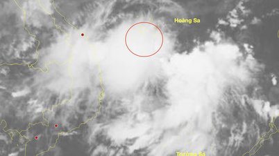
It is forecasted that in the evening and night of September 6, the tropical depression will strengthen into a storm.
If it strengthens into a storm, this will be the 16th storm in the Northwest Pacific region and the 7th storm active in the East Sea with the international name Tapah.
This tropical depression/storm formed in the northern part of the East Sea, while the subtropical high pressure tongue, the main shape that determines the path and direction of tropical depressions/storms, tends to weaken.
This tropical depression/storm is located on the western part of the subtropical ridge. According to the track trend, the storm will move mainly northwest.
With this direction of movement, the possibility of the storm moving deep into our mainland is not high, but the possibility of the storm making landfall in China.
"Currently, forecasts from international storm forecasting centers predict that this storm will make landfall in Guangdong province (China) on September 8. When it makes landfall, the storm's intensity could reach level 10-11, gusting to level 13-14," said Mr. Nguyen Van Huong.
"Vietnam's forecast is quite similar to international forecasts. Vietnam believes that in the evening and night of September 6, this tropical depression will strengthen into a storm (storm number 7). The strongest intensity when approaching the mainland coast of Guangdong province (China) will reach level 10, gusting to level 13 and the time of landfall in China will be around the morning and noon of September 8," Mr. Nguyen Van Huong emphasized.
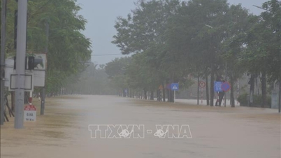
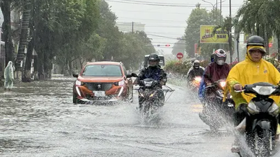
Mr. Nguyen Van Huong noted that although it made landfall in China, after making landfall, storm No. 7 will quickly weaken into a low-pressure area, then move westward toward our country and it is likely that from the afternoon and night of September 9-11, the post-storm No. 7 circulation will cause widespread heavy rain in the North, focusing on the midland and mountainous areas of the Northeast./.
According to Vietnamplus
Source: https://www.vietnamplus.vn/ap-thap-nhiet-doi-se-manh-len-thanh-bao-so-7-huong-ve-dat-lien-trung-quoc-post1060281.vnp
Source: https://baolongan.vn/ap-thap-nhiet-doi-se-manh-len-thanh-bao-so-7-huong-ve-dat-lien-trung-quoc-a202044.html


![[Photo] Panorama of the Patriotic Emulation Congress of Nhan Dan Newspaper for the period 2025-2030](https://vphoto.vietnam.vn/thumb/1200x675/vietnam/resource/IMAGE/2025/11/04/1762252775462_ndo_br_dhthiduayeuncbaond-6125-jpg.webp)

![[Photo] Opening of the 14th Conference of the 13th Party Central Committee](https://vphoto.vietnam.vn/thumb/1200x675/vietnam/resource/IMAGE/2025/11/05/1762310995216_a5-bnd-5742-5255-jpg.webp)


Comment (0)