

To learn more about this issue, VNA reporter had an interview with Associate Professor, PhD, Director of the National Center for Hydro-Meteorological Forecasting Mai Van Khiem.
What are the current developments and characteristics of the storm, sir?
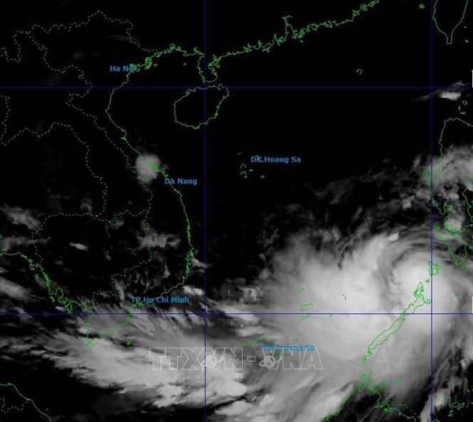
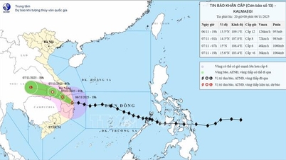
At 5:00 a.m. on November 5, storm KALMAEGI crossed the northern area of Palaoan Island of the Philippines and entered the eastern sea of the central area of the East Sea, becoming storm number 13, with intensity of level 13 and gusts of level 16.
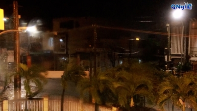
It is forecasted that around the afternoon of November 6, the storm will enter the sea area of Da Nang city and Khanh Hoa province. Around the night of November 6 (after 9 p.m.) to the early morning of November 7, the storm will make landfall in the provinces from Quang Ngai to Dak Lak, then move to Laos, weaken into a tropical depression and gradually dissipate.
This is considered a strong storm moving quickly, with a wide storm circulation, operating on the tropical convergence zone, with high sea surface temperatures, a humid atmosphere, and cold air in a weakening period. Therefore, the storm is likely to strengthen after entering the East Sea.
The Vietnam Hydrometeorological Agency has discussed the forecast with the Japan Meteorological Agency, the China Meteorological Agency, Taiwan (China), and the Japan Weather News. According to the discussion, the international and Vietnamese forecasts are relatively consistent in terms of trajectory and intensity, which is that the area entering the East Sea can reach level 13, gusting to level 16. After that, the storm will move towards the Vietnamese mainland, focusing on the provinces and cities from Da Nang to Dak Lak . The path and impact of storm No. 13 are similar to storm No. 12 - (Damrey) in 2017 and storm No. 9 (Molave) in 2020.
So, how will storm 13 affect sea and land areas?
Due to the impact of the storm, the central East Sea area, including the sea area north of Truong Sa special zone, the wind gradually increased to level 7-8, then increased to level 9-11. The area near the storm's center had strong winds of level 12-14, gusting to level 17, waves 5-7m high and the area near the storm's center had waves 8-10m high, with rough seas. However, it is necessary to pay close attention to the impacts of strong winds on Truong Sa special zone and marine structures.
From early morning on November 6, the sea area from Da Nang city to Khanh Hoa including Ly Son special zone, the wind gradually increased to level 6-7, then increased to level 8-11, the area near the storm center passed through strong level 12-14, gusting to level 17. The coastal area from Hue city to Dak Lak had waves 4-6m high, the area near the storm center was 6-8m high, the sea was very rough. It should be noted that the wind is very strong in Ly Son special zone.
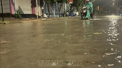
From the evening of November 6, coastal areas from Hue city to Dak Lak are on guard against sea level rise of 0.3-0.6m, accompanied by large waves and during high tide, which can cause flooding in low-lying areas, waves overflowing dikes, coastal roads, coastal landslides, slowing down flood drainage in the area. All ships, boats, and aquaculture areas in the above-mentioned dangerous areas are strongly affected by storms, whirlwinds, strong winds, large waves and rising sea levels.
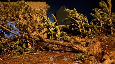
On land from the evening of November 6, on the mainland along the coast from South Quang Tri to Da Nang city, in the East of the provinces from Quang Ngai to Dak Lak, the wind will gradually increase to level 6-7, then increase to level 8-9. The area near the eye of the storm will be strong at level 10-12 (focusing on the East of Quang Ngai and Dak Lak provinces), gusting at level 14-15. The strongest wind will be from the evening of November 6 to the morning of November 7. In the West of Quang Ngai and Gia Lai provinces, the wind will gradually increase to level 6-7, the area near the eye of the storm will be strong at level 8, gusting at level 10.
Due to the impact of the wide storm circulation, local authorities and people in the affected areas need to be on guard against the risk of thunderstorms, tornadoes and strong gusts of wind both before and during the storm's landfall.
How will storms and storm circulation cause rain and floods on rivers?
The cold air is currently weakening, and there are no signs of it strengthening again on November 6-7. During this time, the activity of the easterly wind zone is not strong due to the impact of a very strong storm that has just appeared in the East Philippines, so this rain is mainly due to the circulation of storm No. 13.
From November 6-7, the area from Da Nang city to Dak Lak will have very heavy rain with common rainfall of 200-400mm/period, locally over 600mm/period; the area from South Quang Tri to Hue city, Khanh Hoa and Lam Dong will have heavy to very heavy rain with common rainfall of 150-300mm/period, locally over 450mm/period. From November 8, heavy rain in the above areas will tend to decrease.
From November 7-8, the area from North Quang Tri to Thanh Hoa will have moderate to heavy rain with common rainfall of 50-150mm/period, locally very heavy rain over 200mm/period.
Due to the impact of storm No. 13 causing heavy rain, rivers from Quang Tri to Khanh Hoa are likely to experience a new flood; in which, the flood level and inundation on river systems in Hue city and Da Nang city are likely not as serious as the recent flood that occurred in the Central region.
Specifically, in Quang Tri province, Gianh and Thach Han rivers are above alert level 1, Kien Giang is above alert level 2. In Hue city, Bo and Huong rivers are from alert level 2 to alert level 3 and above alert level 3.
Da Nang City, Vu Gia - Thu Bon River is at alert level 2 to alert level 3, some places above alert level 3. Quang Ngai Province, Tra Khuc River, Ve River is at alert level 2 to alert level 3 and above alert level 3.
Gia Lai province, An Lao and Lai Giang rivers rose above alert level 2, Kon river rose to alert level 2-3, Se San river rose above alert level 2.
Dak Lak province, Ba river rises to alert level 2 to alert level 3, Ky Lo river rises above alert level 3, Srepok rises to alert level 2 to alert level 3.
Khanh Hoa province, Dinh Ninh Hoa river rises above alert level 2, Cai Nha Trang river rises above alert level 1.
What recommendations do you have for the government and people, sir?
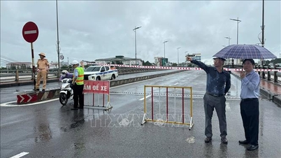
Local authorities and people must immediately strictly comply with the instructions of all levels, the National Civil Defense Steering Committee, the Ministry of Agriculture and Environment, relevant ministries and branches... in responding to storms, storm circulation, heavy rain, high floods....
People should absolutely not be subjective and limit going out when the storm makes landfall. Localities must closely monitor developments and proactively deploy response measures to minimize damage....
The government and people closely monitor the developments of natural disasters of hydrometeorological origin at https://www.nchmf.gov.vn/kttv of the National Center for Hydro-Meteorological Forecasting, provincial, municipal and regional hydro-meteorological stations and information on official mass media of the central and local levels.
Thank you very much!
Source: https://baotintuc.vn/van-de-quan-tam/tien-si-mai-van-khiem-bao-so-13-rat-manh-du-bao-gay-mua-rat-lon-tu-da-nang-den-dak-lak-20251105094116488.htm
![[Photo] Prime Minister Pham Minh Chinh receives the delegation of the Semiconductor Manufacturing International (SEMI)](https://vphoto.vietnam.vn/thumb/1200x675/vietnam/resource/IMAGE/2025/11/06/1762434628831_dsc-0219-jpg.webp)
![[Photo] Closing of the 14th Conference of the 13th Party Central Committee](https://vphoto.vietnam.vn/thumb/1200x675/vietnam/resource/IMAGE/2025/11/06/1762404919012_a1-bnd-5975-5183-jpg.webp)


Comment (0)