
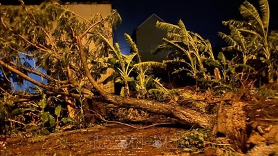
Many areas have strong winds
Due to the influence of the storm, at Ly Son station (Quang Ngai), there were strong winds of level 8, gusts of level 10; Hoi An (Da Nang) strong winds of level 8, gusts of level 10; Dung Quat (Quang Ngai) strong winds of level 8, gusts of level 9; Hoa Nhon Dong ( Gia Lai ) strong winds of level 8, gusts of level 10; Phu Cat (Gia Lai) strong winds of level 9, gusts of level 13; An Nhon (Gia Lai) strong winds of level 10, gusts of level 14; Hoai Nhon (Gia Lai) strong winds of level 7, gusts of level 9;
Quy Nhon (Gia Lai) strong winds level 7, gusts level 11; Canh Thuan (Gia Lai) strong winds level 7, gusts level 10; Son Hoa (Dak Lak) strong winds level 7, gusts level 10; Tuy Hoa (Dak Lak) strong winds level 6, gusts level 9; Song Cau (Dak Lak) strong winds level 9; An Khe (Gia Lai) strong winds level 6; Cheo Reo (Gia Lai) strong winds level 7, gusts level 8; M Dak (Dak Lak) strong winds level 7, gusts level 10.
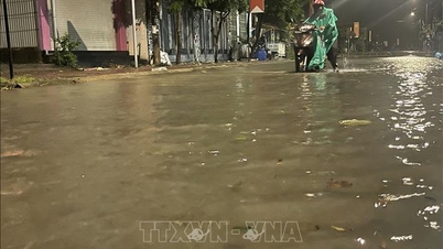
In the area from Hue city to Khanh Hoa, there was heavy rain, some places over 170mm such as: Xuan Son Nam station (Dak Lak) 243mm, Dak Pling (Gia Lai) 185mm, Tra Thanh (Quang Ngai) 203mm, ...
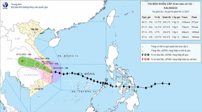
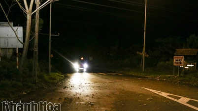
At 7:00 p.m. on November 6, the eye of the storm was at about 13.5 degrees North latitude; 109.1 degrees East longitude, on the mainland along the coast of Gia Lai-Dak Lak province. The strongest wind near the eye of the storm was level 12 (118-133 km/h), gusting to level 14. Moving in the West Northwest direction, speed about 30 km/h.
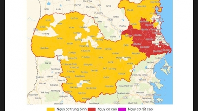
At 1:00 a.m. on November 7, the storm on land in the area from Quang Ngai to Dak Lak , the strongest wind is level 8, gusting to level 10, moving in the West Northwest direction at a speed of 30 km/h and moving deep into the mainland and gradually weakening. The affected area is the sea from Quang Ngai to Dak Lak (including Ly Son special zone); the mainland to the East of the area from Quang Ngai to Gia Lai, North of Dak Lak, natural disaster risk level 4.
The western part of the central East Sea, the sea area from South Quang Tri to Da Nang city (including Cu Lao Cham island) and Khanh Hoa; the mainland from South Quang Tri to Da Nang city, the southern part of Dak Lak province and the northern part of Khanh Hoa province with level 3 natural disaster risk.
It is forecasted that by 7:00 a.m. on November 7, the storm in the Southern Laos area, with the strongest wind force of 6, gusting to level 8, will move in the West Northwest direction at a speed of 30 km/h and gradually weaken into a tropical depression. The affected area is the sea from Southern Quang Tri to Da Nang city (including Ly Son special zone, Cu Lao Cham island) and Khanh Hoa; mainland from Southern Quang Tri to Da Nang city, Southern Dak Lak province and Northern Khanh Hoa province with a level 3 natural disaster risk level.
Then, at 10:00 a.m. on November 7, the tropical depression in the eastern part of Thailand moved west-northwest at a speed of 25-30 km/h, with winds below level 6, and weakened into a low-pressure area. Due to the influence of the storm, the western part of the central East Sea had strong winds of level 6-8, gusts of level 10, waves 3-5m high; rough seas.
The sea area from South Da Nang to Dak Lak (including Ly Son special zone, Cu Lao Cham island) has strong winds of level 8-9, waves 3-5m high; the area near the storm center has strong winds of level 10-12, gusts of level 14, waves 5-7m high; the sea is very rough.
The sea area from South Quang Tri to North Da Nang and Khanh Hoa has strong winds of level 6-7, gusts of level 8-9, waves 2-4m high; rough seas.
The highest sea level in Thuan An is 1m, Son Tra is 1.2m, Hoi An is 1.3m, Dung Quat is 1.5m, Quy Nhon is 1.2m, Tuy Hoa is 1.1m.
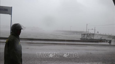
Warning, coastal areas from South Quang Tri - Dak Lak are on guard against sea level rise of 0.5-1m accompanied by big waves causing flooding in low-lying areas, waves overflowing dikes, coastal roads, coastal landslides, slowing down flood drainage in the area. All ships, boats, and aquaculture areas in the above-mentioned dangerous areas are strongly affected by storms, whirlwinds, strong winds, big waves and rising sea levels.
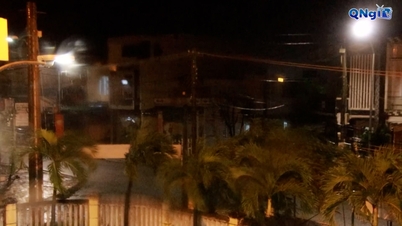
From the south of Da Nang city to Dak Lak, the wind is strong at level 6-9, the area near the storm's eye is strong at level 10-12 (focusing on the east of Quang Ngai-Gia Lai provinces, the north of Dak Lak), gusting at level 14; the area from the south of Quang Tri to the north of Da Nang city and the north of Khanh Hoa province, the wind is strong at level 6-7, gusting at level 8-9. The strongest wind time is from the evening to the night of November 6.
In the West, from Quang Ngai to Dak Lak provinces, there are strong winds of level 6-7, near the storm's eye, there are strong winds of level 8-9, gusting to level 11.
From the evening of November 6-7, the area from Da Nang city to Dak Lak will have very heavy rain with common rainfall of 150-300mm, locally over 450mm; the area from South Quang Tri to Hue city, Khanh Hoa and Lam Dong will have heavy rain with common rainfall of 100-250mm, locally over 400mm. From November 8, heavy rain in the above areas will tend to decrease.
From November 7-8, the area from Thanh Hoa to Northern Quang Tri will have moderate to heavy rain with common rainfall of 50-150mm, locally very heavy rain over 200mm. Warning of risk of heavy rain over 200mm/3 hours.
Due to the influence of the wide storm circulation, it is necessary to guard against the risk of thunderstorms, tornadoes and strong gusts of wind both before and during the storm's landfall.
Director of the National Center for Hydro-Meteorological Forecasting Mai Van Khiem said that the path and impact of storm No. 13 is similar to storm No. 12 - (Damrey) in 2017 and storm No. 9 (Molave) in 2020, but storm No. 13 causes heavier rain in the area from Da Nang city to Dak Lak.
Storm No. 12 - (Damrey) in 2017, when making landfall in the provinces of Phu Yen and Khanh Hoa, had a strong intensity of level 9, causing heavy rain in the Hue - Khanh Hoa area from 150 - 250mm, Gia Lai - Dak Lak about 80 - 150mm; some places had heavier rain such as: Nam Dong (Hue) 321mm; Tam Ky, Tien Phuoc (old Quang Nam) 280mm; Ba To (Quang Ngai) 338mm; Son Giang (Quang Ngai) 382mm; An Nhon (Gia Lai) 296mm, Quy Nhon (Gia Lai) 295mm; An Khe (Gia Lai) 266mm, Krong Pa (Gia Lai) 237mm;...
Storm No. 9 (Molave) in 2020 when making landfall in the Quang Ngai - Da Nang area had a strong intensity of level 11 - 12, gusting to level 14. The storm caused heavy rain from 150-400mm in many places from Nghe An to Dak Lak, some stations measured rainfall of over 550mm.
Proactively respond to storm No. 13
According to information from the Department of Dyke Management and Natural Disaster Prevention and Control (Ministry of Agriculture and Environment), as reported by the Border Guard Command, as of 4:30 p.m. on November 6, 61,475 vehicles/291,384 workers had been notified, counted, and instructed. Currently, there are no vehicles in the danger zone.
Localities have issued sea bans such as Da Nang (sea ban from 3pm on November 5), Quang Ngai (sea ban from 7pm on November 5), Dak Lak (sea ban from 6am on November 5), Khanh Hoa (sea ban from 12pm on November 6), Gia Lai (sea ban from 5pm on November 5).
The provinces from Da Nang to Khanh Hoa have about 38 km of embankments to protect against coastal erosion. Currently, along the coast of the provinces, there are some areas with erosion or at risk of erosion such as Cua Dai, Hoi An (Da Nang), An My (Dak Lak), etc.
As of 4:00 p.m. on November 6, localities had evacuated 128,974 households/537,112 people, of which Hue had 151 households/657 people, Da Nang had 2,241 households/6,074 people, Quang Ngai had 30,490 households/89,738 people; Gia Lai had 93,426 households/339,737 people, Dak Lak had 2,666 households/7,661 people and evacuated and reinforced 93,245 cages (Quang Ngai, Gia Lai and Dak Lak provinces have completed evacuation as planned).
Quang Ngai, Dak Lak, Khanh Hoa, and Gia Lai provinces let students stay home from school on November 6-7.
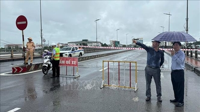
In the field of transportation, there are currently 15 traffic jams and flooding locations on national highways passing through the provinces and cities of Hue, Da Nang and Quang Tri.
Gia Lai province banned all vehicles from traveling on the road from 5 p.m. on November 6; banned the road on the Da Nang - Quang Ngai expressway from 6:30 p.m. on November 6; Quang Ngai province restricted traffic from 4 p.m. on November 6.
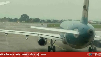
The aviation sector temporarily suspends services at 6 airports (Phu Cat, Chu Lai, Tuy Hoa, Pleiku, Buon Ma Thuot, Lien Khuong).
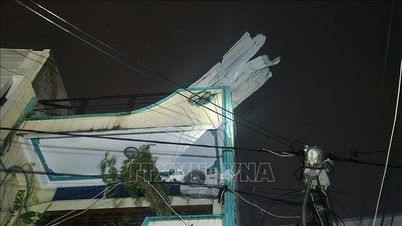
Due to the impact of the storm, on November 6, two people were injured while reinforcing houses and moving furniture in Quy Nhon ward and Tuy Phuoc commune, Gia Lai province.
Source: https://baotintuc.vn/xa-hoi/bao-so-13-giam-cuong-do-tren-dat-lien-ven-bien-tinh-gia-lai-dak-lak-20251106205652758.htm
![[Photo] Closing of the 14th Conference of the 13th Party Central Committee](https://vphoto.vietnam.vn/thumb/1200x675/vietnam/resource/IMAGE/2025/11/06/1762404919012_a1-bnd-5975-5183-jpg.webp)
![[Photo] Prime Minister Pham Minh Chinh receives the delegation of the Semiconductor Manufacturing International (SEMI)](https://vphoto.vietnam.vn/thumb/1200x675/vietnam/resource/IMAGE/2025/11/06/1762434628831_dsc-0219-jpg.webp)


Comment (0)