
 |
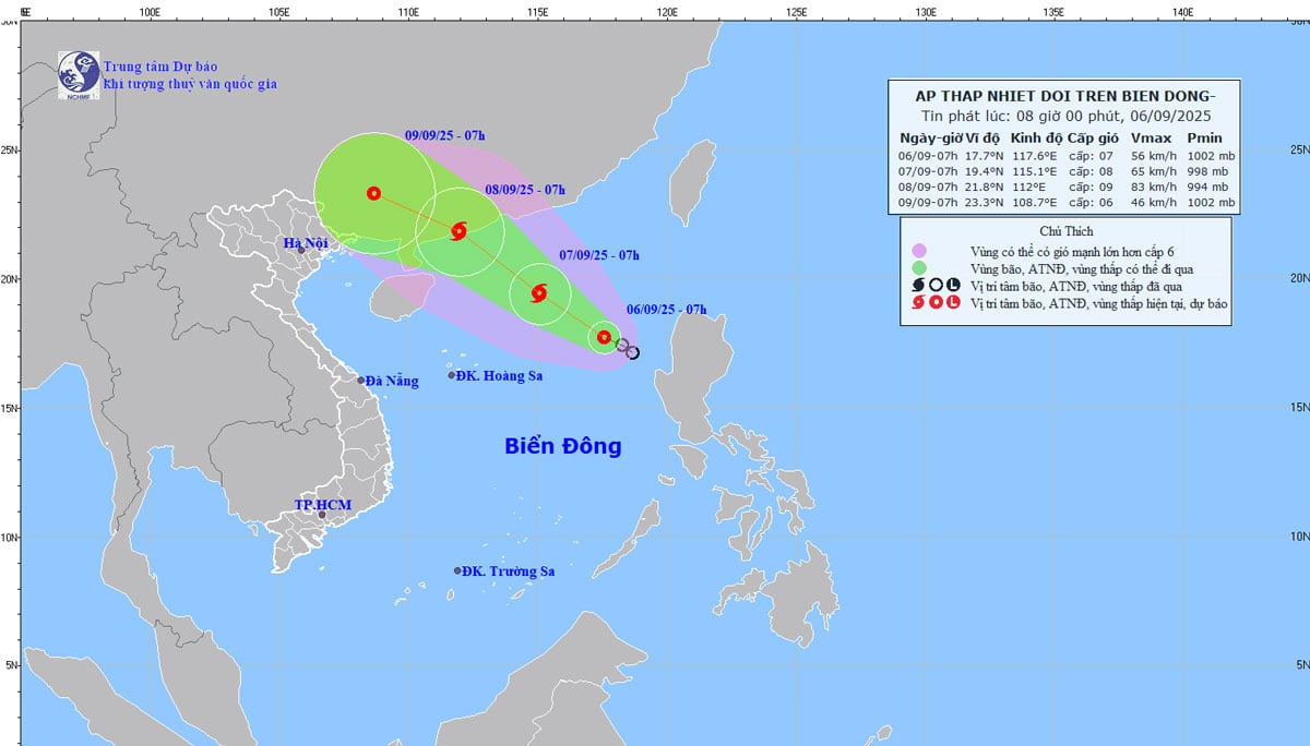
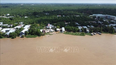
| Location and path of the tropical depression at 8 a.m. on September 6. Photo: KTTV |
According to the National Center for Hydro-Meteorological Forecasting, on the morning of September 6, a tropical depression was active in the eastern sea of the northern part of the East Sea, with a strong intensity of level 7.
According to experts, the current operating conditions of the tropical depression are quite favorable for development, with the sea surface temperature in the northern part of the East Sea, the area above 15 degrees North latitude is at 29 - 30 degrees Celsius; in the area of operation of the tropical depression, the wind shear is also small, plus the southwest wind is relatively strong, so the possibility of this tropical depression strengthening into a storm is up to 70 - 80%.
Meteorological experts note that this tropical depression/storm is forming in the northern part of the East Sea, while the subtropical high pressure tongue, the main shape that determines the path and direction of tropical depressions/storms, is weakening, so the storm will mainly move in the northwest direction.
"With the northwest direction of movement, the possibility of the storm moving deep towards our mainland is not high, the possibility of the storm making landfall in China. Currently, forecasts from international storm forecasting centers say that this storm will make landfall in China's Guangdong province on September 8. When it makes landfall, the intensity of the storm can reach level 10 - 11, gusting to level 13 - 14," said a representative of the National Center for Hydro-Meteorological Forecasting.
Vietnam's forecast is quite similar to international forecasts. Vietnam believes that in the evening and night of September 6, this tropical depression will strengthen into a storm (storm number 7). Its strongest intensity when approaching the mainland coast of Guangdong province (China) will reach level 10, gusting to level 13, and it will make landfall in China around the morning and noon of September 8.
Although making landfall in China, after making landfall, storm No. 7 will quickly weaken into a low pressure area, then drift westward, towards our country. It is likely that from the afternoon and night of September 9 to September 11, the post-storm circulation of storm No. 7 will cause widespread heavy rain in the North, focusing on the midland and mountainous areas of the Northeast.
Source: https://baothainguyen.vn/tai-nguyen-moi-truong/202509/ap-thap-nhiet-doi-du-bao-se-manh-len-thanh-bao-so-7tren-bien-dong-e0576fd/
![[Photo] Da Nang: Water gradually recedes, local authorities take advantage of the cleanup](https://vphoto.vietnam.vn/thumb/1200x675/vietnam/resource/IMAGE/2025/10/31/1761897188943_ndo_tr_2-jpg.webp)
![[Photo] Prime Minister Pham Minh Chinh attends the 5th National Press Awards Ceremony on preventing and combating corruption, waste and negativity](https://vphoto.vietnam.vn/thumb/1200x675/vietnam/resource/IMAGE/2025/10/31/1761881588160_dsc-8359-jpg.webp)


Comment (0)