
And every time, those in charge always make promises and commitments that flooding will end in this or that place within a certain period of time. But the flooding problem continues year after year, after flooding in one place, it moves to another, and for more than two decades, flooding has been a “known, painful, and talked about issue”…
At the end of the rainy season in 2024, the Ho Chi Minh City Department of Construction compiled that Ho Chi Minh City still had 30 flooded roads, with the water receding 30 minutes earlier. District 1 has 11 roads including: Calmette, Nguyen Cu Trinh, Cong Quynh, Nguyen Van Cu, Le Lai, Le Thanh Ton, Truong Dinh, Le Loi, Pham Ngu Lao, Pham Viet Chanh, Le Thi Rieng. Go Vap has 4 routes: Pham Van Chieu, Le Van Tho, Le Duc Tho, Phan Huy Ich. Binh Thanh has Ung Van Khiem, Dinh Bo Linh, Bach Dang, Binh Quoi routes.
Binh Tan District has 3 roads: Tan Hoa Dong, Phan Anh, An Duong Vuong. District 12 has Phan Van Hon and Nguyen Van Qua streets. Hoc Mon District has 2 roads: Song Hanh National Highway 22 and Ba Trieu... Those are only the routes with a 30-minute cut-off time, but there are still many routes with a 30-minute cut-off time, of which Thu Duc Market (Thu Duc City) is a typical example.
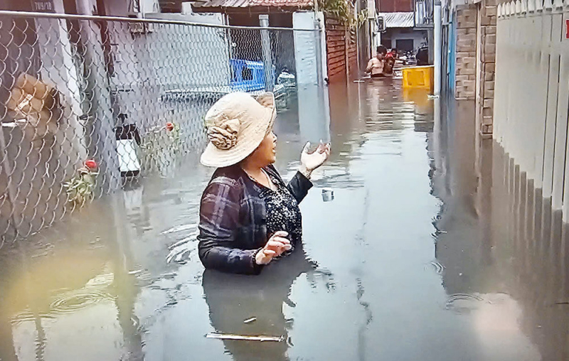
The heavy rain of more than 150mm on the morning of May 10, 2025 clearly reflected that many places in and around Ho Chi Minh City were deeply flooded, many people had to leave work because they could not move through the heavily flooded roads. Of course, the flooded locations were still the roads indicated by the Department of Construction.
Some places, such as Dang Thuy Tram Street (Binh Thanh District), were heavily flooded over a 1km stretch, with water nearly 1m deep, and motorbikes had to be pushed on foot. Roads around Thu Duc Market such as Kha Van Can, Duong Van Cam, Le Van Ninh, and Dang Thi Ranh were deeply flooded, and motorbikes could not pass. Due to the strong water pressure, many manhole covers were blown up, creating a feeling of extreme fear for passersby.
According to Mr. Nguyen Quang Chi, Deputy Head of the Traffic and Public Works Department (Thu Duc City People's Committee), Thu Duc market area is in the transition area from the hilly area bordering Binh Duong province towards the Saigon riverside area, the terrain elevation varies from +30.0m down to +0.50m, with a large slope, in which Thu Duc market area has a low elevation from +0.6m to +1m.
The current drainage system of Thu Duc market area is mainly a small circular sewer system that has been invested for many years, with poor drainage capacity; canals, ditches, and ditches around Thu Duc market area are often filled with sand and soil, and the situation of dumping garbage and solid waste into canals, ditches, and ditches still exists, causing poor water storage capacity, limiting drainage capacity.
Through inspection and review, the current flooding status of the roads in Thu Duc market area (Duong Van Cam, Dang Thi Ranh, Le Van Ninh, Kha Van Can streets) after rains with rainfall of 60mm or more combined with high tides has a flooding depth of about 20-50cm.
According to Mr. Nguyen Quang Chi, due to the low-lying terrain, the Thu Duc market area is a basin area, receiving water flowing from all directions to drain into Cau Ngang canal and Thu Duc canal. However, at Cau Ngang (on Kha Van Can street intersecting with Cau Ngang canal) with a narrow width of about 5.3m, it is a "bottleneck" position, water cannot drain into Thu Duc canal in time, causing flooding.
At the same time, due to the high urbanization and concreting process, the natural rainwater catchment basin's cover (easy to absorb water) has fundamentally changed. Up to now, most of it has lost its ability to absorb water, leading to an increase in peak rain flow, causing the drainage system around Thu Duc market area to become overloaded.
To overcome this situation, Thu Duc City People's Committee has implemented many construction items such as dredging the drainage system of Le Van Ninh Street, dredging and clearing the Cau Ngang canal, operating all the tide-prevention valves on Cau Ngang canal to ensure rapid drainage for Duong Van Cam Street, Linh Tay Ward (especially at the automatic tide-prevention valve at the end of alley 91 of Duong Van Cam Street). Checking, dredging and clearing the drainage system of Vo Van Ngan Street so that water collection and drainage are ensured according to the approved design. Maintaining and dredging the drainage system of Duong Van Cam Street, Dang Thi Ranh Street, Kha Van Can Street section...
At the same time, continue to implement the Project to Improve the drainage system in Thu Duc market area (Duong Van Cam, Dang Thi Ranh, Kha Van Can and Ho Van Tu streets) which is currently undergoing bidding and is expected to be completed in the fourth quarter of 2025; the project to build a new Cau Ngang Canal; upgrade the surface of Tam Tam Xa Street, Alley 14 Tam Tam Xa Street and Alley 57 Duong Van Cam Street; dredging and renovating Cau Ngang Canal, which is undergoing procedures for acceptance of the project and putting it into use, and is expected to be completed in July 2025...
However, people around Thu Duc market still do not believe that their houses will not be flooded when it rains heavily. Because before, when the Vo Van Ngan drainage project with a budget of 248 billion VND was completed, it was thought that it would fundamentally solve the flooding problem in Thu Duc market area, but in the end, just one early rain of the season (2024) turned Thu Duc market into a river...
Perhaps a study by a group of authors from the Southern Hydrometeorological Station will answer this question clearly. According to the above group of authors, the objective cause of flooding in Ho Chi Minh City is heavy rain and high tides in the East Sea. In addition, land subsidence due to excessive exploitation of groundwater has lowered the ground of Ho Chi Minh City, leading to increased flooding.
According to many measurement and cumulative research results from 1990 to 2022, Ho Chi Minh City has sunk about 1m. Of which, 10 districts with significant subsidence are 7, 8, 12, Go Vap, Tan Binh, Binh Thanh, Phu Nhuan, Binh Tan and Thu Duc City. Tan Binh and District 12 are recorded to have the largest subsidence...
The subjective cause is that urbanization significantly reduces the permeable surface. Urbanization also causes the disappearance of natural streams, the basins are divided into new basins. Another important thing is that urbanization creates much larger overflows than before. Replacing canals with sewers is one of the major causes of natural stream destruction, affecting water.
The river, canal and ditch system in Ho Chi Minh City is gradually narrowing, most of which have been silted up, blocking the flow, causing flooding. Dredging and clearing the flow of canals and ditches is still very limited. The situation of dumping garbage into canals, ditches and drainage system outlets is still very common, narrowing the flow, clogging the drainage system, manholes and discharge gates. Many places have been illegally encroached and filled, narrowing the flow, seriously affecting the drainage capacity of the area, especially many river, canal and ditch sections have been decommissioned.
The drainage system is overloaded, so it cannot meet the drainage needs, especially when there is heavy rain and prolonged rain. Planning work is still limited, flood prevention requires finding the cause of each flooding point, from which planning must be developed in sync with many sectors, long-term management and treatment plans must be invested synchronously according to the planning. Many approved plans are no longer suitable, but have not been supplemented or adjusted in time... In particular, the progress of project implementation is too slow, leading to the quality and conditions for implementing flood prevention solutions not meeting practical requirements...
Source: https://cand.com.vn/Giao-thong/vi-sao-nhieu-tuyen-duong-o-tp-ho-chi-minh-he-mua-la-ngap--i768883/


Comment (0)