
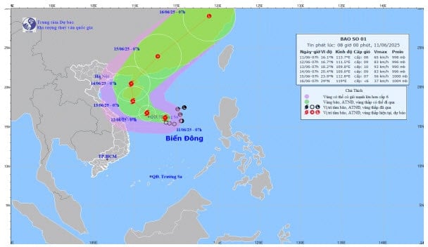
According to Mr. Mai Van Khiem, Director of the National Center for Hydro-Meteorological Forecasting, at 7:00 a.m. (June 11), the center of the storm was located at about 16.1 degrees North latitude; 113.7 degrees East longitude in the sea area east of Hoang Sa. The strongest wind near the center of the storm is level 8 (62 - 74 km/h), gusting to level 10; moving slowly in the West-Northwest direction at a speed of about 5 - 10 km/h.
The meteorological agency forecasts that at around 7:00 a.m. on June 12, the center of the storm will be at around 16.7 degrees North latitude; 111.5 degrees East longitude in the Hoang Sa sea area. The strongest wind near the center of the storm will be at level 9, gusting to level 11; moving in the West Northwest direction at a speed of around 10 km/h and is likely to strengthen further; affecting the entire North East Sea area (including the Hoang Sa sea area).
Forecast at 7:00 a.m. on June 13, the center of the storm is at about 18.2 degrees North latitude; 109.8 degrees East longitude in the area south of Hainan Island (China). The strongest wind near the center of the storm is level 10, gusting to level 13; moving northwest at a speed of about 5 - 10 km/h and is likely to strengthen; affecting the entire North East Sea area (including Hoang Sa sea area) and offshore waters from Quang Tri to Quang Ngai, and waters east of the Gulf of Tonkin.
Forecast at 7:00 a.m. on June 14, the center of the storm is at about 20.4 degrees North latitude; 109.6 degrees East longitude in the sea west of Leizhou Peninsula (China). The strongest wind near the center of the storm is level 9, gusting to level 12; moving north at a speed of about 5 - 10 km/h and gradually weakening; affecting the sea west of the North East Sea (including Hoang Sa sea), the sea east of the Gulf of Tonkin.
Due to the influence of storm No. 1, the North East Sea area (including Hoang Sa sea area), the North of the Central East Sea area has thunderstorms and strong winds of level 6 - 7, the area near the storm center has winds of level 8 - 9, gusts of level 11, waves 3 - 5 m high, very rough seas; the South of the Central East Sea area, the South East Sea area (including Truong Sa sea area) has strong southwest winds of level 6, sometimes level 7, gusts of level 8 - 9, waves 2 - 4 m high, rough seas.
The meteorological agency warns that ships operating in the above-mentioned dangerous areas are likely to be affected by storms, whirlwinds, strong winds, and large waves.
In addition, due to the influence of the storm circulation, from the night of June 11 to 13, the Central Central region will have moderate rain, heavy rain and thunderstorms, locally very heavy rain with common rainfall from 100 - 300 mm, some places over 450 mm. During the day and night of June 11, the South Central region will have moderate rain, heavy rain and thunderstorms, locally very heavy rain with common rainfall from 30 - 70 mm, some places over 150 mm.
Previously, on June 10, the Prime Minister issued Official Dispatch No. 86/CD-TTg requesting ministries, branches and localities to proactively respond to tropical depressions that are likely to strengthen into storms and floods.
The Prime Minister requested the Chairmen of the People's Committees of provinces and cities to closely monitor the developments of tropical depressions, storms, floods, and rains, proactively deploy response work appropriate to the specific situation in the locality, focusing on ensuring the safety of ships and vehicles at sea (including tourist boats); proactively evacuate households in areas at high risk of landslides, flash floods, and deep flooding to safe places; ensure the safety of key works, unfinished works, industrial parks, urban areas, residential areas, and production activities in low-lying areas.
Source: https://baohaiduong.vn/ap-thap-nhiet-doi-da-manh-len-thanh-bao-so-1-canh-bao-mua-lon-o-mien-trung-413760.html


Comment (0)