
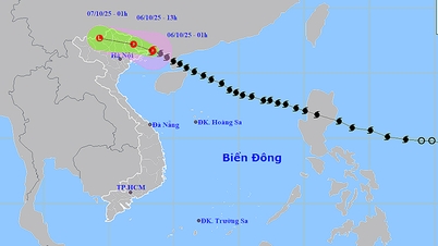
According to the National Center for Hydro-Meteorological Forecasting, at 7:00 a.m. this morning, August 19, the center of the tropical depression was located on the mainland of the Quang Ninh - Hai Phong area at coordinates of about 21.4 degrees North latitude - 107.2 degrees East longitude, with the strongest wind speed still at level 6, gusting to level 8. In the next 3 hours, the tropical depression will continue to move in the North-Northwest direction at a speed of about 15 km/hour.

Previously, at 4:00 a.m., the center of the tropical depression was on the coast of Quang Ninh - Hai Phong.
Due to the influence of the tropical depression, at Quang Ha meteorological station there are strong winds of level 6, gusts of level 9, at Bach Long Vi meteorological station there are strong winds of level 6, gusts of level 7, at Co To meteorological station there are strong winds of level 6, gusts of level 8, at Cua Ong meteorological station there are strong winds of level 6.

It is forecasted that in the next 12 hours, the tropical depression will move in a northwest direction at a speed of 15 km/h and gradually weaken. By 4:00 p.m. today, August 19, the depression will be located in the Vietnam-China border area, with an intensity below level 6.
The National Center for Hydro-Meteorological Forecasting said that the dangerous wind zone will be concentrated in the northern area of the Gulf of Tonkin, including the islands and special zones of Bach Long Vi, Cat Hai, Co To, and Van Don. This is a dangerous sea area, ships operating here are likely to be affected by storms, whirlwinds, strong winds, and large waves.
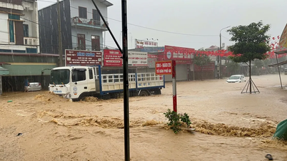
On land, the coastal areas of Quang Ninh and Hai Phong also have strong winds of level 6 and level 8. Heavy rain is forecast to occur during the day and night of August 19 in the Northeast and Thanh Hoa with common rainfall of 40-100mm, in some places very heavy rain over 250mm (reduced compared to the forecast on August 18).
Source: https://www.sggp.org.vn/ap-thap-nhiet-doi-di-vao-quang-ninh-hai-phong-post809047.html


Comment (0)