
 |
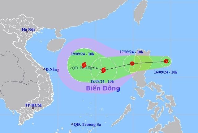
| Direction of the tropical depression. (Photo: Center for Hydro-meteorological Forecasting) |
That is what Mr. Nguyen Van Huong - Head of Weather Forecast Department, National Center for Hydro-Meteorological Forecasting shared with reporters about the tropical depression near the East Sea on the evening of September 16.
According to Mr. Huong, at 1:00 p.m. this afternoon (September 16), the center of the tropical depression was at about 17.1 degrees North latitude, 123.9 degrees East longitude in the sea east of Luzon Island (Philippines), with a strong tropical depression intensity of level 6. It is forecasted that in the next 24 hours, the tropical depression will move mainly in a westerly direction, at a speed of about 15-20km/h.
Mr. Huong also said that the location of this tropical depression is relatively similar to the location of storm No. 3 (Yagi), which is in the East of Luzon Island (Philippines). However, the current environmental conditions are not as favorable as storm No. 3, and this tropical depression has to share energy and moisture with another storm active in the Northwest Pacific . Therefore, when entering the East Sea, this tropical depression will not immediately strengthen into a storm, but will take 1-2 days to complete its structure and possibly develop into a storm.
In addition to interacting with the storm active in the Northwest Pacific , when entering the East Sea, the tropical depression is also affected by the large-scale guiding flow from the highly fluctuating subtropical high pressure.
“In addition, another unfavorable weather condition is that the cold air mass may affect our country after September 19. With all the current and future conditions, the path of the tropical depression and possibly storm No. 4 will be more complicated than storm Yagi,” said the Head of the Weather Forecast Department.
 |
Mr. Nguyen Van Huong - Head of Weather Forecast Department, National Center for Hydro-Meteorological Forecasting. (Photo: BL) |
According to Mr. Huong, the meteorological agency believes that around the morning of September 17, when entering the East Sea, the tropical depression will tend to gradually strengthen, but by September 18, the tropical depression will likely strengthen into a storm.
After that, when the storm moves to the central East Sea, the Hoang Sa archipelago area is likely to have two scenarios. The first scenario, when it strengthens into a storm, will move straight into the Central Central region. The second scenario is that after strengthening into a storm, it will change direction to move to the West Northwest, directly affecting the Northern and North Central regions. It is forecasted that if following this scenario, storm No. 4 will affect the mainland this weekend. "According to all forecast models of Vietnam and the world, the intensity of the tropical depression after strengthening into a storm cannot be as strong as storm Yagi," Mr. Huong emphasized.
At the same time, Mr. Huong also noted: In the immediate future, with the development of the tropical depression, after the high possibility of becoming storm No. 4, the meteorological agency issued some initial notes: strong winds, big waves at sea in the eastern area of the North East Sea, east of the 114th meridian, north of the 14th parallel.
It is forecasted that from the morning of September 17, the eastern sea of the North East Sea will have showers and thunderstorms, strong winds of level 7 to level 9, and rough seas. All vessels operating in this area are at risk. The impact on land needs to be monitored, because the storm will have many changes after entering the East Sea and when moving to the central area of the East Sea.
“If scenario two is followed, the storm’s impact will hit the mainland this weekend. If scenario one is followed, the storm’s impact may be 1 to 2 days earlier than scenario one when it enters the Central Central region,” Mr. Huong said./.


Comment (0)