
Updated to 5:00 p.m. on September 26 from the National Center for Hydro-Meteorological Forecasting, the center of storm Bualoi was at approximately 12.7 degrees North latitude - 120.2 degrees East longitude. The strongest wind near the center of the storm reached level 11 (103-117 km/h), gusting to level 14. The storm is moving in a West-Northwest direction at a speed of about 35 km/h, crossing the central Philippines. It is forecasted that tonight, September 26, the center of the storm will enter the East Sea and become storm number 10 in 2025.

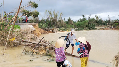
Director of the National Center for Hydro-Meteorological Forecasting Mai Van Khiem said that Bualoi is a storm with an unusually fast moving speed of about 30-35 km/h, nearly double the average. The storm is strong in intensity, has a wide range of influence, and is capable of causing many types of natural disasters at the same time, including strong winds, heavy rains, flash floods, landslides and coastal flooding.
It is forecasted that by 4 p.m. on September 27, the storm will continue to move in a West-Northwest direction at a speed of about 35 km/hour, with its center located in the Hoang Sa special zone. At this time, the storm will return to level 12, gusting to level 15.
By 4 p.m. on September 28, the storm continued to move west-northwest at a speed of 25-30 km/h and continued to strengthen. At this time, the storm center was located on the sea from Nghe An to Hue. Wind intensity will increase to level 13, gusting to level 16. The dangerous area extends from latitude 13.5 to 21 and from longitude 108 to 116.5. The storm caused natural disasters at level 3, affecting the northern region and the entire middle of the East Sea, Hoang Sa special zone, the sea area of Thanh Hoa - Quang Ngai, the islands of Hon Ngu, Con Co, Ly Son and the northern Gulf of Tonkin (including Bach Long Vy).
The National Center for Hydro-Meteorological Forecasting said that on September 29, the storm's center will move in a West-Northwest direction at a speed of 20-25km/hour, moving deep into the mainland of our country.
According to the Vietnam Meteorological Agency, tomorrow night, September 27, the sea area from Thanh Hoa to Quang Ngai , including Hon Ngu Island, Con Co Special Zone, and Ly Son will have strong winds of level 6-7, gusts of 8-9, and waves 3-5m high.
By early morning of September 28, the wind increased to level 8-9, near the storm center it reached level 10-13, gusts of 16, waves of 5-7m, and rough seas.
In the northern area of Bac Bo Gulf, including Bach Long Vy, Van Don, Co To, Cat Hai and Hon Dau, early morning on September 28, strong winds of level 6-7, then increased to level 8-9, gusts of 11, waves 3-5m high, very rough seas.
In addition to the danger to ships operating in the area, the storm will also cause heavy rain on land. From September 28 to 30, the North and provinces from Thanh Hoa to Quang Tri will have widespread heavy rain. The area from Hue to Quang Ngai will have moderate to heavy rain.
Source: https://www.sggp.org.vn/bao-bualoi-di-chuyen-nhanh-gap-doi-binh-thuong-post814915.html
![[Photo] General Secretary To Lam receives President of the Senate of the Czech Republic Milos Vystrcil](/_next/image?url=https%3A%2F%2Fvphoto.vietnam.vn%2Fthumb%2F1200x675%2Fvietnam%2Fresource%2FIMAGE%2F2025%2F11%2F21%2F1763723946294_ndo_br_1-8401-jpg.webp&w=3840&q=75)


![[Photo] Visit Hung Yen to admire the "wooden masterpiece" pagoda in the heart of the Northern Delta](/_next/image?url=https%3A%2F%2Fvphoto.vietnam.vn%2Fthumb%2F1200x675%2Fvietnam%2Fresource%2FIMAGE%2F2025%2F11%2F21%2F1763716446000_a1-bnd-8471-1769-jpg.webp&w=3840&q=75)
![[Photo] President Luong Cuong receives Speaker of the Korean National Assembly Woo Won Shik](/_next/image?url=https%3A%2F%2Fvphoto.vietnam.vn%2Fthumb%2F1200x675%2Fvietnam%2Fresource%2FIMAGE%2F2025%2F11%2F21%2F1763720046458_ndo_br_1-jpg.webp&w=3840&q=75)
![[Photo] National Assembly Chairman Tran Thanh Man holds talks with President of the Senate of the Czech Republic Milos Vystrcil](/_next/image?url=https%3A%2F%2Fvphoto.vietnam.vn%2Fthumb%2F1200x675%2Fvietnam%2Fresource%2FIMAGE%2F2025%2F11%2F21%2F1763715853195_ndo_br_bnd-6440-jpg.webp&w=3840&q=75)


Comment (0)