
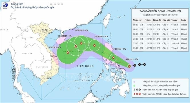
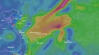
Accordingly, at 4 p.m., the center of the storm was at about 15.2 degrees North latitude; 119.7 degrees East longitude. The strongest wind near the center of the storm was level 9 (75-88 km/h), gusting to level 11. Moving northwest at a speed of 20-25 km/h.
Forecast by 4pm on October 20, the storm in the North East Sea area, about 380km East Northeast of Hoang Sa special zone, strong winds of level 10, gusts of level 12, moving northwest at a speed of about 20-25km/h and likely to strengthen. The affected area is the North East Sea area. Disaster risk level 3.
At 4:00 p.m. on October 21, the storm was in the North East Sea, about 200 km north of Hoang Sa special zone, with winds of level 11, gusts of level 13, moving west at a speed of about 10-15 km/h and likely to intensify. The affected area is the North East Sea (including Hoang Sa special zone). Disaster risk level 3.
At 4:00 p.m. on October 22, the storm was in the sea northwest of Hoang Sa special zone, about 220km northeast of Da Nang city, with strong winds of level 9, gusts of level 11, moving southwest at a speed of about 10-15km/h and likely to weaken. The affected area is the sea west of the North East Sea (including Hoang Sa special zone), the sea from Hue city to Quang Ngai. Natural disaster risk level 3.
From the next 72 to 120 hours, the storm will move mainly in the southwest direction, about 10km per hour and gradually weaken.
Due to the influence of the storm, the eastern sea area of the North East Sea has strong winds of level 6-7; the area near the storm's center has strong winds of level 8-10, gusts of level 12, waves 3-5m high, very rough seas.
Warning: During October 20-22, the North East Sea area (including Hoang Sa special zone) may be affected by strong winds of level 10-11, gusts of level 13, waves 5-7m high, and rough seas.
Source: https://baohaiphong.vn/bao-fengshen-di-vao-bien-dong-tro-thanh-con-bao-so-12-524046.html


Comment (0)