

At 7 PM on November 3rd, Typhoon Kalmaegi was located off the central coast of the Philippines with wind speeds of level 12-13 (118-149 km/h), gusting to level 16. It is predicted that around the morning of November 5th, Typhoon Kalmaegi will enter the South China Sea and become the 13th typhoon of 2025.
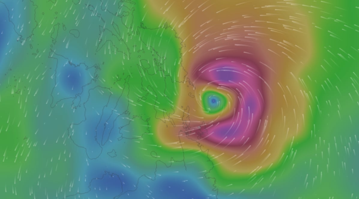
On the evening of November 3rd, Typhoon Kalmaegi was approaching the central Philippines with wind speeds of level 12-13, gusting to level 15. Photo: Vietnam Disaster Monitoring System.
According to the Department of Meteorology and Hydrology ( Ministry of Agriculture and Environment ), Typhoon Kalmaegi is moving rapidly and is very strong, so the agency anticipates issuing an emergency typhoon warning as soon as the typhoon enters the East Sea (morning of November 5th), meaning the typhoon has the potential to affect Vietnam within the next 48 hours.
From around the afternoon of November 4th, the eastern part of the central South China Sea experienced increasingly strong winds, reaching levels 6-7, then increasing to levels 8-10; near the storm's center, winds reached levels 11-13, with gusts up to levels 15-16. Wave heights reached 5-7 meters; the sea was extremely rough.
The storm is forecast to reach intensity levels 13-14 in the Truong Sa Special Zone and over the sea area between Da Nang and Khanh Hoa. Around November 5-6, the central East Sea (including the Truong Sa Special Zone) and the sea area off the coast of Da Nang - Khanh Hoa are likely to experience strong winds of levels 12-14, gusting above level 17. Wave heights will reach 8-10 meters, with extremely rough seas. All vessels and structures operating in the aforementioned dangerous zone will be severely affected by thunderstorms, tornadoes, strong winds, and high waves.
From around the night of November 6th, the storm is likely to directly affect the area from Da Nang to Khanh Hoa . The strongest winds in the coastal sea area (including Ly Son special zone) are likely to reach level 12-13, with gusts exceeding level 15. In the inland coastal area, winds are likely to reach level 10-12, with gusts of level 14-15.
"This is a very strong storm, and thunderstorms and tornadoes may occur before the storm," the forecasting agency emphasized.
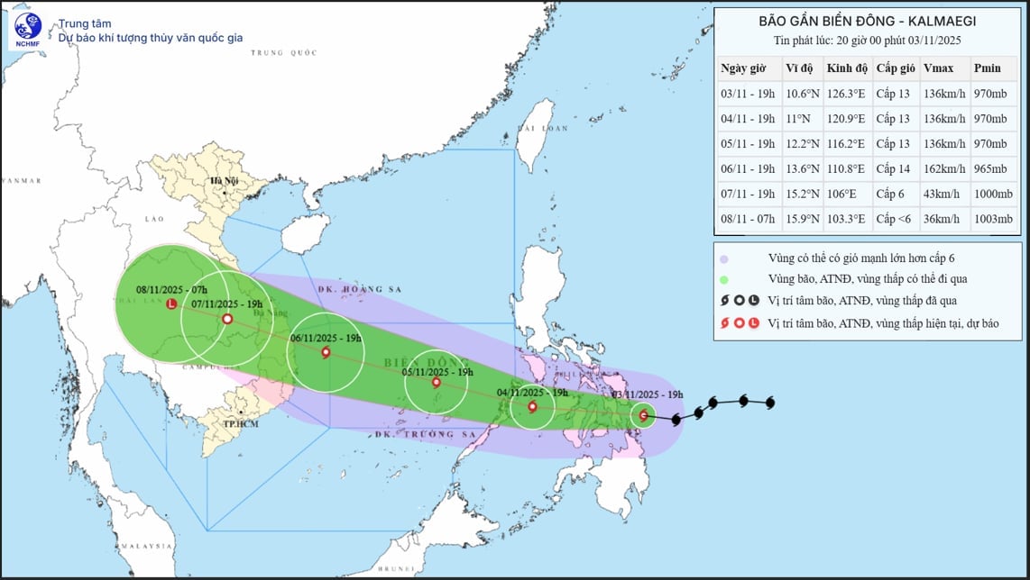
Forecast of the trajectory and intensity of Typhoon Kalmaegi in the 8 PM bulletin on November 3rd. Photo: NCHMF .
Widespread heavy rain is likely to begin from the night of November 6th to November 9th in the area from Quang Tri to Dak Lak. There is a risk of a new flood wave on rivers from Quang Tri province to Khanh Hoa province.
Since the storm is still far away, current observation and forecast data require further monitoring. Its trajectory, intensity, direction of movement, rain center, and rainfall amount are likely to fluctuate in the coming days. Therefore, the Department of Meteorology and Hydrology requests that ministries, sectors, and localities continue to closely monitor forecast and warning bulletins to proactively respond.
Natural disasters are expected to strike in the next 10 days.
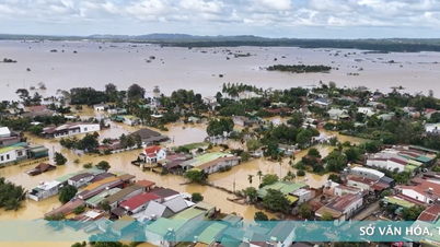
Currently, the central provinces are facing rising water levels on rivers, with widespread flooding occurring in many localities. Based on monitoring and analysis of the current weather system and forecast products, the Department of Meteorology and Hydrology predicts that in the next 10 days (November 3-13), several dangerous natural disasters will continue to occur in the region.
Due to the influence of continuously strengthening cold air, combined with several factors (tropical convergence zone, low-pressure area in the southern East Sea, upper-level easterly wind disturbance), from the afternoon of November 3rd to the end of November 4th, the area from Ha Tinh province to Hue city will continue to experience heavy to very heavy rain with rainfall amounts generally ranging from 150-250 mm, and locally exceeding 400 mm.
Rainfall is forecast to decrease from the afternoon of November 4th to November 6th . However, flood levels remain high and flooding persists. By the end of November 4th, flood levels on the Bo River, Huong River (Hue City), and Vu Gia - Thu Bon River (Da Nang City) fluctuated at high levels, then gradually receded, fluctuating at or above Flood Level 2. Flood levels on the Kien Giang River (Quang Tri Province) fluctuated above Flood Level 3. On the Thach Han River (Quang Tri Province), there is a possibility of floodwaters reaching Flood Levels 2-3.
Due to the influence of Typhoon No. 13, heavy rain returned to a wide area from the night of November 6th, causing floods to rise again on the rivers. The soil is already saturated, and combined with the heavy rain forecast for the coming days, this will greatly increase the risk of flash floods and landslides in mountainous areas from Ha Tinh to Gia Lai, with the focus on the provinces/cities of Ha Tinh, Quang Tri, Hue, Da Nang, Quang Ngai, and Gia Lai.
In addition to the regularly issued weather forecasts and disaster warnings, to monitor real-time information on thunderstorms, tornadoes, lightning, flash floods, and landslides, the Department of Meteorology and Hydrology requests that agencies access the Department's warning systems at the following addresses: http://iweather.gov.vn/ and http://luquetsatlo.nchmf.gov.vn/ for updates. Ministries and provincial People's Committees are directed to instruct specialized agencies to direct reservoir management and operation units to closely monitor meteorological and hydrological developments, implement observation and forecasting regimes, and provide information, data, and reports as prescribed to the Department of Meteorology and Hydrology. This data source is crucial for forecasting and warning, ensuring accurate and effective response measures and guaranteeing the safety of people's lives.
Source: https://nongnghiepmoitruong.vn/bao-kalmaegi-manh-cap-bao-nhieu-khi-do-bo-d782113.html
![[Photo] General Secretary and President To Lam presides over the meeting to approve the draft report on the results of the second inspection by the Politburo of the Standing Committee of the Hanoi City Party Committee.](https://vphoto.vietnam.vn/thumb/1200x675/vietnam/resource/IMAGE/2026/05/26/1779789811432_a2-bnd-4430-9620-jpg.webp)


































































































Comment (0)