
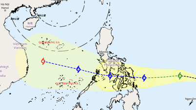
According to the National Center for Hydro-Meteorological Forecasting, at 7:00 a.m. on October 5, the center of storm Koinu was at about 22 degrees north latitude; 120.8 degrees east longitude, in the sea south of Taiwan (China). The storm is at level 14 (150 - 166 km/h), gusting to level 17, moving westward at 10 km per hour.

Map of the path of typhoon Koinu
NATIONAL CENTER FOR HYDRO-METEOROLOGICAL FORECASTING
Speaking to reporters, Mr. Nguyen Van Huong, Head of Weather Forecasting Department, National Center for Hydro-Meteorological Forecasting, said that at around 1:00 p.m. this afternoon (October 5), storm Koinu will approach the southeast of Taiwan island at level 14 - 15. On the afternoon of October 6, this storm will cross the 120th parallel, enter the East Sea and become storm number 4 in 2023.
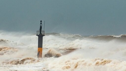
"When entering the East Sea, the storm will weaken by about 2 levels. At present, we believe that the storm will weaken and dissipate at sea. The impact of this storm on Vietnam will mainly be at sea with a level 6-7 intensity, the area near the storm's center will be at level 9 and may increase to level 10, level 11. From October 6 to 8, in the northern area of the North East Sea, waves will be 6-8 meters high," Mr. Huong said, adding that the storm is unlikely to affect the mainland.
When moving to the west of Guangdong province (China), Storm Koinu will weaken and is less likely to enter the Gulf of Tonkin, so the possibility of impact on coastal areas of Vietnam is low.
"We believe that storm Koinu will not affect the mainland, so it is unlikely to cause rain. However, in the coming time, cold air will flow to the North, causing thunderstorms, tornadoes, and strong lightning," Mr. Huong added.
According to the meteorological agency, due to the influence of storm Koinu, the northeastern sea area of the northern East Sea will have winds gradually increasing to level 7 - 10, from the afternoon of October 5, the area near the storm's center will have strong winds of level 11 - 12, gusting to level 15; the sea will be very rough.
In the northern East Sea, waves are 2 - 4 m high, in the northeastern region, waves are 4 - 6 m high, and near the storm center, waves are 6 - 8 m high.
Source link
![[Photo] Lam Dong: Images of damage after a suspected lake burst in Tuy Phong](https://vphoto.vietnam.vn/thumb/1200x675/vietnam/resource/IMAGE/2025/11/02/1762078736805_8e7f5424f473782d2162-5118-jpg.webp)


![[Photo] Prime Minister Pham Minh Chinh chairs the second meeting of the Steering Committee on private economic development.](https://vphoto.vietnam.vn/thumb/1200x675/vietnam/resource/IMAGE/2025/11/01/1762006716873_dsc-9145-jpg.webp)


Comment (0)