
Storm Koto is forecast to maintain its maximum intensity of level 12 until the afternoon of November 28, after which its intensity may gradually decrease due to the influence of cold air.
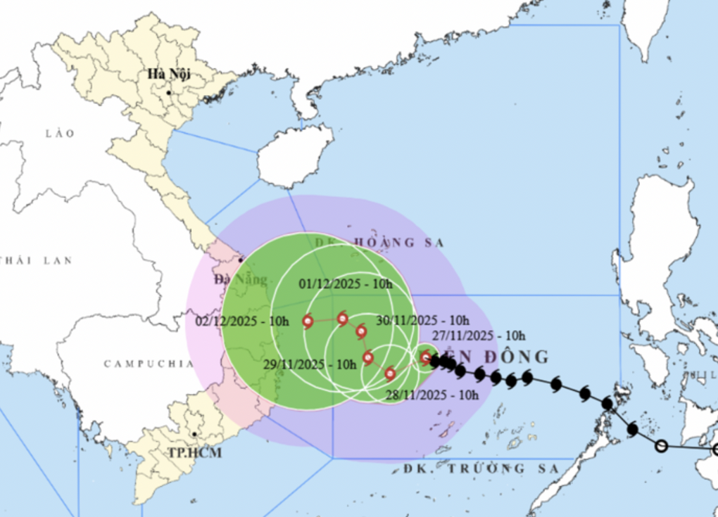 |
| The movement of storm Koto (Photo: NCHMF). |
The National Center for Hydro-Meteorological Forecasting said that on the afternoon of November 27, storm No. 15 (international name Koto) was in the western sea area of the central East Sea with intensity of level 12, gusting to level 15 (118-133km/h).
In the next 24 hours, the storm will move mainly in the West-Southwest direction at a speed of 5-10km/h. Compared to the early morning of the same day, storm Koto has changed its direction from West-Northwest to West-Southwest.
By the afternoon of November 28, the storm in the western sea area of the central East Sea, about 200km northwest of Song Tu Tay Island, with a level 12 intensity, gusting to level 15, is likely to weaken.
The following afternoon (November 29), storm Koto was in the western sea area of the central East Sea with a level 11 intensity, gusting to level 14.
From the next 72 to 120 hours, the storm will move slowly to the Northwest, then likely change direction to the West, speed 3-5km/h and intensity will continue to weaken.
Due to the influence of storm Koto, the central East Sea area (including the sea area north of Truong Sa special zone) has strong winds of level 7-9; the area near the storm's eye has strong winds of level 10-12, gusting to level 15; waves 4-6m high, the area near the storm's eye 7-9m; the sea is very rough.
The hydrometeorological agency warns that ships operating in the above-mentioned dangerous areas are likely to be affected by storms, whirlwinds, strong winds, and large waves.
The Japan Meteorological Agency forecasts that typhoon Koto is at its strongest stage with winds of about 144km/h (level 13) and will maintain this level until the evening of November 28 and then move slowly and gradually weaken.
This station forecasts that by the afternoon of November 30, the strongest wind near the storm's center will be about 90km/h (level 10).
Hong Kong Radio forecasts the storm is reaching its peak speed of 120km/h, and as it moves north it is likely to gradually lose intensity.
According to Mr. Hoang Phuc Lam, Deputy Director of the National Center for Hydro-Meteorological Forecasting, when storm Koto enters the 112-113 meridian, it tends to deviate to the north.
As the storm moves north and nears the shore, it encounters colder sea surface temperatures, and cold air intensifies and penetrates deep into the storm's circulation, weakening it.
To be ready to respond to storm No. 15, the army mobilized more than 267,000 officers and soldiers along with nearly 6,700 vehicles of all kinds, including 6 helicopters, ready to respond.
According to dantri.com.vn
Source: https://baovinhlong.com.vn/thoi-su/202511/bao-koto-suy-yeu-dan-khi-gap-khong-khi-lanh-chieu-2811-5d72e47/


![[Photo] Prime Minister Pham Minh Chinh chairs the 15th meeting of the Central Emulation and Reward Council](/_next/image?url=https%3A%2F%2Fvphoto.vietnam.vn%2Fthumb%2F1200x675%2Fvietnam%2Fresource%2FIMAGE%2F2025%2F11%2F27%2F1764245150205_dsc-1922-jpg.webp&w=3840&q=75)
![[Photo] President Luong Cuong attends the 50th Anniversary of Laos National Day](/_next/image?url=https%3A%2F%2Fvphoto.vietnam.vn%2Fthumb%2F1200x675%2Fvietnam%2Fresource%2FIMAGE%2F2025%2F11%2F27%2F1764225638930_ndo_br_1-jpg.webp&w=3840&q=75)


Comment (0)