
At 4:00 a.m. on July 22, the center of the storm was located at about 20.5 degrees North latitude; 107.2 degrees East longitude, about 140km from Quang Ninh, 70km from Hai Phong , 80km from Hung Yen and 100km from Ninh Binh. The strongest wind near the center of the storm was level 9 - 10 (75 - 102km/hour), gusting to level 13. The storm is moving in a West Southwest direction at a speed of 15km/hour.
According to the National Center for Hydro-Meteorological Forecasting, by 4 p.m. on July 22, the area directly affected from Hai Phong to Thanh Hoa will have strong winds of level 8, gusting to level 10. It is expected that by the early morning of July 23, the storm will move deep inland and weaken into a low pressure area over the Vietnam - Laos border area.
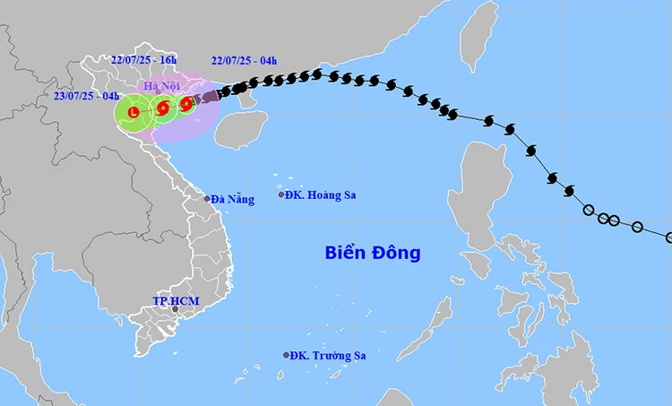
The path and position of storm No. 3 at 5:00 a.m. on July 22. Photo: thoitietvietnam
At sea, the Northern Gulf of Tonkin recorded strong winds of level 7-8, near the storm center level 9-10, gusting to level 13; waves 3-5m high, rough seas. The Southern Gulf of Tonkin had winds of level 6-7, near the storm center level 8, gusting to level 11; waves from 2-4m.
On land, provinces from Quang Ninh to Nghe An will have strong winds of level 7-8, near the storm center level 9-10, gusting to level 13. Inland areas such as Hai Phong, Hung Yen, Bac Ninh, Hanoi , Ninh Binh and Thanh Hoa are forecast to have strong winds of level 6, gusting to level 7-8.
The meteorological agency warned that strong winds could cause trees and electric poles to fall and roofs to be blown off, especially in coastal areas and densely populated urban areas.
Storm surge is expected to reach 0.5 - 1m in coastal areas from Hung Yen to Quang Ninh. Water levels at coastal stations are recorded to increase: Hon Dau 3.9 - 4.1m, Cua Ong 4.6 - 5m, Tra Co 3.6 - 4m, Ba Lat 2.4 - 5m.
There is a high risk of flooding in estuaries and coastal areas at noon and in the afternoon of July 22, especially in low-lying urban areas such as Ha Long, Hai Phong, Nam Dinh and Ninh Binh.
From early morning of July 22 to July 23, the provinces of the Northern Delta, Thanh Hoa and Nghe An will have very heavy rain with total rainfall of 200 - 300mm, locally exceeding 500mm. The mountainous provinces of the North and Ha Tinh will have rain from 70 - 150mm, some places may exceed 250mm.
The National Steering Committee for Natural Disaster Prevention and Control requested localities from Quang Ninh to Nghe An to complete securing houses, reinforcing rafts, boats, and evacuating people from dangerous areas on July 22.
All tourist boats, fishing and aquaculture vessels in the Gulf of Tonkin have been asked to temporarily suspend operations. Mountainous areas are advised to closely monitor landslides and flash floods caused by heavy rain.
Special warning for areas with extremely heavy rain of over 150mm within 3 hours, which can cause deep flooding, seriously affecting people's lives and property.
Weather forecast for regions across the country:
Hanoi capital is cloudy, with heavy to very heavy rain. Winds gradually increase to level 6, gusting to level 7 - 8. Lowest temperature 24 - 26 degrees Celsius. Highest temperature 27 - 29 degrees Celsius.
The Northwest region is cloudy with moderate rain, heavy rain and thunderstorms, locally very heavy rain. West to northwest wind level 2 - 3. During thunderstorms, there is a possibility of tornadoes, lightning and strong gusts of wind. The lowest temperature is 23 - 26 degrees Celsius, some places below 22 degrees Celsius. The highest temperature is 27 - 30 degrees Celsius, some places above 30 degrees Celsius.
The northeastern provinces are cloudy with moderate to heavy rain, especially in the plains with heavy to very heavy rain. In the provinces/cities of Hai Phong, Hung Yen, Ninh Binh, the wind is strong at level 6, gusting at level 7 - 8, especially in the coastal areas from Quang Ninh to Ninh Binh, the wind gradually increases to level 7 - 8, near the storm center it increases to level 9 - 10, gusting at level 13. Other places have winds gradually increase to level 3 - 4. The lowest temperature is 23 - 26 degrees Celsius, some places below 22 degrees Celsius. The highest temperature is 27 - 30 degrees Celsius, especially in the mountainous areas, some places are above 30 degrees Celsius.
Provinces from Thanh Hoa to Hue are cloudy, with moderate rain, heavy rain and thunderstorms in the North, especially Thanh Hoa - Nghe An with heavy to very heavy rain; scattered showers and thunderstorms in the South. Coastal areas of Thanh Hoa - Nghe An have winds gradually increasing to level 7 - 8, areas near the storm center have winds of level 9 - 10, gusting to level 13; areas deep inland of Thanh Hoa have strong winds of level 6, gusting to level 7 - 8. In other places, southwest winds of level 3 - 4. During thunderstorms, there is a possibility of tornadoes, lightning and strong gusts. Lowest temperature 24 - 27 degrees Celsius. Highest temperature 26 - 29 degrees Celsius, some places in the South are over 30 degrees Celsius.
The South Central Coast region is cloudy with scattered showers and thunderstorms. Southwesterly winds level 3-4. Thunderstorms are likely to produce tornadoes, lightning, hail and strong gusts of wind. Lowest temperature 26-29 degrees Celsius. Highest temperature 31-34 degrees Celsius.
The Central Highlands is cloudy with scattered showers and thunderstorms, with scattered showers and thunderstorms in the afternoon and evening, with some heavy rain in some places. Southwesterly winds level 3-4. There is a possibility of tornadoes, lightning and strong gusts of wind during thunderstorms. The lowest temperature is 20-23 degrees Celsius. The highest temperature is 25-28 degrees Celsius, with some places above 28 degrees Celsius.
The South is cloudy with scattered showers and thunderstorms, with scattered showers and thunderstorms in the afternoon and evening, with some heavy rain in some places. Southwesterly wind level 3. There is a possibility of tornadoes, lightning and strong gusts of wind during thunderstorms. Lowest temperature 23 - 26 degrees Celsius. Highest temperature 30 - 33 degrees Celsius, with some places above 33 degrees Celsius.
Ho Chi Minh City is cloudy with scattered showers and thunderstorms, with scattered showers and thunderstorms in the afternoon and evening, with some heavy rain in some places. Southwesterly wind level 3. There is a possibility of tornadoes, lightning and strong gusts of wind during thunderstorms. Lowest temperature 23 - 26 degrees Celsius. Highest temperature 31 - 33 degrees Celsius.
According to Tin Tuc and Dan Toc Newspaper
Source: https://baoquangtri.vn/bao-so-3-gay-bien-dong-du-doi-bac-bo-mua-lon-va-ngap-lut-196070.htm


Comment (0)