
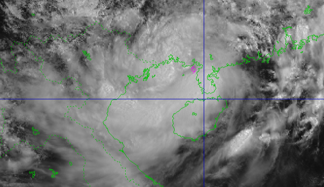
Satellite image of storm No. 3 at 10:00 a.m. on July 21 - Photo: NCHMF
According to the National Center for Hydro-Meteorological Forecasting, at 9:00 a.m. this morning (July 21), storm No. 3 passed the Leizhou peninsula (China) and entered the Gulf of Tonkin.
The storm center is currently about 190km from Quang Ninh, 310km from Hai Phong , 340km from Hung Yen and 365km from Ninh Binh to the east-northeast, with a storm intensity of level 9 (74-88km/h), gusting to level 11.
After entering the Gulf of Tonkin, storm No. 3's winds may strengthen again by 1-2 levels (up to level 10-11).
Level 10-11 storm winds can knock down trees, electric poles, and rip off roofs.
From the evening and night of July 21, coastal areas from Quang Ninh to Nghe An will have winds gradually increasing to level 7-9, areas near the storm center will have winds of level 10-11, gusting to level 14, and areas deep inland in the provinces and cities of Hai Phong, Hung Yen , Ninh Binh and Thanh Hoa will have strong winds of level 6, gusting to level 7-8.
It is forecasted that tomorrow (July 22), the storm will approach the shore and make landfall in the provinces and cities from south Hai Phong to north Thanh Hoa , so people in these localities need to proactively take response measures before the storm makes landfall.
According to the meteorological agency, if the storm winds are strong enough to reach level 8 (62-74km/h), with gusts of wind possibly exceeding level 10, tree branches can easily break, and some large trees can be uprooted. Pedestrians will find it almost impossible to move, and strong winds will clearly impact infrastructure.
Strong storm winds of level 9 (75-88km/h), gusts of wind over level 11 can cause large trees to fall. Many weak structures can be damaged, roofs can be blown off, causing damage to weak roofs. Road traffic is severely hindered, signs and outdoor structures can easily be damaged or collapsed. The sea is very rough, dangerous for ships and boats operating at sea.
Strong storm winds of level 10 (89-102km/h), gusts of wind over level 12 can destroy large trees, many weak and unstable constructions can be seriously damaged. Very dangerous for ships at sea and cause damage to piers and docks where ships take shelter from storms.
Strong storm winds of level 11 (103-117km/h), gusts of up to level 13 can cause serious damage to fragile structures. Very dangerous for boats and coastal residents. Infrastructure such as roofs and windows can be severely damaged.

Soldiers at the Hon Gai Port Border Guard Station encourage fishermen to bring their boats to shelters - Photo: VIET ANH
Do not go out when storm number 3 is making landfall.
The Department of Dyke Management and Natural Disaster Prevention (Ministry of Agriculture and Environment) recommends that people in localities monitor forecasts, warnings, and updates on storm developments to proactively prevent and avoid them.
For ships, it is necessary to enter places with ports and waterways. In case there are no ports, they can enter sheltered river channels to anchor.
Absolutely do not stay on anchored boats, tourist boats, watchtowers, rafts, or aquaculture areas when a storm hits.
On land, it is necessary to reinforce and brace houses, prune tree branches, remove potentially unsafe billboards and posters, and ensure the safety of construction sites.
Absolutely do not go out when the storm is making landfall, except in emergency cases and with specific instructions from authorities.
People identify the safest shelter for all family members and proactively evacuate when necessary or as requested by local authorities. Proactively stock up on food, drinking water, medicine, and necessary supplies.
To prevent rain, floods, and inundation in low-lying areas and urban areas, people need to raise their assets, keep important documents in safe places, and move their vehicles to higher terrain.
Also save emergency phone numbers for use in case of emergency.
Tuoitre.vn
Source: https://tuoitre.vn/bao-so-3-nguy-hiem-the-nao-neu-do-bo-voi-gio-manh-cap-10-11-20250721114418458.htm

![[Photo] Panorama of the Patriotic Emulation Congress of Nhan Dan Newspaper for the period 2025-2030](https://vphoto.vietnam.vn/thumb/1200x675/vietnam/resource/IMAGE/2025/11/04/1762252775462_ndo_br_dhthiduayeuncbaond-6125-jpg.webp)

![[Photo] Opening of the 14th Conference of the 13th Party Central Committee](https://vphoto.vietnam.vn/thumb/1200x675/vietnam/resource/IMAGE/2025/11/05/1762310995216_a5-bnd-5742-5255-jpg.webp)


Comment (0)