
 |
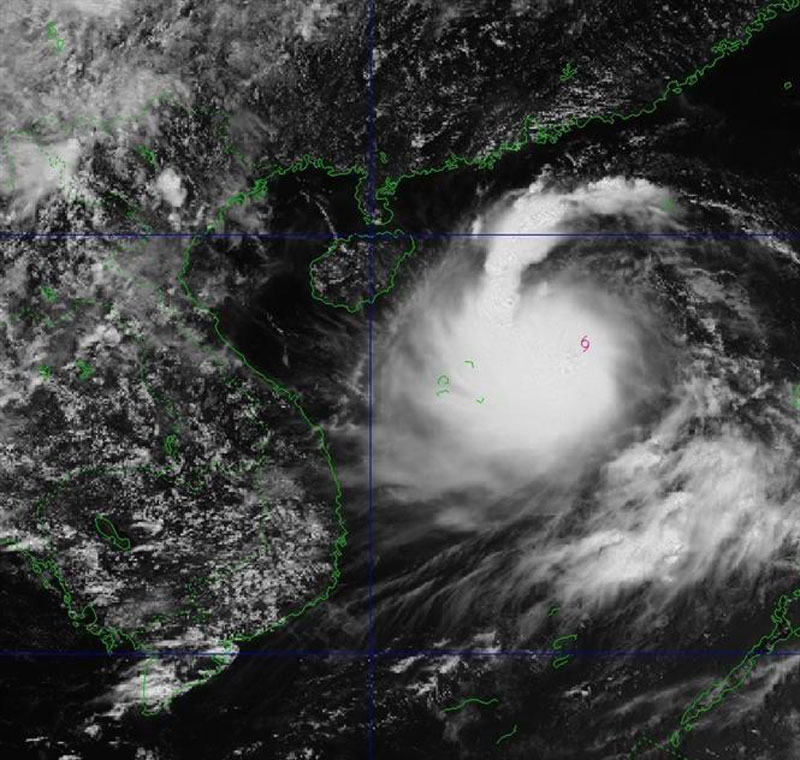
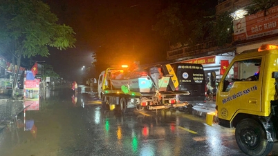
| The movement of storm No. 5 from Vietnam's natural disaster monitoring system, at 1 p.m. on August 23. Photo: VNA |
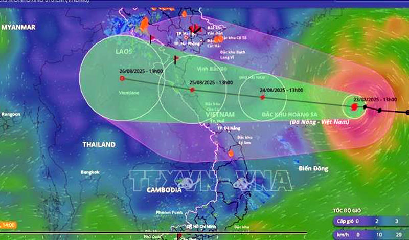
The storm is moving in the West Northwest direction at a speed of about 20-25km/h.
Commenting specifically on the storm's developments, Dr. Hoang Phuc Lam, Deputy Director of the National Center for Hydro-Meteorological Forecasting, said that as of 1 p.m. on August 24, the storm was in the sea south of Hainan Island (China) with strong winds of level 11-12, gusting to level 14; moving in the West-Northwest direction at a speed of about 20-25 km/h and continuing to strengthen. The affected area is the North East Sea (including Hoang Sa special zone), the offshore sea from Quang Tri - Hue. The natural disaster risk level is level 3.
By 1 p.m. on August 25, the storm was in the coastal waters from Thanh Hoa to Quang Tri with strong winds of level 12, gusts of level 15; moving in the West Northwest direction at a speed of about 15 - 20 km/h. The affected areas are the West of the North East Sea (including Hoang Sa special zone) with a disaster risk level of level 3; the Gulf of Tonkin, the Gulf of Tonkin, the sea area south of Quang Tri - Hue. Disaster risk level of level 4.
 |
| The center of storm No. 5 at 1 p.m. on August 23. Photo: VNA |
At 1 p.m. on August 26, the storm was on land in the Central Laos region with strong winds of level 6, gusts of level 8; moving in the West Northwest direction at a speed of about 15 km/h and gradually weakening into a tropical depression. The affected area is the Gulf of Tonkin, south of Quang Tri - Hue. Disaster risk level 3.
Due to the influence of the storm, the North East Sea area (including Hoang Sa special zone) has strong winds of level 8 - 9, the area near the storm's eye has winds of level 10 - 11, gusts of level 14, waves 4 - 6m high, and rough seas.
From noon and afternoon of August 24, the sea area from Thanh Hoa to Hue (including Con Co and Hon Ngu special zones) will have winds gradually increasing to level 6 - 8, then increasing to level 9 - 10, the area near the storm's center will have winds of level 11 - 13, gusts of level 15, waves 4 - 6m high, the area near the center will have waves of 6 - 8m, and the sea will be very rough.
From the afternoon of August 24, the sea area in the northern Gulf of Tonkin (including Bach Long Vi special zone) has gradually increased winds to level 6 - 7, gusts to level 9, waves 2 - 4m high, and rough seas.
Coastal areas from Ninh Binh to Northern Quang Tri have storm surges of 0.5 - 1.2m. Water levels in Sam Son (Thanh Hoa) are 3.2 - 3.6m high, in Hon Ngu (Nghe An) are 3.3 - 3.8m high, in Vung Ang (Ha Tinh) are 2.2 - 2.8m high and in Cua Gianh (Quang Tri) are 1.5 - 2m high. There is a high risk of flooding in low-lying coastal areas, river mouths, and islands from Nghe An to Northern Quang Tri.
Deputy Director Hoang Phuc Lam warned: The weather at sea and in coastal areas during the storm is extremely dangerous, unsafe for any vehicle or structure operating in the danger zone such as: tourist boats, passenger ships, transport ships, cages, rafts, aquaculture areas, dykes, embankments, coastal routes. Vehicles are highly likely to capsize, be destroyed; be flooded due to strong winds, big waves and rising sea levels.
On land: From the night of August 24, on land from Thanh Hoa to Quang Tri, winds will gradually increase to level 7 - 9, near the storm center level 10 - 12, gusting to level 14 - 15.
From the night of August 24 to the end of August 26, the Northern Delta, South Phu Tho and from Thanh Hoa to Hue are likely to experience widespread heavy rain with rainfall ranging from 100 - 150mm, locally over 250mm; the Thanh Hoa to Quang Tri area will experience heavy to very heavy rain with rainfall ranging from 150 - 300mm, locally over 600mm. Warning of the risk of heavy rain over 200mm in 3 hours.
From August 25 to August 26: Hanoi Capital and Da Nang City will have moderate rain, heavy rain and thunderstorms; Ho Chi Minh City will have rain, showers and thunderstorms in the late afternoon and evening. During thunderstorms, be on guard against the risk of tornadoes and strong gusts of wind.
From August 25 to 27, the Upper and Central Laos regions are likely to experience heavy rain with common rainfall of 100 - 250mm, and in some places in the Central Laos region, over 500mm.
Beware of flash floods and landslides in 4 northern provinces
The National Center for Hydro-Meteorological Forecasting said that from 2:40 p.m. to 7:40 p.m. on August 23, the provinces of Lai Chau, Dien Bien, Son La and Phu Tho will continue to have rain with accumulated rainfall ranging from 5-20 mm, in some places over 60 mm.
Warning of the risk of flash floods on small rivers and streams, landslides on steep slopes in many communes and wards: Le Loi, Nam Hang, Tua Sin Chai (Lai Chau province); Bung Lao, Chieng Sinh, Muong Ang, Muong Lan, Muong Phang, Muong Pon, Na Son, Na Tau, Dien Bien Phu, Muong Lay, Phinh Giang, Pu Nhi, Quai To, Sin Chai, Sinh Phinh, Thanh Nua, Thanh Yen, Tua Thang, Xa Dung (Dien Bien province); Bo Sinh, Co Ma, Long He, Muong Bam, Muong E, Nam Lau, Nam Ty, Thuan Chau (Son La province); Binh Tuyen, Lai Dong, Minh Dai, Xuan Hoa, Tam Dao, Tan Son, Thu Cuc, Vo Mieu (Phu Tho province).
Level of natural disaster risk due to flash floods, landslides, land subsidence due to heavy rain or level 1 flow.
Flash floods and landslides can have very negative impacts on the environment, threaten people's lives; cause local traffic congestion, affect the movement of vehicles; destroy civil and economic works, causing damage to production and socio-economic activities.
The Hydrometeorological Agency recommends that local authorities pay attention to reviewing bottlenecks and vulnerable locations in the area to have prevention and response measures.
Source: https://baothainguyen.vn/tai-nguyen-moi-truong/202508/bao-so-5-manh-cap-9-giat-cap-11-cach-dac-khu-hoang-sa-khoang-300km-5f20a4c/
![[Photo] Impressions of the Can Gio Whale Festival](https://vphoto.vietnam.vn/thumb/1200x675/vietnam/resource/IMAGE/2025/10/09/1759984089762_image12334-5642-jpg.webp)


![[Photo] Prime Minister Pham Minh Chinh chairs the Conference to deploy the National Target Program on Drug Prevention and Control until 2030](https://vphoto.vietnam.vn/thumb/1200x675/vietnam/resource/IMAGE/2025/10/09/1759990393779_dsc-0495-jpg.webp)


Comment (0)