
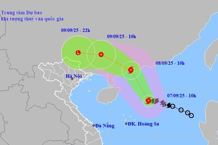
On the morning of September 7, storm No. 7 was located in the northern waters of the North East Sea. The strongest wind near the storm's center reached level 8-9, equivalent to 88 km/h, with gusts of level 11. The storm is moving in a West Northwest direction at a speed of about 10 km/h.
It is forecast that by 4 a.m. on September 8, the eye of the storm will be located in the sea south of Guangdong province, China. At this time, the wind speed may increase to level 10, gusting to level 13, before the storm makes landfall in this country and gradually weakens.
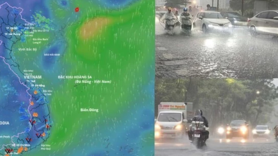
Heavy rain forecast for northern provinces
After making landfall in China, Storm No. 7 is forecast to rapidly weaken into a low-pressure area. This low-pressure area is then likely to move westward towards Vietnam.
From the evening of September 9 to the end of September 11, the post-storm circulation is expected to cause widespread heavy rain in the Northern region. The most directly affected provinces include Quang Ninh, Lang Son, Cao Bang , Thai Nguyen, Tuyen Quang and Lao Cai. Some places in the midland and mountainous areas of the Northeast are likely to experience very heavy rain.
The meteorological agency warns that in the coming days, thunderstorms may produce dangerous weather phenomena such as tornadoes, lightning, hail and strong gusts of wind.
People in affected areas need to regularly update forecast bulletins to proactively take preventive measures to ensure safety.
Source: https://baonghean.vn/bao-so-7-huong-vao-trung-quoc-6-tinh-mien-bac-viet-nam-sap-don-mua-lon-dien-rong-10306001.html


![[Photo] Highways passing through Dong Nai](https://vphoto.vietnam.vn/thumb/1200x675/vietnam/resource/IMAGE/2025/11/12/1762940149627_ndo_br_1-resize-5756-jpg.webp)


![Dong Nai OCOP transition: [Article 3] Linking tourism with OCOP product consumption](https://vphoto.vietnam.vn/thumb/402x226/vietnam/resource/IMAGE/2025/11/10/1762739199309_1324-2740-7_n-162543_981.jpeg)


Comment (0)