
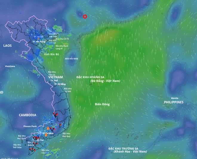
Updated position of tropical depression weakened from storm No. 7. Source: Vietnam Disaster Monitoring System
According to the National Center for Hydro-Meteorological Forecasting, tonight (September 8), after moving deep into the mainland of the southwestern region of Guangdong province (China), storm No. 7 weakened into a tropical depression.
At 7:00 p.m. on September 8 , the center of the tropical depression was at about 23.3 degrees north latitude; 111 degrees east longitude, on the mainland southwest of Guangdong province (China). The strongest wind near the center of the tropical depression was level 7 (50-61 km/h), gusting to level 9. The tropical depression moved northwest at a speed of 15-20 km/h.
Forecast in the next 12 hours , the tropical depression will move west-northwest at a speed of about 20km/hour, continuing to weaken into a low pressure area.
At 7:00 a.m. on September 9, the center of the low pressure area is forecast to be at about 23.9 degrees north latitude; 108.8 degrees east longitude, on the mainland of Guangxi province (China). Intensity below level 6.
The danger zone in the next 12 hours is north of 20.5 degrees north latitude and from 110.5 to 113.5 degrees east longitude. The natural disaster risk level is level 3, affecting the northwest sea area of the northern East Sea.
Forecast of the impact of the tropical depression on the sea , the northwest sea area of the northern East Sea has strong winds of level 6, gusts of level 8; waves 2 - 3.5m high, rough seas. Ships operating in the above-mentioned dangerous areas are likely to be affected by storms, whirlwinds, strong winds and big waves.
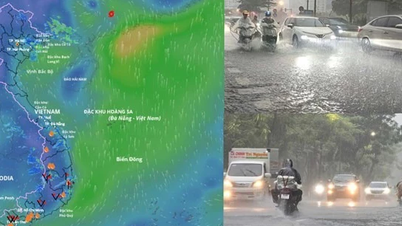
The meteorological agency noted that although not directly affected by the tropical low pressure circulation, areas on the far edge of the tropical low pressure circulation such as the Gulf of Tonkin, the Northern region and the eastern coastal areas of the North may experience thunderstorms, whirlwinds and strong gusts of wind.
From the afternoon of September 9 to the end of September 10 , the mountainous and midland areas of the North will have moderate rain, heavy rain and scattered thunderstorms, locally very heavy rain with common rainfall of 50-120mm, locally over 250mm. Warning of the risk of heavy rain with rainfall greater than 100mm within 3 hours.
On the night of September 10, the mountainous and midland areas of the North will have moderate to heavy rain and scattered thunderstorms, with some places experiencing very heavy rain with common rainfall of 20-40mm, and some places experiencing over 100mm.
Total rainfall from the afternoon of September 9 to the end of the night of September 10, in the mountainous and midland areas of the North, is generally 70 - 150mm, locally over 300mm.
Thunderstorms are likely to produce tornadoes, lightning, hail, and strong gusts of wind. The meteorological agency has warned that the risk of natural disasters caused by heavy rain, tornadoes, lightning, and hail is level 1.
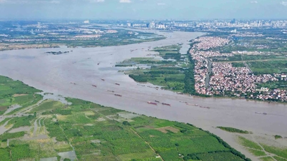
Heavy rain can cause flooding in low-lying areas, urban and industrial areas; flash floods in small rivers and streams; and landslides on steep slopes.
Real-time warning information on areas at risk of flash floods and landslides is provided online on the website of the Department of Hydrometeorology at: https://luquetsatlo.nchmf.gov.vn and in separate bulletins warning of flash floods and landslides.
Laodong.vn
Source: https://laodong.vn/moi-truong/bao-so-7-tapah-suy-yeu-thanh-ap-thap-nhiet-doi-sap-gay-mua-dong-gio-manh-1571144.ldo


![[Photo] Explore the US Navy's USS Robert Smalls warship](/_next/image?url=https%3A%2F%2Fvphoto.vietnam.vn%2Fthumb%2F1200x675%2Fvietnam%2Fresource%2FIMAGE%2F2025%2F12%2F10%2F1765341533272_11212121-8303-jpg.webp&w=3840&q=75)

![[Photo] The captivating scenery of the fragrant maple forest in Quang Tri](/_next/image?url=https%3A%2F%2Fvphoto.vietnam.vn%2Fthumb%2F1200x675%2Fvietnam%2Fresource%2FIMAGE%2F2025%2F12%2F10%2F1765353233198_lan09046-jpg.webp&w=3840&q=75)


![[Video] The craft of making Dong Ho folk paintings has been inscribed by UNESCO on the List of Crafts in Need of Urgent Safeguarding.](https://vphoto.vietnam.vn/thumb/402x226/vietnam/resource/IMAGE/2025/12/10/1765350246533_tranh-dong-ho-734-jpg.webp)


Comment (0)