
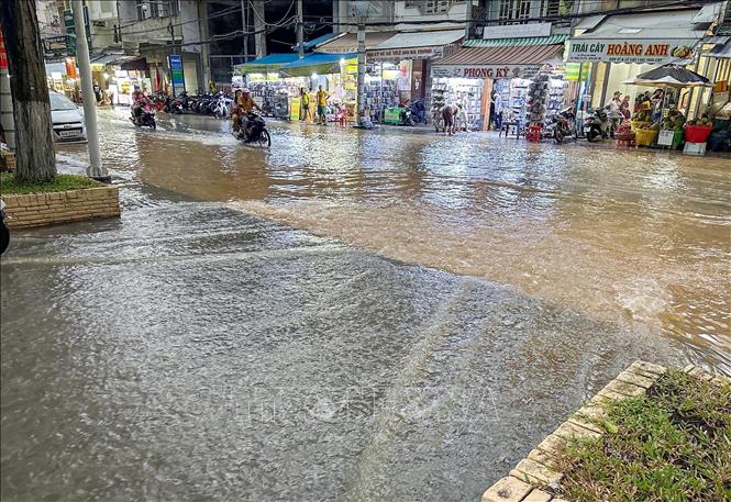
In the central area, on Tran Dai Nghia Street (Cai Khe commercial center), water has overflowed onto the sidewalk. Meanwhile, on Bui Huu Nghia Street and Binh Thuy market area, the flood level is recorded at about 0.4m from the road surface, according to the water level gauge of the authorities. According to the camera images of the people, the flood peak occurred around 1-2am on October 16 and gradually receded around 5am.
According to the Can Tho City Hydrometeorological Station, the water level measured at the Can Tho station on the Hau River at that time was 1.87m, 7cm higher than alarm level I.
Explaining the sudden flooding phenomenon, Mr. Pham Duc Doan, Director of the Hydrometeorological Station of Can Tho City, said that the rising water level was due to the impact of the Northeast monsoon. The strong monsoon pushed water from the sea up, causing the coastal water level to rise, which in turn pushed it back into the main river mouths, causing the water level in Can Tho to rise suddenly.
Mr. Doan affirmed that this is not a high tide and predicted that the water level will only rise a few centimeters today and tomorrow (October 17), then it will slowly decrease following the tide trend and will have to wait until the 28th-29th lunar day (around October 28-29, 2025) to rise again.
According to the leader of the Can Tho City Hydrometeorological Station, the flood in the upper Mekong River is still high and is on a downward trend with the tide, but when the Northeast monsoon pushes the tide up, the Can Tho area, a low-lying area, will be very sensitive to the tide, leading to the normal peak tide being pushed up suddenly.
Sharing the same opinion about the impact of floods from upstream, Master Nguyen Huu Thien, an independent research expert on the ecology of the Mekong Delta, said that although today may be low water according to the tidal schedule, the high water level is still maintained by the water of the Mekong River pouring in. "If today is low water, not low water, then this flooding is definitely due to the flood of the Mekong River," Mr. Thien said. This shows that the flooding is due to the high water level maintained by the Mekong River and only during high water hours of the day.
Commenting on the upcoming flood trend, the report of the Southern Institute of Water Resources Research ( Ministry of Agriculture and Environment ) in weekly newsletter No. 12 (from October 1, 2025 to October 15, 2025) forecasts that the peak of the main flood season in 2025 in the upper Mekong Delta will peak between October 8 and October 12.
Specifically, the water level at the headwaters of the Mekong River at Tan Chau Station on the Tien River is forecast to reach 3.5 - 3.7m, 0.1-0.3m higher than Alarm Level I, and 0.3-0.5m higher than the average of many years. At Chau Doc Station on the Hau River, the water level is forecast to reach 3.3 - 3.5m, 0.3-0.5m higher than Alarm Level I, and 0.6-0.8m higher than the average of many years.
According to experts, the flood water on the Mekong River flowing into the Mekong Delta is affected by the water at Kratie station and Tonle Sap Lake (Cambodia). Data on October 16 from the Mekong River Commission showed that the water level measured at Kratie station was 18.35m, 3.16m higher than the average year and 0.09m higher than 2000 (the year of the major flood in the Mekong Delta). At Tonle Sap Lake, it was 8.58m, 0.41m higher than the average year and 1.36m lower than 2000. However, the water level at Tonle Sap Lake was still 3.37m higher than 2019, the year of the historic drought and salinity in the Mekong Delta.
Source: https://baotintuc.vn/kinh-te/can-tho-ngap-bat-thuong-du-khong-phai-ky-trieu-cuong-20251016135202848.htm


![[Photo] Closing ceremony of the 18th Congress of Hanoi Party Committee](https://vphoto.vietnam.vn/thumb/1200x675/vietnam/resource/IMAGE/2025/10/17/1760704850107_ndo_br_1-jpg.webp)


![[Photo] Nhan Dan Newspaper launches “Fatherland in the Heart: The Concert Film”](https://vphoto.vietnam.vn/thumb/1200x675/vietnam/resource/IMAGE/2025/10/16/1760622132545_thiet-ke-chua-co-ten-36-png.webp)


Comment (0)