
The National Center for Hydro-Meteorological Forecasting said that as of 1 p.m. on July 19, the center of the storm was at about 20.1 degrees North latitude; 119.0 degrees East longitude, in the northeastern sea area of the North East Sea. The strongest wind near the center of the storm is level 10, gusting to level 12; moving in the West Northwest direction at a speed of about 20 - 25 km/h, entering the East Sea and strengthening.
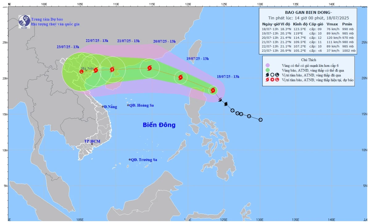
Forecast map of storm Wipha's trajectory and intensity at 2:00 p.m. on July 18, 2025.
Forecast at around 1pm on July 20, the eye of the storm is at around 21.4 degrees North latitude; 114.7 degrees East longitude, about 490 km east of Leizhou Peninsula (China). The strongest wind near the eye of the storm is level 11 - 12, gusting to level 14; moving in the West Northwest direction at a speed of around 20 km/h, and is likely to strengthen further.
The meteorological agency forecasts that around July 22, the storm will move westward, into our mainland, traveling 10-15km per hour and gradually weakening. On land, from July 21-23, the northern provinces and Thanh Hoa will have heavy to very heavy rain.
Ms. Le Thi Loan, Deputy Head of the Weather Forecast Department, National Center for Hydro-Meteorological Forecasting, said that due to the impact of storm No. 3, the sea area east of the North East Sea will gradually increase to level 6 - 7, the area near the storm's center will increase to level 8 - 10, gusting to level 12; waves will be 3 - 5m high. The sea will be very rough. Ships operating in the above-mentioned dangerous areas are likely to be affected by storms, whirlwinds, strong winds, and large waves.
Regarding hot weather, the National Center for Hydro-Meteorological Forecasting said that on July 19, the Northeast region will continue to have hot weather with the highest temperature commonly ranging from 35 - 36 degrees Celsius, some places over 36 degrees Celsius. The area from Thanh Hoa to Da Nang , the eastern provinces from Quang Ngai to Dak Lak and Khanh Hoa will have hot weather, some places will have severe hot weather with the highest temperature commonly ranging from 35 - 37 degrees Celsius, some places over 37 degrees Celsius.
On July 20, the western mountainous areas from Nghe An to Hue, Da Nang, the eastern areas of the provinces from Quang Ngai to Dak Lak and Khanh Hoa will have hot weather with the highest temperature commonly ranging from 35 - 37 degrees Celsius, some places above 37 degrees Celsius. From July 21, the heat in the Central region will gradually ease.
According to VNA/Tin Tuc and Dan Toc Newspaper
Source: https://baoquangtri.vn/cap-nhat-duong-di-cua-bao-so-3-wipha-canh-bao-gay-mua-lon-o-bac-bo-195964.htm


![[Infographic] In 2025, 47 products will achieve national OCOP](https://vphoto.vietnam.vn/thumb/402x226/vietnam/resource/IMAGE/2025/7/16/5d672398b0744db3ab920e05db8e5b7d)


Comment (0)