
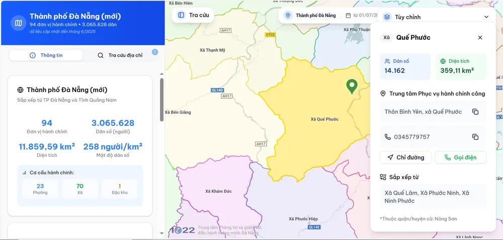
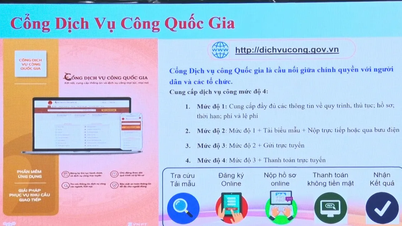
Accordingly, this tool aims to help people easily look up and search for addresses and information related to the Public Administration Service Centers in 94 wards, communes, and special zones of the newly arranged Da Nang City.
People can access the map through two official addresses: https://bando.danang.gov.vn or https://danangmoi.1022.vn.
The digital map not only clearly shows the administrative boundaries of each locality but also integrates the addresses and specific locations of 93 Public Administration Service Centers (which are also the locations of the People's Committees of wards and communes), along with hotline numbers. Seven units have different headquarters locations, including: Hoi An, Hoi An Tay, Tam Ky, Ban Thach, Que Son, Thang Binh and Dai Loc.
In addition, people can look up detailed information about the area and population of each new administrative unit, as well as use navigation and location utilities similar to Google Maps.
The Department of Science and Technology of Da Nang is also coordinating with map service providers such as Google Maps to update the new locations of commune, ward and special zone headquarters on this popular platform. The integration will help people easily search and access new addresses on mobile devices, ride-hailing apps and popular digital maps.
In addition, the Department recommends that agencies and localities widely inform people about this digital map, actively use it in meetings, operations and encourage officials and people to access it to serve their work, especially in administrative procedures.
Source: https://www.sggp.org.vn/da-nang-ra-mat-ban-do-so-hanh-chinh-phuong-xa-dac-khu-post802059.html
![[Photo] Discover unique experiences at the first World Cultural Festival](https://vphoto.vietnam.vn/thumb/1200x675/vietnam/resource/IMAGE/2025/10/11/1760198064937_le-hoi-van-hoa-4199-3623-jpg.webp)

![[Photo] General Secretary attends the parade to celebrate the 80th anniversary of the founding of the Korean Workers' Party](https://vphoto.vietnam.vn/thumb/1200x675/vietnam/resource/IMAGE/2025/10/11/1760150039564_vna-potal-tong-bi-thu-du-le-duyet-binh-ky-niem-80-nam-thanh-lap-dang-lao-dong-trieu-tien-8331994-jpg.webp)
![[Photo] Opening of the World Cultural Festival in Hanoi](https://vphoto.vietnam.vn/thumb/1200x675/vietnam/resource/IMAGE/2025/10/10/1760113426728_ndo_br_lehoi-khaimac-jpg.webp)


![[Photo] Ho Chi Minh City is brilliant with flags and flowers on the eve of the 1st Party Congress, term 2025-2030](https://vphoto.vietnam.vn/thumb/1200x675/vietnam/resource/IMAGE/2025/10/10/1760102923219_ndo_br_thiet-ke-chua-co-ten-43-png.webp)


Comment (0)