
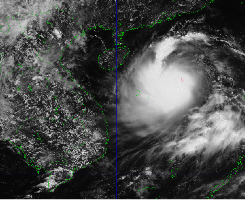
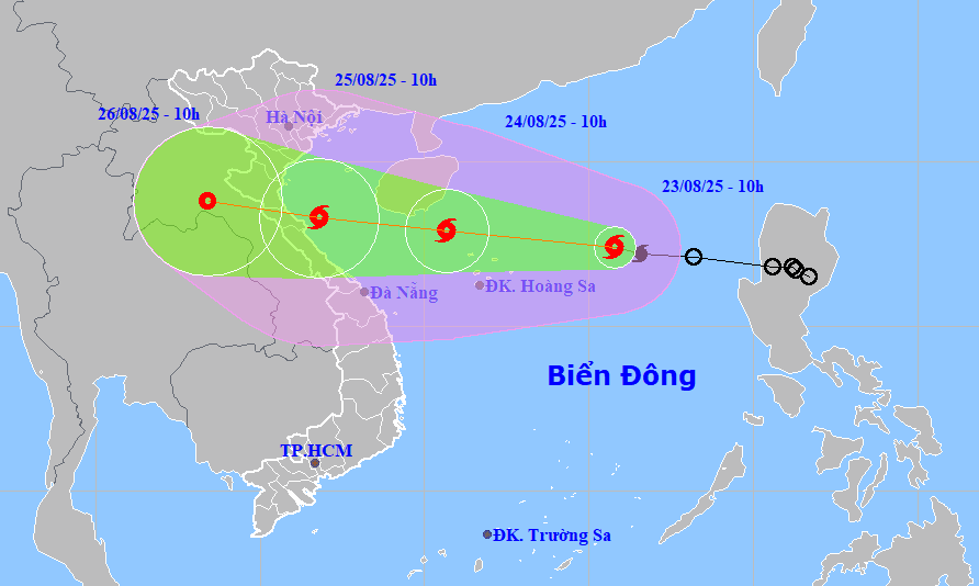
By noon on August 24, the center of storm No. 5 was at about 17.9 degrees north latitude, 110.7 degrees east longitude in the sea northwest of Hoang Sa special zone with the strongest wind at level 10-11, gusting to level 14. The storm continued to move west-northwest at a speed of about 20-25km/hour and continued to strengthen.
By noon on August 25, the center of storm No. 5 was at about 18.3 degrees north latitude, 106.8 degrees east longitude on the sea from Thanh Hoa to Hue with the strongest wind at level 11-12, gusting to level 15. The storm continued to move west-northwest at a speed of about 20km/hour.
Due to the influence of storm No. 5, the North East Sea area (including Hoang Sa special zone) has strong winds of level 8-9, near the storm center of level 10-11, gusting to level 14; waves 4-6m high, rough seas.
From noon and afternoon of August 24, the sea area from Thanh Hoa to Hue (including Con Co, Hon Ngu) has winds gradually increasing to level 6-8, then increasing to level 9-10, the area near the storm center has level 11-12, gusting to level 15. Waves are 4-6m high, the area near the storm center has waves 6-8m high, the sea is very rough.
The northern area of Bac Bo Gulf (including Bach Long Vi) has winds gradually increasing to level 6-7, gusting to level 9, waves 2-4m high, rough seas.
Coastal areas from Thanh Hoa to Quang Tri have storm surges of 0.5-1.0m high.
From the night of August 24, the mainland area from Thanh Hoa to Quang Tri will have winds gradually increasing to level 7-9, near the storm center level 10-12, gusting to level 13-15.
From the night of August 24 to the end of August 26, the Northern Delta region, southern Phu Tho and provinces and cities from Thanh Hoa to Hue will have widespread heavy rain with common rainfall from 100-150mm, locally over 250mm.
Particularly, provinces and cities from Thanh Hoa to Quang Tri will have heavy to very heavy rain with common rainfall of 150-300mm, some places over 600mm. Risk of rain intensity greater than 200mm in 3 hours.
From August 25 to 26, Da Nang will have moderate to heavy rain and thunderstorms. During thunderstorms, be on guard against tornadoes and strong gusts of wind.
On August 23, the People's Committee of Da Nang City issued Official Dispatch No. 03/CD-UBND on implementing measures to respond to storm No. 5 (Kajiki).
Accordingly, the Chairman of the City People's Committee requested departments, branches, localities, agencies, units, organizations, associations and unions to proactively monitor forecast information and developments of tropical depressions; promptly direct and deploy response work to natural disasters; review and complete scenarios and plans to respond to tropical depressions, storms, floods, inundation, landslides, flash floods according to the "4 on-site" motto suitable for each locality, especially in mountainous areas where isolation is likely to occur.
At the same time, proactively evacuate people from dangerous areas, ensure safety of lives, limit damage to people's property when natural disasters occur; deploy work to ensure safety of people, vehicles, property, especially for tourist spots, aquaculture, fishing, and constructions on seas, islands, coastal areas, rivers, streams, mountains, mineral exploitation, etc.
Along with that, focus on directing and immediately implementing measures to ensure safety for ships, vehicles and activities at sea and along the coast, especially to prevent storms and lightning that can cause damage before the storm hits.
The City Military Command, the City Border Guard Command, the Department of Agriculture and Environment, and the People's Committees of coastal communes and wards promptly notify owners of vehicles and vessels operating at sea of the location, direction of movement and developments of the storm so that they can proactively avoid it; escape from or not enter dangerous areas (pay special attention to vehicles operating in the waters of Hoang Sa and Bac Bo Gulf).
Call on ships to urgently come ashore or find safe shelter; proactively develop plans to ensure the safety of ships and have appropriate production plans, ensure the safety of people and property, maintain communication to promptly handle situations that may arise; continue to organize the counting of ships...
The City Border Guard Command will proactively decide on sea bans for fishing boats, transport ships, and tourist boats based on storm developments.
The City Police coordinated with the City Border Guard Command, the Department of Agriculture and Environment and coastal localities to guide fishermen to implement solutions and measures, and arrange permanent forces for fire prevention and fighting when anchoring boats to avoid storms at planned harbors and anchoring points, to prevent fires and explosions; to ensure security, order and safety of State and people's property.
The City Military Command and the City Police coordinated with relevant agencies and units to review response plans, proactively organize and deploy forces and vehicles to be ready to support localities in responding to storms and floods.
The Department of Industry and Trade and the Department of Construction, according to their functions and tasks, direct the work of ensuring safety for industrial production and safety of hydroelectric dams, especially for small hydroelectric dams; guide traffic and ensure traffic safety in flood-affected areas, promptly handle incidents, and ensure smooth traffic.
The Department of Agriculture and Environment directs the work of ensuring safety in agricultural production, aquaculture, dikes, and irrigation dams.
Da Nang Maritime Port Authority inspects and reviews anchoring to ensure safety for cargo ships and transport ships when anchoring in Da Nang Bay.
The Department of Culture, Sports and Tourism, Da Nang Newspaper, Radio and Television, People's Committees of communes, wards, special zones, the city's electronic information portal and the Vietnam Television Center in the Central Highlands region are requested to regularly update the situation and information on natural disasters so that authorities at all levels and people know and proactively respond.
Irrigation and hydropower reservoir management units are on duty 24/7; inspect and monitor dams, promptly detect and handle incidents; closely monitor rainfall and water level developments of reservoirs, regularly report to superior management agencies; effectively notify and inform downstream areas, and operate and regulate reservoirs to ensure proper operating procedures...
Source: https://baodanang.vn/da-nang-yeu-cau-trien-khai-cac-bien-phap-ung-pho-voi-bao-so-5-3300129.html

![[Photo] President Luong Cuong attends the 80th Anniversary of the Traditional Day of Vietnamese Lawyers](https://vphoto.vietnam.vn/thumb/1200x675/vietnam/resource/IMAGE/2025/10/09/1760026998213_ndo_br_1-jpg.webp)

![[Photo] Prime Minister Pham Minh Chinh chairs a meeting of the Government Standing Committee on overcoming the consequences of natural disasters after storm No. 11](https://vphoto.vietnam.vn/thumb/1200x675/vietnam/resource/IMAGE/2025/10/09/1759997894015_dsc-0591-jpg.webp)

![[Photo] General Secretary To Lam visits Kieng Sang Kindergarten and the classroom named after Uncle Ho](https://vphoto.vietnam.vn/thumb/1200x675/vietnam/resource/IMAGE/2025/10/09/1760023999336_vna-potal-tong-bi-thu-to-lam-tham-truong-mau-giao-kieng-sang-va-lop-hoc-mang-ten-bac-ho-8328675-277-jpg.webp)


Comment (0)