
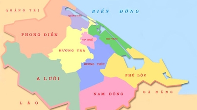
In the territory of Thua Thien Hue , following the coastal plain, one encounters lagoons, then a range of sand dunes acting as a barrier to the shore, and finally the coastal sea. The outer boundary of the coastal sea is conventionally defined as 12 nautical miles (equivalent to 22.224 km). Although lagoons, sand dunes acting as barrier to the shore, and the coastal sea differ in morphology and distribution, they are interrelated and mutually influential throughout the formation of this entire territorial system. Therefore, the territory encompassing lagoons, sand dunes acting as barrier to the shore, and the coastal sea can be considered to belong to the same geological system and is called the coastal zone.
The topography of the Tam Giang - Cau Hai - An Cu lagoon and coastal area, including lagoons , sand dune ranges acting as coastal barriers , and the coastal sea, has created the attractive landscape it is today. The area of sand dunes and lagoons accounts for nearly 9% of the province's total area.
The system of lagoons, estuaries, bays, and beaches in Thua Thien Hue contributes significantly to the socio -economic development of the locality, including scientific tourism, ecotourism, resort tourism, and the protection of the regional ecological environment.
* Tam Giang - Cau Hai Lagoon and An Cu Lagoon : This is a nearly enclosed lagoon system, the largest compared to other lagoons in Vietnam and among the largest in the world . This lagoon system includes the Tam Giang - Cau Hai lagoon system and the isolated An Cu (Lap An) lagoon.
Tam Giang - Cau Hai Lagoon System It is 68km long, has a total water surface area of 216km² and is formed by three lagoons: Tam Giang Lagoon, Thuy Tu Lagoon and Cau Hai Lagoon.
Tam Giang Lagoon: Extending from the mouth of the O Lau River (Lai Ha village) to the Thuan An estuary (Thuan An bridge), with a length of 25 km and an area of 52 km² . The banks and bottom of the lagoon are mainly composed of Holocene sediments. Modern sediments, consisting of silty - clay mud, occupy up to 3/4 of the central lagoon area, followed by silty-clay mud at the mouth of the O Lau River, and to a lesser extent, coarse, medium, and fine sand distributed near the Thuan An estuary. A significant amount of modern bottom sediment contributes to the formation of alluvial plains along the lagoon, island-shaped alluvial plains, and delta-shaped alluvial plains at the mouths of the O Lau and Huong rivers. The lagoon is separated from the East Sea by a series of sand dunes 10-30m high and 0.3 to 5km wide. In the southeast, Tam Giang Lagoon connects to the East Sea through an estuary formed during the historic flood of 1404 near Hoa Duan village. The second estuary, Hoa Duan (also known as Yeu Hai Mon, Noan Hai Mon, Nhuyen Hai Mon, Thuan An, Hai Khau, and Cua Lap), existed for 500 years before being naturally filled in 1904 (Cua Lap). Although still operational, its opening gradually narrowed, reducing its flood drainage capacity. Therefore, from the late 17th to early 18th centuries onwards, during major floods, in addition to Hoa Duan estuary, floodwaters also flowed into the sea through an increasingly deeper and wider channel cutting through a narrow, low sand dune range between Thai Duong Ha village. During the tsunami of October 15, 1897, the channel was deepened and widened into a new estuary called Cua Sut. Cua Sut was later filled in again, and only reopened and widened into the large estuary named Thuan An during the storm of September 19, 1904, which it remains to this day. Conversely, the Hoa Duan estuary was completely filled in during the same storm. The Hoa Duan sluice gate was reopened during the historic flood of November 2, 1999, but it was sealed off again the following year by the Hoa Duan dam.
Thuy Tu Lagoon: This area includes An Truyen, Thanh Lam, Ha Trung, and Thuy Tu lagoons, stretching from Thuan An Bridge to Con Trai over a length of 33km and covering an area of up to 60km² . Here, Quaternary sedimentary formations with similar shore and bottom structures to Tam Giang Lagoon are also found. Regarding modern bottom sediments, the majority are gray, organic-rich silty - clay mud distributed in the center of the lagoon (occupying 4/5 of the area), followed by medium and fine sand. Coarse, medium, and fine sand are commonly found in the alluvial plains along the lagoon, delta-shaped alluvial plains in the Huong River estuary and Thuy Tu lagoon estuary. A series of sand dunes separates the lagoon from the East Sea, ranging in height from 2-2.5m (Thuan An - Hoa Duan) to 10-12m (Vinh Thanh, Vinh My), and width from 0.2-0.3km (near Hoa Duan) to 3.5-5km. (Vinh Thanh, Vinh My).
Cau Hai Lagoon: It has a semicircular basin shape, relatively symmetrical in size, and covers an area of 104 km² . Unlike Tam Giang Lagoon and Thuy Tu Lagoon, the banks and bottom of Cau Hai Lagoon are composed of both loose Quaternary soft sediments and Hai Van complex granite. The uppermost part of the most prevalent modern bottom sediments (occupying 2/3 of the area) consists of dark gray to bluish-gray clayey silt distributed in the center, followed by fine, medium, and coarse sand forming alluvial plains along the southwestern shore, delta alluvial plains at the mouths of Dai Giang, Truoi, and Cau Hai rivers, and tidal delta alluvial plains near Vinh Hien estuary. Cau Hai Lagoon connects to the East Sea via Tu Hien estuary, sometimes Vinh Hien estuary. The sand dune range along the Vinh Hien - Tu Hien coast is approximately 100-300m wide and 1-1.5m high, and is constantly changing like a flat beach. According to historical records, the Tu Hien estuary predates the Hoa Duan and Thuan An estuaries by a long time (possibly around 3,500-3,000 years ago) and has also been known by many names such as O Long, Tu Dung, Tu Khach, and Tu Hien. Although the Tu Hien estuary has not been observed to be completely closed since the opening of the second Hoa Duan estuary in 1404, from the beginning of the 18th century onwards, due to the increasing volume of water passing through the Hoa Duan estuary and the channel between Thai Duong Ha, the volume of water exchange at the Tu Hien estuary decreased, resulting in the estuary narrowing and gradually silting up. It wasn't until 1811, when a severe flood occurred, that the floodwaters breached the sandbar blocking the Phu An shore, creating a new Tu Hien estuary (Vinh Hien) 3km north of the old Tu Hien estuary. From this time onwards, the old and new Tu Hien gates opened and closed with shorter cycles, sometimes alternating (one gate closed, the other open), with the new Tu Hien gate (Vinh Hien) usually not lasting long and being sealed off when the dry season arrived.
Thanks to its enormous water storage capacity (from 300-350 million m³ to 400-500 million m³ in the dry season, and even up to 600 million m³ in the flood season), the Tam Giang - Cau Hai lagoon system also plays a decisive role in delaying floods in the delta region, as well as stabilizing the estuary (opening and closing) and the sand dunes that protect the shore during historical floods (the floods of 1409 and 1999).
An Cư Lagoon (also known as Lập An, Lăng Cô): Compared to the Tam Giang - Cầu Hai lagoon system, An Cư Lagoon is a separate body of water, extending almost in a North-South direction and located north of the Bạch Mã - Hải Vân mountain range. It is also a nearly enclosed lagoon, relatively isometric, and covers an area of 15 km². Similar to Cầu Hai Lagoon, besides Quaternary marine sediments in the high sand dune barrier (3-10m high, 0.3-1.5km wide), the banks of An Cư Lagoon are also composed of granite. At the lagoon bottom, above the rough granite surface, sand and gravel containing shells are commonly found, with less frequently gray ash powder distributed in the center. An Cư Lagoon connects to the sea through a estuary 6-10m deep south of Lộc Hải (Lăng Cô estuary).
* The coastal dune barrier: Located between the coastal plain or lagoon on the inside and the East Sea on the outside is a series of coastal dunes extending in a general northwest - southeast direction from Dien Huong to the foot of Hai Van Pass. Since ancient times, the coastal dune barrier stretching from Cua Viet to Vinh Phong Mountain has been known as Dai Truong Sa. The formation of this coastal dune barrier includes yellow-brown sea sand of the Phu Xuan Formation, gray-white sea sand of the Nam O Formation, and yellow-gray, ilmenite-rich sea-wind sand of the Phu Vang Formation. The presence of these marine sedimentary formations indicates that the coastal dune barrier was formed in the late Pleistocene and completed in the late Holocene. The total area of the coastal dune barrier is approximately 4% of the province's natural area.
Excluding sections of coastline composed of granite, the chain of sand dunes acting as a barrier along the shore has a total length of approximately 100km. From Dien Huong to Vinh Hien estuary, although there is the Linh Thai granite promontory, the coastline remains almost straight. Starting from South Vinh Hien to the An Cu lagoon estuary (at the foot of Hai Van Pass), the coastline is no longer straight but winding and uneven due to the Chan May Tay and Chan May Dong granite promontory jutting out into the sea. From Chan May Dong promontory to the An Cu lagoon estuary, the coastline becomes straight again, restoring its original Northwest-Southeast orientation.
Traveling from Northwest to Southeast, it's easy to see that the width of the sand dune range decreases from 4,000-5,000m in Dien Huong to about 200-300m in Thuan An and Hoa Duan, then widens again to 3,500-4,000m in Vinh Giang and Vinh Ha. Unlike the northern section of the sand dunes, the sand dunes from Vinh Hien estuary to An Cu lagoon estuary are discontinuous, have negligible width, and exhibit complex variations. The width of the sand dunes in the Vinh Hien and Tu Hien sections is only about 100-300m. From Chan May Tay to An Cu lagoon estuary, the width of the sand dunes widens, but still does not exceed 300-1,000m.
Similar to width, the height of the sand dunes also varies continuously and complexly across space. In Dien Mon and Dien Loc, the height reaches 20-25m, decreasing to 10-15m from Dien Hoa to Quang Ngan, and rising again to 32-35m from Quang Cong to Hai Duong. The coastal section from the south of Thuan An to Phu Dien is the lowest area, with a height ranging from 2-2.5m (Hoa Duan) to 5-8m (Phu Dien). From Phu Dien to Vinh Hien estuary, the height of the sand dunes fluctuates less significantly, ranging from 5-12m. In the Vinh Hien and Tu Hien sections, not only the width but also the height of the sand dunes blocking the shore only reaches 1-1.5m and is constantly changing. From Chan May Tay cape to An Cu lagoon estuary, the height of the sand dunes increases but does not exceed 3-10m. Furthermore, the surface of sand dunes is generally uneven and has complex undulations. Where the sand dunes are highest, the ground is least flat and also where sand movement due to wind towards the plains or lagoons is strongest. Here, the sand dunes have an asymmetrical structure (Thai Duong): the southwest slope (25-30 ° ) is steeper than the northeast slope (5-15 ° ).
Continuing from the stretch of coastline with sand dunes and sand dunes interspersed with granite promontory in the North (extending over 110km) is the Hai Van granite erosion coastline (Bai Chuoi). Along this stretch, not only are the sand accumulation areas and eroded sea terraces very narrow and discontinuously distributed, but in many places, boulders are piled up haphazardly from the foot to the middle of the mountain slopes, sloping towards the sea (Bai Chuoi).
* Coastal waters : For Thua Thien Hue, the coastal waters are also characterized by two parts: sand-accumulating coastal waters (Dien Huong - Loc Hai) and granite-eroding coastal waters of Hai Van.
For the sandy coastal section, within 12 nautical miles, the nearshore seabed is relatively flat and slopes gently towards the center of the South China Sea. On this relatively gentle and flat seabed surface, almost exclusively Quaternary sedimentary cover is found, in which modern coastal marine sediments comprise four main facies: beach sediments, deltaic estuary sediments, bay sediments, and nearshore marine sediments.
The most common beach sediments, distributed almost along the entire length of the 100km coastline, are pale yellow to grayish-white medium-grained quartz sand (0.25-0.5mm), with less common coarse-grained sand (0.5-1mm) and fine-grained sand (0.1-0.25mm). The sand contains many shells, and in some places, ilmenite...
The coastal waters near the Thuận An and Tư Hiền estuaries contain silty sand deposits (0.05-0.1 mm). Delta river mouths are formed by submerged sand dikes and islands. These dikes and islands frequently change shape , especially during heavy rains, floods, or storms and strong northeast monsoon winds. The main source of material for these dikes and islands is carried out by the river. In Chân Mây Bay, from the shore out about 300-500m, fine sand is found, followed by silty sand. Coarse and medium-grained sand, light yellow in color, is only found in limited quantities at the Bù Lu estuary. Both bay and beach sediments are brought in from offshore by waves and coastal currents.
Following the beach sediments, delta estuary sediments, and nearshore bay sediments, we immediately encounter nearshore seabed sediments. These nearshore seabed sediments mainly consist of fine sand, silt, and silt, with less clay. Fine sand is distributed up to an isobath of 15m, while from depths of 15-20m onwards, silt (0.05-0.1mm), silt (0.002-0.05mm), and in some places clay (<0.002mm) are found. However, pebbles and gravel are also present at a depth of about 10m in the southeast.
From a geomorphological perspective, the coastal area of sand accumulation belongs to the continental shelf of the Gulf of Tonkin. From the shore to a depth of 90m (coastal area), the average seabed slope is approximately 0.0025. It is noteworthy that the closer to the shore, the steeper the seabed slope becomes. The nearshore zone of the northern part of Thuan An has a common seabed slope of 0.052, with a depth contour of 10m. Located 100-2,000m offshore, the seabed slopes gently at depths of 90-150m with an average gradient of 0.00075. Above 150m, the seabed slope increases again. The overall surface of the seabed is relatively flat but slopes gently towards the center of the East Sea. Recently, several micro-landmarks have been discovered. Firstly, outside the Thuan An estuary, there are two rows of ancient sand dunes located at depths of 16-20m and 25-30m. Inside the dunes are depressions running nearly parallel to the shoreline. Furthermore, an ancient riverbed, 300-500m wide and 12km long, begins at the 34m isobath and flows along the continental shelf. Within the 90-100m depth range, numerous ancient erosional depressions with depths ranging from 2-3m to 9-10m still exist.
Unlike the open coastal areas where sand accumulates, the surface of the Hai Van coastal erosional and rugged granite shoals is primarily composed of sand, with some areas containing gravel, pebbles, and even boulders. Beach sand sediments are also found on Son Cha Island. In addition to sand, gravel, pebbles, and boulders, biological sediments in the form of coral reefs, ranging in width from 10-20m to 100-200m, are also present. The Hai Van coastal slopes in the rugged section are generally not flat and are very steep. The general slope of the seabed varies within the range of 0.035 - 0.176, and even up to 0.287.
According to the Thua Thien Hue Gazetteer - Natural Section
(Social Sciences Publishing House - 2005)
![[Photo] Delegates attending the opening session of the 14th National Congress of the Party](/_next/image?url=https%3A%2F%2Fvphoto.vietnam.vn%2Fthumb%2F1200x675%2Fvietnam%2Fresource%2FIMAGE%2F2026%2F01%2F20%2F1768881998853_ndo_br_1-jpg.webp&w=3840&q=75)


![[Image] Ho Chi Minh City simultaneously commences construction and breaks ground on 4 key projects.](https://vphoto.vietnam.vn/thumb/1200x675/vietnam/resource/IMAGE/2026/01/15/1768472922847_image.jpeg)


Comment (0)