
With the view of developing Xuan Truong district in the direction of stability - sustainability - fairness, ensuring 4 socio-economic goals, sustainable environment and stable political security, social order and safety and justice, adapting to climate change; having open space connecting with the marine economic zones of the two provinces of Nam Dinh and Thai Binh , trade and service development planning, on August 30, 2024, the Provincial People's Committee issued Decision No. 1872/QD-UBND approving the adjustment of the construction planning of Xuan Truong district to 2030, with a vision to 2050.
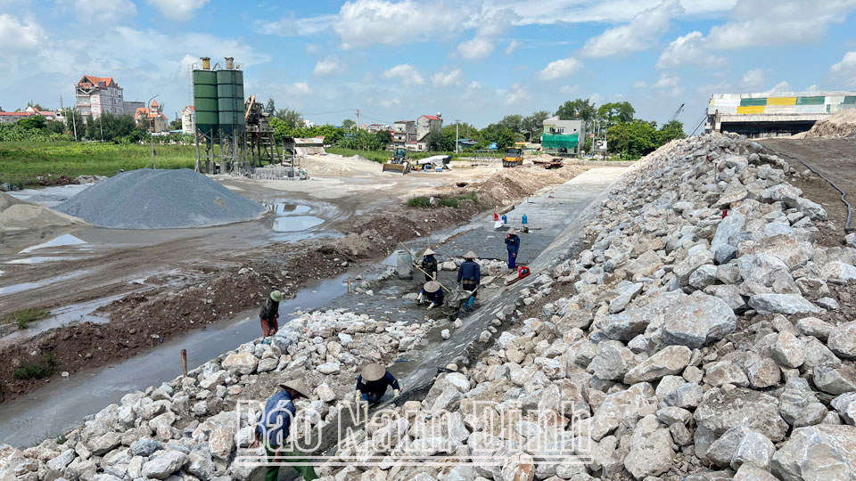 |
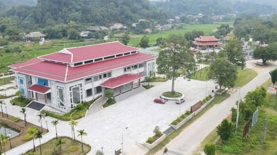
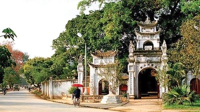
| Construction of new road Nam Dinh - Lac Quan - Coastal road section through Xuan Truong district. |
Xuan Truong district is located in the province's marine economic zone with socio-economic infrastructure being focused on upgrading, especially the road traffic system, electricity, telecommunications, education, etc., which have been invested and upgraded to be modern, creating a solid foundation for socio-economic development; the majority of the workforce is skilled and trained, contributing significantly to promoting the development of key industries such as textiles, mechanics, shipbuilding, construction materials production, etc. According to Decision No. 1872/QD-UBND of the Provincial People's Committee, the planning scope includes the entire administrative boundary of Xuan Truong district with an area of over 116km2 with the following objectives: developing Xuan Truong district in association with national and provincial infrastructure, located on new economic corridors (the North-South development axis of Nam Dinh province) connecting the district, inter-district and the Northern coastal plain, especially the development corridor along the Quang Ninh - Hai Phong - Ninh Binh expressway; exploiting the advantage of being adjacent to the coastal economic zone of Nam Dinh province (Giao Thuy and Hai Hau districts) and being the center of the southern urban area of the province, with advantages in industrial, urban and service development; promoting existing advantages with a large proportion of service industry, being one of the key rice growing areas of the province, with favorable natural conditions for agricultural development, especially specialty rice and short-term industrial crops...
Accordingly, based on natural conditions, current status, the overall organization of the district space by 2030, with a vision to 2050, is organized according to the structure of "1 corridor; 2 development zones; 4 economic axes; 4 urban areas; 6 dynamic development areas". In which, the riverside ecological corridor (Ninh Co River - Red River with a total length of over 30km) is the main waterway traffic axis, connecting ecological urban areas to create a driving force for riverside economic development. 2 development zones include: the Southern development zone - the central zone with a natural area of about 4,928 hectares (the zone concentrates on administrative, political, urban development, trade and services, industry, agriculture with the center being Xuan Truong urban area (expanding Xuan Ninh commune), and Xuan Phuc, Xuan Vinh, Tra Lu communes; the Northern development zone has a natural area of about 6,681 hectares (developing industry, tourism, services, logistics, river ports with the center being Hong Ngoc urban area, Thuong Thanh industrial park). 4 economic axes include: North - South economic axis (developing a comprehensive, multi-sector, multi-field economy in industry, urban areas, trade and services and is an important economic development axis of the district along provincial roads 489C, 484); Northern urban-industrial axis (development axis connecting Xuan Hong, Thuong Thanh industrial parks with Hong Ngoc urban area and is the development driving force The northern economic region of the district is linked to provincial road 488); the central urban axis (administrative, service and commercial axis linked to provincial road 489, connecting the district urban area - Xuan Truong town with the North-South economic axis and industrial clusters (CCN) Nam Dien, Xuan Vinh, the eastern agricultural region); the southern industrial - service - commercial axis (connecting Xuan Kien Industrial Park, Xuan Tien Industrial Park, production and business areas and regional trade and service centers at the intersection of provincial road 489C and provincial road 484, is a trade hub connecting with Nam Dinh city, Quat Lam town and coastal areas of Hai Hau and Giao Thuy districts linked to National Highway 21, provincial road 484, Lac Quan - Ngo Dong route). By 2030, the district will develop 2 urban areas including: Xuan Truong (expanded) as a type IV urban area and Hong Ngoc as a type V urban area; the vision to 2050 is to form more urban areas Tra Lu and Xuan Phuc towns are both type V urban areas. The six dynamic development areas of the district are identified as follows: Xuan Truong district urban area (Xuan Truong - Xuan Ninh); Thuong Thanh Industrial Park; Xuan Hong Industrial Park; Xuan Kien and Xuan Tien industrial parks and clusters; Hong Ngoc urban and tourism services; Xuan Phuc urban and commercial services.
To meet the development requirements of Xuan Truong district by 2030, with a vision to 2050 according to the above goals, Decision No. 1872/QD-UBND of the Provincial People's Committee clearly states the orientation for synchronous development of technical infrastructure systems; in which the highlight is traffic infrastructure. Accordingly, the district's traffic infrastructure is oriented to develop both roads and waterways. Regarding roads, the district has the Ninh Binh - Hai Phong expressway (CT.08) with a scale of 4 lanes passing through the area, the intersection with provincial road (DT) 489C is arranged at the locations of Xuan Phong and Xuan Thuy communes, proposing to build a service road on both sides of the expressway through the district according to the approved Provincial Planning for the period 2021-2030. National Highway 21 running along the South towards Hai Hau district will be upgraded and expanded to at least a level III plain road or higher; by 2050 it will reach a level II plain road; The location of the connection points complies with Decision No. 2420/QD-UBND dated December 23, 2022 of the People's Committee of Nam Dinh province. In addition, in the district, there are also the following routes: DT484 (new road route Nam Dinh - Lac Quan - Coastal Road) planned to meet the standards of a grade I plain road; Upgrading DT488 to meet the scale of a grade III plain road, the section through the town is planned as an urban road; DT489 The section from Sa Cao ferry to Trung Linh culvert is planned to expand to meet the standards of a grade III plain road, the section from Trung Linh culvert to Xuan Bang slope is an urban road with a cross-section of 19m, the section from Xuan Bang slope to Dam Sen culvert is an urban road with a cross-section of 32m, the section from Dam Sen culvert to Nam Dien B bridge is planned to expand to meet the standards of a grade III plain road; The entire DT489C route from the foot of Lac Quan bridge to Sa Cao bridge (new) is planned to become National Highway 39B, upgraded to the scale of a level II plain road, the section through Xuan Truong town is an urban road with a cross-section of 22.5m; the Truc Tuan - Yen Dinh branch route, the section passing through Xuan Truong district in the South (Xuan Ninh commune area), is about 1km long, planned to meet the standards of a level I plain road; the Lac Quan - Ngo Dong branch route, the section passing through Xuan Truong district, is about 3.3km long, planned to meet the standards of a level II plain road with a minimum scale of 4 lanes. The 2031-2050 period is oriented to build green belt roads surrounding urban areas with the aim of zoning development areas and nature conservation areas, protecting urban areas from climate change, and minimizing encroachment pollution. The minimum scale is completed at level IV-III. Upgrading, renovating and combining with new planning of district roads to meet the standards of level III, IV, V in the plains (sections through towns are planned as urban roads). Upgrading inter-commune roads and commune axes to at least level VI in the plains, investing in solid construction of village roads to reach 100% compared to new rural standards...
Regarding waterway traffic, Sa Cao general cargo port will be built on the Red River, Xuan Chau commune with a capacity of 300 thousand tons/year, an expected area of 46 hectares; Tho Nghiep port, Tho Nghiep commune is expected to be at the confluence of So and Ma rivers with a capacity of 300 thousand tons/year; Lac Quan wharf (Ninh Co river) will be renovated and upgraded by 2030 to reach a capacity of 100-200 thousand tons/year.
To manage and implement the planning, the Provincial People's Committee prioritizes projects in the Nam Dinh Provincial Planning for the period 2021-2030, with a vision to 2050, approved by the Prime Minister in Decision No. 1729/QD-TTg dated December 29, 2023. Prioritizing the implementation of framework infrastructure projects, key works to ensure connectivity between industrial - service areas, tourism, urban and rural development; investment projects for urban areas (Xuan Truong, Hong Ngoc, Tra Lu, Xuan Phuc), areas with industrial parks, industrial clusters, nature reserves, national historical sites; projects serving the urban upgrading project, projects to renovate and upgrade social infrastructure works; Construction investment projects using advanced, modern, environmentally friendly technology, effectively exploiting natural resources, renewable energy projects and natural environment regeneration.
Article and photos: Thanh Trung
Source: https://baonamdinh.vn/kinh-te/202410/dieu-chinh-quy-hoach-xay-dung-vung-huyen-xuan-truong-phat-trien-xung-dang-la-trung-tam-vung-do-thi-phia-nam-cua-tinh-40a70f0/


Comment (0)