
Latest cold air news: According to the forecast of the National Center for Hydro-Meteorological Forecasting, early this morning (February 7), cold air has affected some places in the northern mountainous region. Hanoi area: very cold, some places are very cold. The lowest temperature in this cold air mass is commonly 10-12 degrees Celsius.
Update the latest cold air news
According to the National Center for Hydro-Meteorological Forecasting, on February 7, this cold air mass will affect other places in the North, North Central and some places in the Central Central, then affect other places in the Central Central and some places in the South Central. Northeast winds inland will strengthen to level 3, coastal areas to level 3-4, with gusts of level 6 in some places.
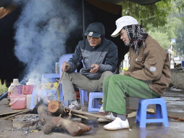
Latest cold air news: Hanoi area: very cold, some places are very cold. The lowest temperature in this cold air wave is commonly 10-12 degrees. Photo: VNA
In the North, the weather is very cold; from the night of February 7, the North Central region will turn very cold, the area from Quang Binh to Hue will turn very cold, some places will be very cold. The lowest temperature during this cold air mass in the North is generally 9-12 degrees, in mountainous areas 5-8 degrees, in high mountainous areas below 3 degrees in some places; in the North Central region, it is generally 11-14 degrees, in the area from Quang Binh to Hue, it is generally 14-16 degrees.
Hanoi area: very cold, some places very cold. The lowest temperature in this cold air mass is commonly 10-12 degrees.
Meanwhile, from the morning of February 7, in the Gulf of Tonkin, the Northeast wind is strong at level 6, sometimes at level 7, gusting to level 8-9, rough seas, waves 2.0-4.0m high; in the North East Sea (including the waters of Hoang Sa archipelago), the Northeast wind is strong at level 6, then increasing to level 7, especially in the East, sometimes at level 8, gusting to level 9-10, rough seas, waves 5.0-7.0m high.
From the afternoon of February 7, the sea area from Quang Tri to Ca Mau , the area between the East Sea and the western sea area of the South East Sea (including the sea area west of Truong Sa archipelago) will have northeast winds gradually increasing to level 6, sometimes level 7, gusting to level 8-9, rough seas, waves 4.0-6.0m high. From the night of February 7, the sea area east of the South East Sea (including the sea area east of Truong Sa archipelago) will have northeast winds gradually increasing to level 6, gusting to level 7-8, rough seas, waves 4.0-6.0m high.
Forecast time | Area of influence | Lowest temperature ( o C) | Average temperature ( o C) |
Day and night 07/02 | North | 9-12, mountainous areas 5-8, high mountainous areas in some places below 3 | 13-15; mountainous areas 11-13; Lai Chau, Dien Bien: 16-18 |
North Central Coast | 12-15 | 15-17 | |
Day and night 08/02 | North | 9-12, mountainous areas 5-8, high mountainous areas in some places below 3 | 12-14; mountainous areas 10-12; Lai Chau, Dien Bien: 14-16 |
North Central Coast | 12-14 | 14-16 | |
Quang Binh to Hue | 14-16 | 16-19 |
The widespread cold spell in the North and North Central provinces is likely to last until around February 10. Due to the influence of the strengthening cold air combined with the strong current in the upper westerly wind zone, from February 7 to the morning of February 8, the North and Thanh Hoa regions will have rain; from February 7-9, the area from Nghe An to Khanh Hoa will have rain, showers, locally heavy rain and thunderstorms.
The mountainous areas of the North are likely to experience snow and ice. Thunderstorms are likely to produce tornadoes, lightning and strong gusts of wind.
Strong winds and large waves at sea can affect the operation of ships and other activities. Severe cold, frost, snow and ice can affect livestock and poultry; greatly affect the growth and development of crops.
Thunderstorms accompanied by tornadoes, lightning and strong gusts of wind can affect agricultural production, cause trees to fall, damage houses, traffic works and infrastructure.
Localized heavy rains can cause flooding in low-lying areas; flash floods in small rivers and streams, and landslides on steep slopes.
Weather forecast for regions across the country on February 7:
Hanoi capital is cloudy, rainy. Northeast wind gradually increases to level 3. The weather turns cold, some places are very cold. Lowest temperature 10-12 degrees Celsius. Highest temperature 13-16 degrees Celsius.
The Northwest is cloudy with rain. Light wind. The weather turns cold and very cold. There is a possibility of snow and frost in the highlands. The lowest temperature is 9-12 degrees Celsius, some places below 7 degrees Celsius; in Lai Chau-Dien Bien it is 13-16 degrees Celsius. The highest temperature is 15-18 degrees Celsius, some places in the Northwest are above 19 degrees Celsius.
The Northeast region is cloudy and rainy. The Northeast wind gradually increases to level 3, coastal areas level 3-4, with gusts of level 6 in some places. The weather turns cold and very cold. There is a possibility of snow and frost in mountainous areas. The lowest temperature is 9-12 degrees Celsius, in mountainous areas 5-8 degrees Celsius, in high mountainous areas below 2 degrees Celsius in some places. The highest temperature is 13-16 degrees Celsius; in mountainous areas 11-13 degrees Celsius.
The area from Thanh Hoa to Hue is cloudy, with rain, showers, locally heavy rain and thunderstorms. The North to Northwest wind gradually strengthens to level 3, coastal areas level 3-4, some places have gusts of level 5. From tonight, the North will turn cold, the South will turn cold. The lowest temperature in the North is 12-15 degrees Celsius, in the South is 15-18 degrees Celsius. The highest temperature in the North is 18-21 degrees Celsius, in the South is 21-24 degrees Celsius, some places are over 24 degrees Celsius.
Provinces and cities from Da Nang to Binh Thuan are cloudy, with rain in some places, especially in the North in the afternoon and at night there will be rain, showers, locally heavy rain and thunderstorms. During the day, the northeast wind is level 2-3, at night the wind gradually increases to level 3-4. The lowest temperature is 19-22 degrees Celsius. The highest temperature in the North is 25-28 degrees Celsius, in the South is 28-31 degrees Celsius.
The Central Highlands region is cloudy, sunny during the day, with some rain at night. Northeast wind level 2-3. Cold in the early morning and at night. Lowest temperature 15-18 degrees Celsius, some places below 14 degrees Celsius. Highest temperature 26-29 degrees Celsius.
The South is cloudy, sunny during the day, no rain at night, sunny during the day. Northeast wind level 2-3. Lowest temperature 21-24 degrees Celsius, in the East some places below 21 degrees Celsius. Highest temperature 30-33 degrees Celsius, in some places above 33 degrees Celsius.
Source: https://danviet.vn/cuc-hot-don-dinh-diem-khong-khi-lanh-cuc-manh-ha-noi-mua-phun-gia-bac-thoi-diem-nao-lanh-nhat-20250207073012245.htm


![[Infographic] In 2025, 47 products will achieve national OCOP](https://vphoto.vietnam.vn/thumb/402x226/vietnam/resource/IMAGE/2025/7/16/5d672398b0744db3ab920e05db8e5b7d)


Comment (0)