
Attending the Conference were Deputy Prime Minister Tran Hong Ha; Ministers of Labor, Invalids and Social Affairs, Agriculture and Rural Development, Transport, Health, Culture, Sports and Tourism, Natural Resources and Environment; Minister, Head of the Government Office, Ethnic Minorities Committee; Governor of the State Bank; General Director of Vietnam Television, Voice of Vietnam , VNA; Leaders of the Ministries of Finance, National Defense, Public Security, Planning and Investment, Foreign Affairs, Industry and Trade, Construction... and secretaries of provincial and municipal Party Committees of 26 provinces and cities.

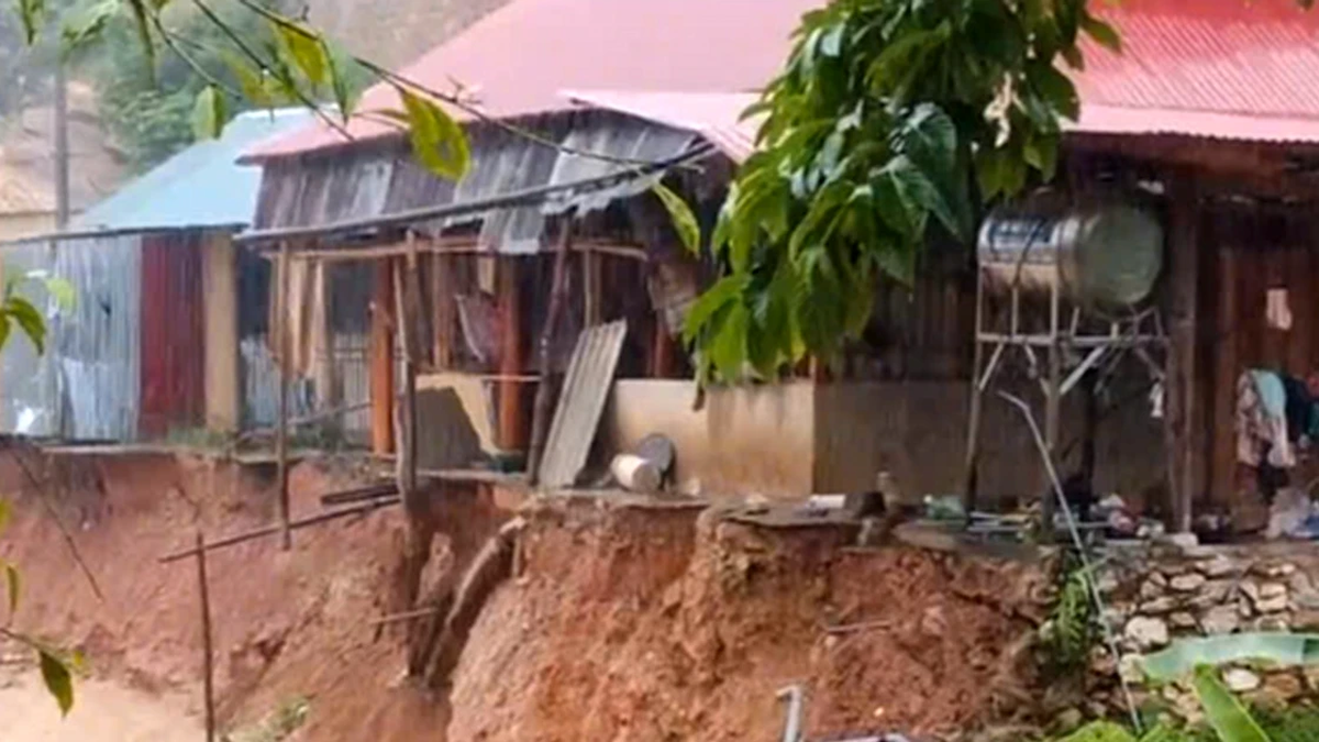
Storm No. 3 ( Yagi ) is a historic storm with very strong intensity and great destruction, causing heavy rain in 26 provinces and cities in the northern region, causing very serious consequences for people and property, negatively affecting production, business and people's livelihoods.
The conference aims to review, evaluate and draw lessons from the work of preventing, combating and overcoming the consequences of storm No. 3, and at the same time propose solutions to restore production and business, stabilize people's lives and promote economic development.

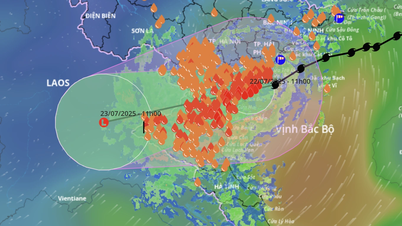
Speaking at the conference, Minister of Natural Resources and Environment Do Duc Duy emphasized that storm No. 3 has unusual characteristics. This is the strongest storm in the past 30 years in the East Sea, making landfall in the North at the end of the rainy season in the North, the reservoirs have entered the water storage phase to serve the dry season.
It is a storm that increases in intensity very quickly (from storm to super typhoon (increased 8 levels in 48 hours) and maintains super typhoon level for a long time. When it makes landfall in the East of Hainan Island (China), it still maintains super typhoon intensity.
The level of degradation along the way does not follow the usual rule: normally when passing Hainan Island (China) into the Gulf of Tonkin, storms often weaken quickly, but with storm number 3, the intensity did not decrease quickly, when approaching the coast of Quang Ninh - Hai Phong, it still maintained the intensity of level 12-13.
Wide area of influence, long stay on land (12 hours), usually only about 6-8 hours or quickly dissipates. The reason is because the area affected by strong winds is wide, weakening slowly on land.
About the forecasting results:
Basic, accurate, timely and similar to warnings from regional and world meteorological and hydrological agencies. Vietnam participates in the regional and world network of agencies including the United States, Japan, Korea, Hong Kong (China)... The Center shares and exchanges with international experts and the results are similar.
About difficulties and limitations:
Not calculated, forecasted strong wind gusts of level 17 on land (never happened in history) and storm duration longer than normal.
With current technology, it is not possible to forecast heavy rain intensity over 200mm/6h. Current calculation information cannot determine the intensity of heavy rain in a short period of time and localize the concentrated rainfall in the Thao and Lo river basins.
Without calculation or early forecast, historical floods rose rapidly with great intensity at some locations on the Thao River.
No detailed warnings have been given to villages, hamlets, flash flood and landslide points.
About the cause:
The geological terrain characteristics of the Northern mountainous midland region are strongly divided and have complex spatial variations.
There are many unusual factors in the development of storm number 3 and the nature of rain and floods.
Technology for monitoring and forecasting natural disasters (storms, rain, floods, flash floods, landslides) has reached the level of countries in the region, but is still limited in assessing and forecasting extreme and unusual indicators as desired.
The technology to forecast and warn of flash floods and landslides in detail down to each village and hamlet is currently very difficult and scientifically limited, even in developed countries (even when there is a sufficiently dense rain and ground movement monitoring system).
Overall assessment of the work of warning, forecasting, and disseminating information on floods and landslides by the Hydrometeorological Agency, Ministry of Natural Resources and Environment has been carried out seriously, promptly, and in accordance with regulations. The forecasting and warning information is basically consistent with the actual developments of floods and landslides, although in reality there are many abnormalities, and is also consistent with the forecasts of international forecasting agencies that are updated hourly. However, the forecast of extreme and abnormal indexes and detailed forecasts of flash floods and landslides in each village have not been as expected.
About suggestions and recommendations:
Regularly monitor information on hydrometeorological forecasts and warnings and combine with local knowledge and experience to have response and prevention plans, especially in vulnerable locations and areas.
Proactively coordinate with the Ministry of Natural Resources and Environment to develop large-scale maps of landslides in accordance with Decision No. 1262/QD-TTg of the Prime Minister dated October 27, 2023 approving the Project on Early Warning of Landslides and Flash Floods in the Northern Midlands and Mountains.
The Ministry of Industry and Trade, the Ministry of Agriculture and Rural Development and localities urge competent agencies and reservoir owners to strictly and fully implement the regulations of the Inter-reservoir Operation Procedures on river basins, and implement the monitoring and information regime for reservoirs in accordance with the provisions of the law on water resources. Review reservoir operation plans with extreme flood scenarios, especially the Central region which is being warned of the possibility of heavy floods and the flood season ending late in October-November 2024 due to the impact of the La Nina phenomenon. At the same time, study and propose a plan to use a part of the flood prevention capacity above the normal water level of large and important reservoirs to improve the ability to reduce floods downstream when emergency and unusual situations occur as prescribed in Clause 8, Article 50 of the Law on Water Resources.
Source: https://baotainguyenmoitruong.vn/bo-truong-do-duc-duy-du-bao-bao-so-3-co-ban-chinh-xac-kip-thoi-tuong-dong-voi-canh-bao-cua-cac-co-quan-khi-tuong-thuy-van-trong-khu-vuc-va-the-gioi-380797.html


Comment (0)