
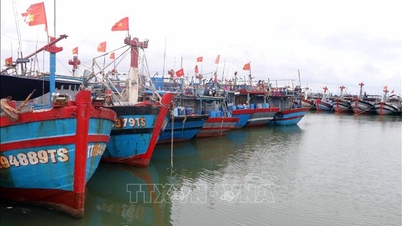
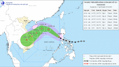
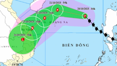
On the morning of October 20, the National Center for Hydro-Meteorological Forecasting said that at 4:00 a.m. the same day, the center of storm No. 12 was located at about 17.5 degrees North latitude and 117.2 degrees East longitude, about 540 km East-Northeast of Hoang Sa archipelago. The strongest wind near the center of the storm reached level 9 (equivalent to 75-88 km/h), gusting to level 11. The storm is forecast to continue moving northwest at a speed of about 25 km/h.

The National Center for Hydro-Meteorological Forecasting believes that in the next 24 to 72 hours, storm No. 12 will move in a complicated manner (it may still strengthen in the near future). From today until tomorrow morning, October 21, the storm will move in the West-Northwest direction, at a speed of about 20km/hour. The wind is strong at level 11, gusting at level 13. However, from the morning of October 21 to October 22, the storm will change direction to the Southwest, at a speed of about 10km/hour. The storm's intensity is currently at level 10-11, gusting at level 13. The dangerous sea area at this time is the sea area west of the North East Sea (including Hoang Sa special zone) and the sea area from Hue to Quang Ngai .
From October 22 to the morning of October 23, the storm continued to move southwest at a speed of about 10km/hour, operating in the sea area from Hue to Quang Ngai but the intensity tended to decrease to level 8, gusting to level 10.
“From the next 72 to 96 hours, the storm will continue to move mainly in the southwest direction, traveling about 10km per hour and gradually weaken into a low pressure area,” the National Center for Hydro-Meteorological Forecasting said.
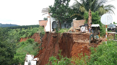
The new and notable point in the update this morning, October 20, from the National Center for Hydro-Meteorological Forecasting is that due to the influence of storm circulation and cold air combined with East wind disturbances and terrain effects, on the mainland of the Central region, from about October 22 to 27, the area from Ha Tinh to Quang Ngai will have widespread heavy rain, lasting for many days, with some areas having very heavy rain, with a high risk of flash floods and landslides in mountainous areas.
The National Center for Hydro-Meteorological Forecasting recommends that these localities prepare response plans for flood scenarios on rivers from Quang Tri to Quang Ngai that may reach alert level 3 and exceed alert level 3 (at the same time, the natural disaster risk level is ranked at level 3).
Source: https://www.sggp.org.vn/hoan-luu-bao-so-12-va-khong-khi-lanh-se-gay-mua-lon-keo-dai-nhieu-ngay-post818934.html
![[Photo] Solemn opening of the 10th Session, 15th National Assembly](https://vphoto.vietnam.vn/thumb/1200x675/vietnam/resource/IMAGE/2025/10/20/1760937111622_ndo_br_1-202-jpg.webp)
![[Photo] The Steering Committee of the 2025 Fall Fair checks the progress of the organization](https://vphoto.vietnam.vn/thumb/1200x675/vietnam/resource/IMAGE/2025/10/20/1760918203241_nam-5371-jpg.webp)


Comment (0)